
International Date Line facts for kids

.jpg)
The International Date Line (IDL) is an imaginary line on Earth's surface. It runs from north to south mostly through the Pacific Ocean. This special line helps us know what day it is around the world.
When you travel across the International Date Line, the date changes. If you go west, the date becomes one day later. If you go east, the date becomes one day earlier. It's like skipping a day or reliving a day!
This happens because of time zones. Countries to the west of the line (like in Asia) are many hours ahead of Greenwich Mean Time (GMT). Countries to the east (like Alaska or Hawaii) are many hours behind GMT. So, when you cross the line, you might need to adjust your watch by almost a whole day!
For example, New Zealand is 12 hours ahead of GMT. But Hawaii is 10 hours behind GMT. If you fly from New Zealand to Hawaii, you would set your clock back 22 hours. This means you arrive almost a full day before you left!
Contents
Where is the International Date Line?

The International Date Line generally follows the meridian of 180° longitude. This line is in the middle of the Pacific Ocean. It's a good spot because there isn't much land there. But the line has to bend to avoid crossing through countries. This keeps all parts of a country on the same date.
In the north, the date line bends around Russia and Alaska. It goes through the Bering Strait. This makes sure Russia and Alaska are on opposite sides of the line. This way, each country has a consistent date. The line passes between two small islands, Little Diomede Island (USA) and Big Diomede Island (Russia). They are only about 1.5 kilometers (1 mile) apart!
The date line also bends far to the east to go around the country of Kiribati. This makes sure all of Kiribati's many islands are on the same date.
In the South Pacific, the line swings east again. This keeps islands like Wallis and Futuna, Fiji, Tonga, and New Zealand on the same date. But Samoa is one day earlier.
Travel and the Date Line
The International Date Line can be confusing for people traveling by plane. Imagine flying from Tonga to Samoa. The flight takes only about two hours. But because you cross the Date Line, you arrive the day before you left! This can make things tricky for hotel bookings or other plans.
Here are some examples of how much time changes on real flights:
- Alaska to Siberia: 21 hours
- New Zealand to Cook Islands: 22 hours
- Samoa to Tonga: 24 hours
If someone travels around the world from east to west, like Ferdinand Magellan, they would normally lose time. They would subtract one hour for every 15 degrees of longitude they cross. This means they would lose 24 hours for a full trip around the globe. But when they cross the International Date Line (from east to west), they add 24 hours. So, the total time adjustment for a trip around the world is zero!
For a short time each day, three different dates can be observed at once. For example, at 10:15 AM UTC (Coordinated Universal Time) on a Thursday, it could be Wednesday 11:15 PM in Samoa. At the same moment, it could be Friday 12:15 AM in Kiritimati. Kiritimati is part of Kiribati and is separated from Samoa by the IDL.
Challenges with the Date Line
The International Date Line was first set along the 180° meridian. This was a good choice because there's not much land there. However, some areas caused problems.
Land Areas and Islands
One problem area is the Chukchi Peninsula in Russia. This land is on the 180° meridian. To keep all of Russia on the same date, the line was moved. Now, all of Russia (and Asia) is on the same side of the date line.
Many groups of islands are in the Pacific Ocean. Countries that own these islands want all their islands to be on the same date. So, the date line has been moved around them. For example, the Aleutian Islands are part of Alaska. Even though some are east of the 180° meridian, they are all on the same date as Alaska. This makes the date line have a "bump" to the west there.
Some islands east of the 180° meridian belong to New Zealand. It was decided they should have the same date as New Zealand. So, the date line runs east of the meridian there.
Kiribati is a country made of many small islands spread across a huge part of the Pacific. The 180° meridian went right through it. In 1995, the date line was shifted far to the east. This was the biggest shift ever. It made sure all of Kiribati had the same date. The easternmost island of Kiribati was even renamed Millennium Island. This is because it was the first place in the world to see the new millennium!
Long ago, the Philippines traded a lot with Mexico. So, they wanted to have the same date. The date line was to the west of the Philippines. But when trade with China grew, this became difficult. So, in 1844, they made a change. After Monday, December 30, 1844, came Wednesday, January 1, 1845. They skipped a day!
Religious Observance
Different religions have special holy days each week. For example, Muslims consider Friday holy. Jews and some Christians observe Saturday as the Sabbath. Most Christians observe Sunday. This works well if you stay in one place. But if you travel across the date line, it can be confusing. For a traveler, it might still be Friday, but the place they arrive might say it's Saturday.
Related pages
Images for kids
-
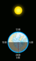
A simple drawing showing how the date line, date, and time of day are connected. Each color shows a different date.
-
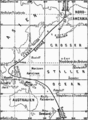
This map from 1888 shows an old, incorrect International Date Line. It ran between the Spanish Philippine Islands and British Hong Kong. The Philippines were shown on the eastern side, even though they moved to the western side in 1845. The Bonin Islands and Fiji were also shown incorrectly.


See also
 In Spanish: Línea internacional de cambio de fecha para niños
