
Millennium Island facts for kids


Caroline Island, also known as Caroline Atoll, is a beautiful group of small islands in the Pacific Ocean. It is part of the country of Kiribati. This atoll is the most eastern part of Kiribati and is one of the Southern Line Islands.
Caroline Atoll is made up of 39 tiny islands, called motus. All these islands together have a land area of about 400 hectares. The entire atoll, including the water inside, covers about 24 square kilometers.
Europeans first saw Caroline Island in 1606. Later, in 1868, the United Kingdom claimed it. Since 1979, when Kiribati became an independent country, Caroline Island has been part of the Republic of Kiribati.
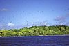
Even though people have lived there and done things like guano mining (collecting bird droppings for fertilizer) and copra harvesting (collecting dried coconut meat) in the past, Caroline Island is still one of the most untouched tropical islands in the world. It is home to many animals, including one of the largest groups of coconut crabs. It's also a very important place for seabirds to lay their eggs, especially the sooty tern.
Today, Caroline Atoll is a special place for wildlife. The government of Kiribati made a rule in 2014 that no one can fish within 12 nautical miles around Caroline Island and other nearby islands like Flint and Vostok. Flint and Vostok islands are about 230 kilometers to the west. The city of Papeete, Tahiti is about 849 kilometers to the south.
Geography of Caroline Island
Caroline Island stretches about 13 kilometers from north to south and about 3 kilometers from east to west. The total land area is quite small, only about 3.76 square kilometers. The coral reef around the atoll extends about 1.5 kilometers out into the ocean.
The water inside the atoll, called the lagoon, is very shallow. This means that regular boats usually cannot enter it. When the tide is high, it's possible to reach a beach by boat. But at low tide, you might need to walk about 400 meters through water that is waist-deep to get to the beach.
There are two larger islands at the north and south ends of the atoll. The one in the north is called Nake Island, and the one in the south is called South Islands. Both of these larger islands have sources of freshwater underground, called aquifers.
In 1994, Kiribati changed the International Date Line. This was done so that all of Kiribati would be on the same date. Because of this change, Caroline Atoll became the first land on Earth to see the new day. For the celebrations of the year 2000, the atoll was even renamed Millennium Island. In the past, it was also known by other names like Hirst Island, Clark Island, and Independence Island.
The island is a very important place for birds to breed. The only known mammal living on the atoll is a type of rat.
Image gallery
-
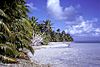
The lagoon side of South Islet on Caroline Atoll.
-
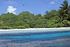
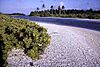
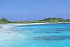
The beautiful lagoon on Caroline Atoll.
-
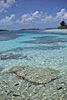
Clear, shallow waters of the lagoon on Caroline Atoll.
-
Brothers Islet, one of the many small islands on Caroline Atoll.
-
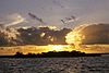
A lovely sunset over Fishball Islet on Caroline Atoll.
-
The channel between Long Islet and Nake Islet on Caroline Atoll.
-
An ancient Polynesian marae (a sacred meeting place) on Caroline Atoll.
-
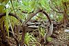
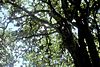
Cordia trees growing on North Arundel Islet on Caroline Atoll.
-
Psionia trees on Caroline Atoll.
-
Shark Islet on Caroline Atoll.
-
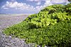
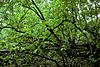
A thicket of Scaevola plants on Windward Islet on Caroline Atoll.


Images for kids
-

Caroline Island, clearly visible in a photograph taken by an astronaut in 2009. The inner lagoon looks lighter blue than the deeper ocean.
-
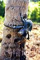
The coconut crab, a species that might be endangered, lives on Caroline Island.


See also
 In Spanish: Isla Caroline para niños
