Little Diomede Island facts for kids
|
Native name:
Iŋaliq (Inupiaq)
|
|
|---|---|

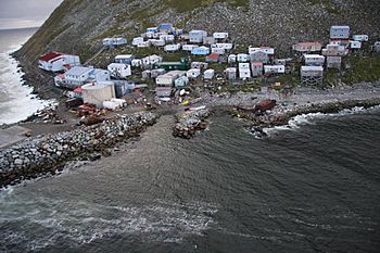
The native Iñupiat village of Diomede/Iŋaliq on Little Diomede Island
|
|
| Geography | |
| Location | Bering Strait |
| Coordinates | 65°45′15″N 168°55′15″W / 65.75417°N 168.92083°W |
| Archipelago | Diomede Islands |
| Area | 2.43 sq mi (6.3 km2) |
| Highest elevation | 1,621 ft (494.1 m) |
| Administration | |
| Demographics | |
| Population | 77 (2023) |
| Pop. density | 33.72 /sq mi (13.019 /km2) |
| Ethnic groups | 96% Iŋaliq Iñupiaq |
| Additional information | |
| Time zone | |
Little Diomede Island is also known as Yesterday Island. Its native name is Inupiaq: Iŋaliq. This island is located off the coast of Alaska and is part of the United States.
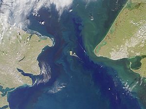
It is the smaller of the two Diomede Islands. These islands sit in the middle of the Bering Strait. This strait is a narrow waterway between Alaska and Siberia, Russia. The only town on Little Diomede Island is called Diomede.
Just 2.33 miles (3.75 kilometers) to the west is Big Diomede Island. This larger island belongs to Russia. An international border separates the two islands. Also, the International Date Line runs between them. This means Big Diomede is always one day ahead of Little Diomede.
In 2021, the town of Diomede had 82 people living there. This number was lower than its highest population of 208 in 1998. All the land on Little Diomede Island is part of the town of Diomede. The island is not part of an organized county or borough. So, the state of Alaska helps provide some services. For counting purposes, it is part of the Nome Census Area.
During the Cold War, the border between the U.S. and the USSR here was called the "Ice Curtain". In 1987, a swimmer named Lynne Cox swam from Little Diomede to Big Diomede. This was about 2.2 miles (3.5 km). Both Mikhail Gorbachev and Ronald Reagan praised her swim.
Contents
Naming the Diomede Islands
The Diomede Islands get their name from Saint Diomedes. A Danish-Russian explorer, Vitus Bering, first saw these islands. He discovered them on August 16, 1728. This was the day the Russian Orthodox Church celebrates Saint Diomedes. The Bering Strait is also named after Vitus Bering.
The local Inupiaq name for Little Diomede is Iŋaliq. This means "the other one" or "the one over there." Little Diomede is often called "Yesterday Island." Big Diomede Island is known as "Tomorrow Island." This is because the International Date Line separates them. It makes the date on Big Diomede always one day ahead.
Island History
To learn more about the history of the island, you can visit the main article: Diomede, Alaska (town).
Island Geography
Little Diomede Island covers about 2.8 square miles (7.3 km2) of land. The village of Diomede, also called Iŋaliq, is on the western shore.
The island is about 25 kilometers (16 mi) west of the Alaskan mainland. It sits right in the middle of the Bering Strait. It is only 0.6 kilometers (0.4 mi) from the International Date Line. It is also about 2.4 miles (3.9 km) from the Russian island of Big Diomede.
The highest point on Little Diomede Island is 494 meters (1,621 feet) tall. This spot is about halfway along the west coast. It faces the southern tip of Big Diomede.
There is a heliport on the island, called the Diomede Heliport. Helicopters fly there regularly. In the past, people carved a runway into the thick ice. This allowed small planes to bring important supplies. These supplies included medicine and groceries. The runway's location changed each year because of ice changes.
However, due to climate change, the sea ice is not thick enough anymore. It is also not stable enough for planes to land safely. The ice needs to be at least 4.5 feet thick. The last flight landed in May 2013. There has not been an ice runway since then.
Island Climate
Summer temperatures on Little Diomede average 40 to 50 °F (4 to 10 °C). Winter temperatures usually range from 6 to 10 °F (−14 to −12 °C). The island gets about 10 inches (250 mm) of rain each year. It also gets about 30 inches (76 cm) of snow annually.
During the summer, the skies are often cloudy and foggy. Winds usually blow from the north. They average 15 knots (17 mph; 28 km/h). Gusts can reach 60 to 80 miles per hour (97–129 km/h). The Bering Strait is typically frozen from mid-December to mid-June.
Island Geology
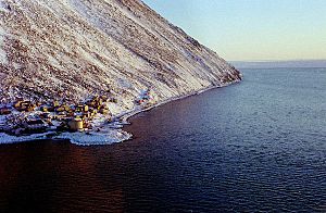
Little Diomede Island is made of rock called granite or quartz monzonite. These rocks formed during the Cretaceous period. The area where the town is located is the only place without steep cliffs. Behind the town and all around the island, rocky slopes rise at about 40 degrees. They reach a flatter top area about 1,148–1,191 feet (350–363 m) high. The island has very little plant life.
Little Diomede in Pop Culture
Little Diomede Island has appeared in several TV shows and books.
- It was shown in the first episode of Full Circle with Michael Palin. This was a 1997 BBC show. In it, Michael Palin traveled around the Pacific Rim.
- The Diomede Islands are also in the novel Further Tales of the City. This book was written by Armistead Maupin. A miniseries was also made based on the book.
- Alexander Armstrong visited the island in his 2015 series Land of the Midnight Sun.
- Little Diomede was also in the 1952 movie Arctic Flight. This film starred Wayne Morris and Lola Albright.
See also
 In Spanish: Diómedes Menor para niños
 | Selma Burke |
 | Pauline Powell Burns |
 | Frederick J. Brown |
 | Robert Blackburn |


