
Pacific Ring of Fire facts for kids


The Pacific Ring of Fire is a huge, horseshoe-shaped area around the Pacific Ocean. It's famous for having lots of volcanoes and earthquakes. About three-quarters of the world's active and sleeping volcanoes are found here. This ring stretches for 40,000 kilometers (about 25,000 miles) and contains 452 volcanoes.
Most of the world's earthquakes happen along the Ring of Fire. About 90% of all earthquakes and 15% of the largest ones occur here. The next most active earthquake zone is the Alpide belt. It goes from Java to Sumatra, through the Himalayas, and across the Mediterranean Sea.
The Ring of Fire exists because of something called plate tectonics. This is the way the Earth's huge outer plates move and crash into each other.
What Causes the Ring of Fire?

The Ring of Fire is a direct result of plate tectonics. This is the scientific idea that Earth's outer shell is made of several large pieces called lithospheric plates. These plates are always moving, even if it's very slowly. When they move, they can crash into each other or slide past each other.
One main reason for the Ring of Fire is called subduction. This happens when one tectonic plate slides underneath another.
- On the eastern side of the Pacific, the Nazca Plate and the Cocos Plate are sliding under the South American Plate.
- The Cocos Plate also slides under the Caribbean Plate in Central America.
- Further north, parts of the Pacific Plate and the small Juan de Fuca Plate are sliding under the North American Plate.
As you move west along the ring:
- The Pacific Plate is sliding under the Aleutian Islands.
- It also slides under the Kamchatka Peninsula and Japan.
The southern part of the Ring of Fire is a bit more complicated. Many smaller plates are colliding with the Pacific Plate. This includes areas like the Mariana Islands, the Philippines, Tonga, and New Zealand. However, Australia is not part of the Ring of Fire because it sits in the middle of its own tectonic plate.
Indonesia is an interesting case. It's located between the Ring of Fire (along its northeastern islands) and the Alpide belt (along its south and west, including islands like Sumatra and Java).
Images for kids
-
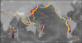
Global map of subduction zones, with subducted slabs contoured by depth
-
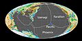
The tectonic plates of the Pacific Ocean in the Early Jurassic (180 Ma)
-
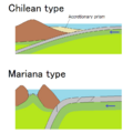
Chilean-type and Mariana-type subduction zones
-
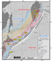
Map of earthquake epicenters at the Kuril–Kamchatka trench and subduction zone
-
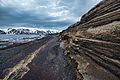
Layers of phreatomagmatic tephra on Deception Island
-
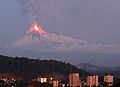
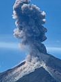
Llaima's 2008 eruption
-
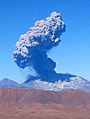
Lascar erupting in 2006
-
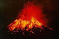
Tungurahua erupting molten lava at night (1999)
-
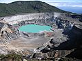
Crater of Poás volcano in Costa Rica, 2004
-
Santiaguito Volcano, 2003 eruption in Guatemala
-
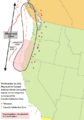
Area of the Cascadia subduction zone, including the Cascade Volcanic Arc (red triangles)
-
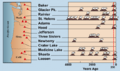
American Cascade Range volcano eruptions in the last 4000 years
-
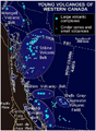
Map of young volcanoes in Western Canada
-
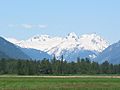
The Mount Meager massif as seen from the east near Pemberton, British Columbia: Summits left to right are Capricorn Mountain, Mount Meager, and Plinth Peak.
-
Kambalny, an active volcano in the Kamchatka Peninsula
-
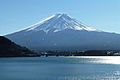
Mount Fuji at sunrise from Lake Kawaguchi
-
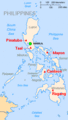
Map showing major volcanoes of the Philippines
-
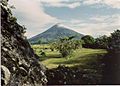
Mayon Volcano overlooks a pastoral scene about five months before the volcano's violent eruption in September 1984.
-
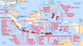
Major volcanoes in Indonesia
-
Papua New Guinea and tectonic plates: Pacific Plate, Australian Plate, Caroline Plate, Banda Sea Plate (as "Mer de Banda"), Woodlark Plate, Bird's Head Plate, Maoke Plate, Solomon Sea Plate, North Bismarck Plate, South Bismarck Plate and Manus Plate (in French)
-
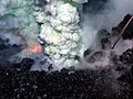
Volcanic eruption at West Mata submarine volcano between Samoa and Tonga, 2010
-
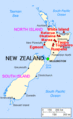
Major volcanoes of New Zealand
-
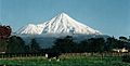
View of Mount Taranaki from Stratford


.jpg)


.jpeg)


See also
 In Spanish: Cinturón de fuego del Pacífico para niños
