Mariana Islands facts for kids
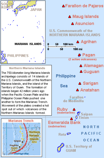
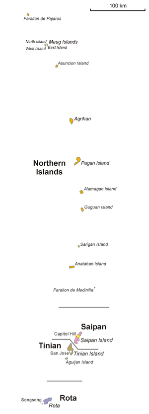
The Mariana Islands are shown, with the territory of Guam to the extreme south, and the Commonwealth of the Northern Mariana Islands (14 islands) to the north. Active volcanoes are shown with triangles.
|
|
| Geography | |
|---|---|
| Location | Pacific Ocean |
| Coordinates | 16°42′N 145°47′E / 16.70°N 145.78°E |
| Administration | |
|
United States
Northern Mariana Islands (U.S.) Guam (U.S.) |
|
The Mariana Islands are a group of fifteen islands shaped like a crescent moon. They are found in the northwestern Pacific Ocean. These islands are actually the tops of mostly sleeping (dormant) volcanoes. They are located south of Japan, west of Hawaii, and east of the Philippines.
The Marianas are part of a larger area called Micronesia. They are split into two parts that belong to the United States. These are the Commonwealth of the Northern Mariana Islands and the territory of Guam. The islands were named after Queen Mariana of Austria from Spain in the 1600s.
The first people to live here were the Chamorro people. Scientists believe they made the longest ocean journey in human history to reach these islands. They also think that Tinian island was the very first island in Oceania to be settled by humans.
European explorers first arrived in the early 1500s. The Portuguese explorer Ferdinand Magellan was one of the first. Spain later took control of the islands. They made Guam, the largest island, their main city. The fresh fruits found here saved Magellan's crew from scurvy, a serious illness.
Contents
Where are the Mariana Islands?
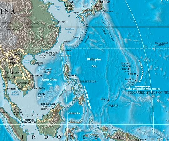
The Mariana Islands are the southern part of a huge underwater mountain range. This range stretches for about 2,500 kilometers (1,565 miles) from Guam all the way to Japan. The islands are located between 13 and 21 degrees north latitude and 144 and 146 degrees east longitude.
The total land area of all the Mariana Islands is about 1,008 square kilometers (389 square miles).
They are divided into two main areas:
- Guam, which is a United States territory.
- The Northern Mariana Islands, which is a Commonwealth of the United States. This includes islands like Saipan, Tinian, and Rota.
The islands are also split into two natural groups. The northern group has ten volcanic islands. Most of these are not lived on today. The southern group has five islands made of coral and limestone. These include Rota, Guam, Aguijan, Tinian, and Saipan. All of these are inhabited except Aguijan. The northern volcanic islands have active craters and sometimes experience earthquakes. The southern islands have coral reefs along their coasts.
The Mariana Trench is the deepest part of Earth's oceans. It is located very close to these islands and is named after them. Many islands in the Marianas still have their original names, like Guahan (Guam), Agrigan, and Saipan.
How the Islands Were Formed
The Mariana Islands are part of a large geologic structure called the Izu–Bonin–Mariana Arc system. The islands in the north are about 5 million years old. The islands in the south, like Guam, are much older, about 30 million years old.
These islands were formed because of how Earth's plates move. The western edge of the Pacific Plate is slowly moving westward. It then dives deep down under another plate called the Mariana plate. This process is called subduction. It is the most volcanically active place on Earth where plates meet.
As the Pacific Plate dives down, water trapped in its rocks gets heated by the Earth's hot interior. This creates a lot of steam and pressure. This pressure causes volcanic activity, which formed the Mariana Islands in an arc shape. The deep Mariana Trench is also formed by this same plate movement.
Plants and Animals
| Marianas tropical dry forests | |
|---|---|
| Ecology | |
| Realm | Oceanian |
| Biome | Tropical and subtropical dry broadleaf forests |
| Bird species | 59 |
| Mammal species | 2 |
| Geography | |
| Area | 1,036 km2 (400 sq mi) |
| Country | United States |
| Territories | Guam and the Northern Mariana Islands |
| Conservation | |
| Conservation status | Critical/Endangered |
| Habitat loss | 76.8% |
| Protected | 1.11% |
Most of the Mariana Islands are covered in thick forests. The plants here are very similar to those found in the Caroline Islands and the Philippines. Many plant species were brought over from the Philippines. The soil is often moist, so there are many types of mosses and grasses. Most islands have a good supply of fresh water.
The animals on the Marianas are similar to those in the Carolines. Some animal species are found only on these island groups. The climate is warm and humid, but the trade winds help keep it from getting too hot. The temperature does not change much throughout the year.
History of the Mariana Islands
Early People and Their Journeys
The Mariana Islands were the first islands in Remote Oceania to be settled by humans. This was a very long ocean journey made by the Austronesian peoples. It was different from the later journeys made by the Polynesian people to other parts of Oceania. The first settlers arrived around 1500 to 1400 BCE. They likely came from the Philippines.
Archaeologists have found ancient pottery on the Mariana Islands. These pots have designs similar to pottery found in the Philippines from the same time. This suggests a connection between the early settlers. Also, the Chamorro language is most like languages from the Philippines.
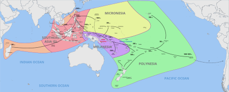
Studies of human DNA also show that the Chamorro people have ancestors from the Philippines. Early skeletons found on Guam do not show ancestry from Australia or Melanesia. This means the first settlers did not come from those areas. The Lapita culture, which led to Polynesian settlements, started later than the first settlements in the Marianas. This suggests they were separate migrations.
However, DNA also shows a close link between early Mariana settlers and early Lapita settlers. This might mean both groups came directly from the Philippines. Or, it could mean early Mariana settlers traveled further south and met the Lapita people.
Around 1000 CE, the Marianas also had contact with people from the Caroline Islands. This brought new pottery styles, languages, and even a new type of breadfruit.
The Latte Period
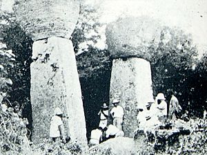
The time from 900 to 1700 CE, just before and during Spanish rule, is called the Latte period. During this time, the culture changed quickly. A key feature was the building of huge stone pillars called latte stones. These stones had a base (haligi) and a capstone (tasa). They were used to support buildings made of wood. The capstones might have also stopped rodents from climbing up.
Graves have been found in front of these latte structures. Another unique thing about the Latte period was the start of rice farming. This was unusual for Pacific Islands before Europeans arrived.
We don't know exactly why these changes happened. But it might have been because of a third group of migrants from Southeast Asia. Similar building styles in the Philippines and eastern Indonesia suggest these new people might have come from there. The Chamorro word haligi (pillar) is used in the Philippines. The Chamorro word guma (house) is similar to a word in Sumba, Indonesia.
Spanish Arrival and Control
The first Europeans to see the Mariana Islands were part of a Spanish expedition led by Ferdinand Magellan. This happened on March 6, 1521. Magellan's ships sailed between two of the islands. The southern village of Umatac, Guam is believed to be where they first landed.
When the Spanish ships arrived in Guam, the local Chamorro people took things from their ships. They even took a small boat. In response, the Spanish attacked the Chamorros. They burned houses and boats and killed seven men. Magellan's crew called the islands Islas de los Ladrones (Islands of the Thieves).
Magellan later claimed the islands for Spain. He named them Islas de las Velas Latinas (Islands of the Lateen Sails) because of the unique sails on the Chamorro boats.
In 1667, Spain officially claimed the islands. In 1668, they named them Las Marianas to honor Queen Mariana of Austria. At that time, over 50,000 Chamorros lived there. When Spanish settlers arrived, they brought new diseases. These diseases caused many deaths among the native Chamorro people. By a century later, only about 1,800 native Chamorros remained. Many people became mixed with Spanish blood.
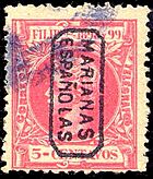
The Mariana Islands were part of the Spanish colony of New Spain (Mexico) until 1817. Then, they became part of the Philippines, which was also a Spanish colony. The islands were an important stop for Spanish ships traveling between Acapulco, Mexico, and Manila, Philippines.
British and American whaling ships also visited the islands often in the 1800s.
Changes in Control
The Marianas stayed a Spanish colony until 1898. After Spain lost the Spanish–American War, they gave Guam to the United States. Since then, Guam has been separate from the Northern Mariana Islands.
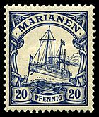
Spain was weakened by the war. They could no longer control all their islands in Micronesia. So, in 1899, Spain sold the Northern Marianas and other islands to Germany. The Northern Marianas became a small part of Germany's colony of New Guinea. At this time, only about 2,646 people lived in the Northern Marianas. The ten northernmost islands were active volcanoes and mostly empty.
During World War I, Japan joined the Allies. They took control of all of Germany's colonies in East Asia and Micronesia, including the Northern Mariana Islands. After the war, the Treaty of Versailles took away all of Germany's colonies. The League of Nations then put these islands, including the Northern Marianas, under Japan's care. Japan used some of the islands to grow sugarcane, which caused a small increase in population.
World War II and After
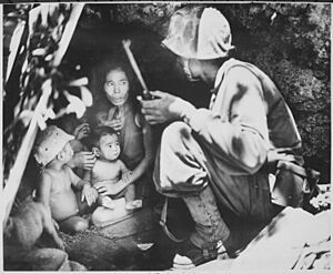
The Mariana Islands saw heavy fighting during World War II. Guam was captured by Japan in December 1941, on the same day as the attack on Pearl Harbor. In 1944, the United States took the Mariana Islands from Japan. The U.S. wanted the Northern Mariana Islands to use as bases for bombing Japan.
The Battle of Saipan began in June 1944. A month later, the U.S. recaptured Guam and captured Tinian. Once these islands were taken, the U.S. military used Saipan and Tinian as bases for their B-29 bombers. These bombers could now reach mainland Japan and return. Japanese forces attacked these bases from November 1944 to February 1945.
From these islands, the United States Army Air Forces launched many bombing raids against Japanese cities. These included Tokyo, Nagoya, Osaka, and Kobe. The famous bombers Enola Gay and Bockscar, which dropped atomic bombs on Hiroshima and Nagasaki, flew their missions from Tinian's North Field.
Historians believe that about 10% of Guam's population (around 20,000 people) were killed during the war. Most were killed by the Japanese Imperial Army and Navy.
After World War II, the Northern Mariana Islands came under the control of the United States. They became part of the U.S.-managed Trust Territory of the Pacific Islands. Later, the Commonwealth of the Northern Mariana Islands became a United States territory. Even though both are now under U.S. control, the Northern Mariana Islands are still separate from Guam. There have been attempts to reunite them, but they have failed. This is partly because Guam was occupied by Japan for only 31 months during the war, while the Northern Mariana Islands were under Japanese control more peacefully for about 30 years.
Islands of the Marianas (North to South)
| Island name | Population (2020 census) | Territory | Administrative divisions |
|---|---|---|---|
| Farallon de Pajaros (Uracus) | 0 | Commonwealth of the Northern Mariana Islands (CNMI)
(unincorporated territory and commonwealth of the USA) Population: 47,329 |
Municipality of Northern Islands
Population: 7 |
| Maug Islands | 0 | ||
| Asuncion | 0 | ||
| Agrihan | 4 | ||
| Pagan | 2 | ||
| Alamagan | 1 | ||
| Guguan | 0 | ||
| Papaungan | |||
| Sarigan | 0 | ||
| Anatahan | 0 | ||
| Farallon de Medinilla | 0 | ||
| Saipan | 43,385 | Municipality of Saipan | |
| Tinian | 2,044 | Municipality of Tinian | |
| Aguijan | 0 | ||
| Rota | 1,893 | Municipality of Rota | |
| Guam | 153,836 | Guam (territory of the USA) | 19 villages of Guam |
There are also underwater landforms in the Marianas, like the Esmeralda Bank, Ruby Seamount, and Supply Reef.
Visiting the Islands
Tourism is a big part of the economy in the Northern Mariana Islands. Many visitors come from the Philippines, Japan, America, South Korea, Taiwan, and China. Most tourism in the Marianas happens in Guam. Many flights arrive in Guam, often in the early morning. Tourism has grown slowly and is now a major part of the economy. Many tourists enjoy visiting the islands and volcanoes.
Food of the Marianas
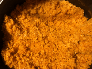
Some popular dishes in the Mariana Islands include red rice. People also enjoy grilled meat or poultry, or meat cooked in coconut milk. Other favorites are chicken kelaguen, which is a dish with lemon juice and coconut. Apigigi is another special food made from young coconut and cassava paste, wrapped in a banana leaf. Tropical fruits are also very common.
See also
 In Spanish: Islas Marianas para niños
- Rail transport on the Mariana Islands
- Apostolic Prefecture of Mariana Islands
- Lists of islands
- Marianas tropical dry forest
- List of endemic plants in the Mariana Islands
- List of birds of the Northern Mariana Islands
- List of mammals of the Northern Mariana Islands
 | Anna J. Cooper |
 | Mary McLeod Bethune |
 | Lillie Mae Bradford |


