Anatahan facts for kids
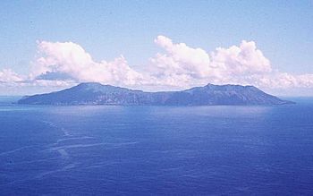
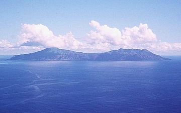
US Geological Survey photo of Anatahan
|
|
 |
|
| Geography | |
|---|---|
| Location | Pacific Ocean |
| Coordinates | 16°21′5″N 145°40′43″E / 16.35139°N 145.67861°E |
| Archipelago | Northern Mariana Islands |
| Area | 33.91 km2 (13.09 sq mi) |
| Length | 9 km (5.6 mi) |
| Width | 4 km (2.5 mi) |
| Highest elevation | 790 m (2,590 ft) |
| Administration | |
|
United States
|
|
| Commonwealth | Northern Mariana Islands |
| Demographics | |
| Population | - uninhabited - (2010) |
| Anatahan | |
|---|---|
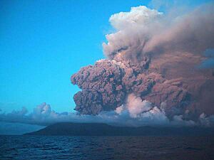
Ash from Anatahan, June 2005
|
|
| Highest point | |
| Elevation | 788 m (2,585 ft) |
| Geography | |
| Location | Northern Mariana Islands, Pacific Ocean |
| Geology | |
| Mountain type | Stratovolcano |
| Last eruption | 2007 – 2008 |
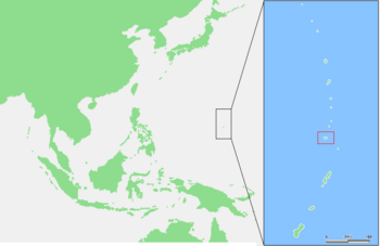
Anatahan is an island in the Northern Mariana Islands in the Pacific Ocean. It is home to one of the most active volcanoes in the area. Because of the danger from volcanic eruptions, no one lives on the island today. Anatahan is about 60 kilometers (37 miles) northwest of Farallon de Medinilla. It is also about 120 kilometers (75 miles) north of Saipan.
Contents
History of Anatahan
Europeans first found Anatahan in October 1543. A Spanish explorer named Bernardo de la Torre charted the island. At that time, the Chamorros lived there.
Spanish Rule
In 1695, the Spanish rulers moved the native people. They were taken to Saipan and later to Guam. Under Spanish control, people started growing coconuts. These coconuts were used to make copra, which is dried coconut meat. In 1884, about 125 tons of copra were sent out from the island.
German and Japanese Control
Spain sold the Northern Marianas to the German Empire in 1899. Anatahan then became part of German New Guinea. By 1901, the island was reported to be empty. In 1902, a company leased the island. They wanted to grow more coconuts. However, strong typhoons in 1905 and 1907 destroyed the farms. This caused the company to go out of business.
During World War II, Japan took control of Anatahan. It was part of the South Seas Mandate.
Japanese Holdouts
In June 1944, about 30 Japanese survivors reached Anatahan. They were from sunken ships. After Japan surrendered in World War II, Americans came to the island. They took two Japanese people and 45 native people away. But some Japanese soldiers refused to believe the war had ended. They hid in the island's forests. These soldiers are known as "Japanese holdouts."
By 1950, a woman named Kazuko Higa led the holdouts. She was the only woman left on the island. There were five men with her. Sadly, some of the men died during their time on the island. The remaining holdouts finally surrendered in June 1951.
Their story became famous. A film called The Saga of Anatahan was made in 1953. A book was also written about their experiences. Later, the story inspired other books and a film.
United States Control
After World War II, the United States took control of Anatahan. It was part of the Trust Territory of the Pacific Islands. Since 1978, the island has been part of the Northern Islands Municipality. This is part of the Commonwealth of the Northern Mariana Islands.
Geography and Volcano
Anatahan is shaped like an oval. It is about 9 kilometers (5.6 miles) long and 4 kilometers (2.5 miles) wide. The island covers an area of about 33.9 square kilometers (13.1 sq mi).
The island is actually the top of a stratovolcano. This type of volcano is cone-shaped and built up by many layers of hardened lava and ash. The highest point of the volcano is about 790 meters (2,592 feet) above sea level.
Volcanic Activity
The volcano has a large bowl-shaped hollow at its top called a caldera. This caldera is about 2.3 kilometers (1.4 miles) wide. It has two parts, an eastern and a western section. The eastern part is lower than the western part.
Some of the lava flows on Anatahan look very new. This means they formed recently in Earth's history. In April 1990, people living on the west coast were moved away. This happened after many small earthquake swarms and active fumaroles (gas vents) showed that an eruption might happen. But no eruption occurred then. More earthquakes happened in May 1992.
The first recorded eruption of Anatahan happened in May 2003. It was a very big explosion. It created a new crater inside the eastern caldera. The eruption sent a huge cloud of ash 12 kilometers (7.5 miles) high. This ash cloud caused problems for airplanes flying to Saipan and Guam. The strength of this eruption was measured as a VEI 4. VEI stands for Volcanic Explosivity Index, which is a way to measure how powerful a volcanic eruption is.
The most recent eruption was in 2007 and lasted until 2008.
See also
 In Spanish: Anatahan para niños
 | John T. Biggers |
 | Thomas Blackshear |
 | Mark Bradford |
 | Beverly Buchanan |


