
Alamagan facts for kids
|
Native name:
Alamagan
|
|
|---|---|

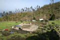
US Geological Survey photo of Alamagan
|
|
 |
|
| Geography | |
| Location | Pacific Ocean |
| Coordinates | 17°36′2″N 145°50′0″E / 17.60056°N 145.83333°E |
| Archipelago | Northern Mariana Islands |
| Area | 12.96 km2 (5.00 sq mi) |
| Length | 4.8 km (2.98 mi) |
| Width | 4 km (2.5 mi) |
| Highest elevation | 744 m (2,441 ft) |
| Highest point | Bandeera Peak |
| Administration | |
|
United States
|
|
| Commonwealth | Northern Mariana Islands |
| Demographics | |
| Population | 0 |
Alamagan is a small island in the Pacific Ocean. It's part of the Northern Mariana Islands. The island is about 48 kilometers (30 miles) north of Guguan. It's also about 400 kilometers (250 miles) north of Saipan. Alamagan is currently empty, with no people living there.
Contents
Island History
Alamagan was once home to the Chamorro people. They left behind old stone columns called latte stones. They also left pieces of pottery. These items show that people lived there a long time ago.
European Discovery and Control
A Spanish missionary named Diego Luis de San Vitores found Alamagan in 1669. He named it Concepción. Before him, a Spanish sailor named Gonzalo de Vigo might have visited in 1522. He was a sailor who left the Magellan trip.
In 1695, the people living on Alamagan were forced to move to Saipan. Three years later, they moved again to Guam.
Changing Hands
Spain sold the Northern Marianas to the German Empire in 1899. Alamagan then became part of German New Guinea. A company started coconut farms there. But big storms in 1905, 1907, and 1913 destroyed the farms. This caused the company to go out of business.
During World War I, Japan took control of Alamagan. It became part of the South Seas Mandate. After World War II, the United States took over. It was part of the Trust Territory of the Pacific Islands. Since 1978, Alamagan has been part of the Commonwealth of the Northern Mariana Islands.
Recent Times
People used to live on Alamagan and grow copra (dried coconut meat). The main villages were Song Song and Patida camp. By 1962, there were so few students that the school closed.
In December 1998, everyone had to leave the island. This was because the volcano was becoming very active. In 2000, only six people lived on Alamagan. In September 2009, Typhoon Choi-wan hit the island hard. It destroyed many trees. The last few people had to move to Saipan. Since 2010, no one has lived on Alamagan.
Island Geography

Alamagan is shaped like an oval. It is about 4.8 kilometers (3 miles) long. It is also about 4 kilometers (2.5 miles) wide. The island covers an area of about 13 square kilometers (5 square miles).
Volcano Features
The whole island is actually the top of a stratovolcano. This volcano rises over 4,000 meters (13,000 feet) from the ocean floor. Its highest point is Bandeera Peak, which is 744 meters (2,441 feet) above sea level.
The volcano has a large bowl-shaped hole at its top. This is called a caldera. It is about 700 to 900 meters wide. It is also about 370 meters (1,214 feet) deep. There are three smaller hills near the main crater.
The volcano has not erupted in modern times. But scientists know it erupted around 540 AD and 870 AD. These eruptions were very powerful. They sent hot ash and gas flowing down the volcano. Hot vents, called fumaroles, are still active inside the main crater. They are also on the western slopes.
Landscape and Plants
The eastern side of the island has very steep slopes. These slopes can have landslides. The western side has deep valleys carved by water. The eastern coast has tall cliffs, up to 100 meters (328 feet) high.
Plants like swordgrass grow on the west side of the island. The southeast side is a bare slope of old lava. Coconut trees grow on the gentler slopes. There are deep valleys with caves. You can also find fresh water springs on the northern part of the west coast.
Important Bird Area
Alamagan is known as an Important Bird Area (IBA). This means it's a special place for birds. It is home to several types of birds. These include Micronesian megapodes and white-throated ground doves. Other birds found here are Micronesian myzomelas, Saipan reed warblers, and Micronesian starlings.
Population Numbers
In 1980, the population of Alamagan was 36 people.
Images for kids
-
Damage on Alamagan after Typhoon Choi-wan

See also
 In Spanish: Alamagan para niños
