
Pagan (island) facts for kids

Mount Pagan, the most active of the two stratovolcanoes on Pagan Island in 1983
|
|
 |
|
| Geography | |
|---|---|
| Location | Pacific Ocean |
| Coordinates | 18°7′N 145°46′E / 18.117°N 145.767°E |
| Archipelago | Northern Mariana Islands |
| Area | 47 km2 (18 sq mi) |
| Length | 16.2 km (10.07 mi) |
| Width | 6.0 km (3.73 mi) |
| Highest elevation | 570 m (1,870 ft) |
| Highest point | Mount Pagan |
| Administration | |
|
United States
|
|
| Commonwealth | Northern Mariana Islands |
| Demographics | |
| Population | 7 (2018) |
Pagan is a volcanic island in the Marianas chain, found in the northwest Pacific Ocean. It is part of the Commonwealth of the Northern Mariana Islands, which is a territory of the United States.
Pagan is located between two other islands: Alamagan to its south and Agrihan to its north. Most people left Pagan Island after a big volcanic eruption in 1981. Since then, only a few people have lived there.
Contents
Island History
Early Settlers and European Discovery
People have lived on Pagan Island for many centuries, even before the time of Christ. The first European to see the island was a Spanish missionary named Diego Luis de San Vitores in 1669. He named it San Ignacio.
Before that, a Spanish sailor named Gonzalo de Vigo might have visited in 1522. He was a castaway from Ferdinand Magellan's trip.
Changes Under Different Countries
In 1695, the native Chamorro were forced to move from Pagan to Saipan. Three years later, they moved again to Guam. In the early 1800s, some Chamorros started to return. They found that people from the Caroline Islands had already settled there.
By the 1870s, the first coconut farms were started on Pagan. In 1899, Spain sold the Northern Mariana Islands to the German Empire. Pagan became part of a German colony called German New Guinea. A company called the Pagan Society used the island to trade copra, which is dried coconut meat.
Typhoons hit the island hard in 1905, 1907, and 1913. These storms destroyed the coconut farms and caused the Pagan Society to go out of business.
World War I and Japanese Control
During World War I in 1914, Japan took control of Pagan. The League of Nations later gave Japan official control as part of the South Seas Mandate. Japanese and Okinawan people moved to the island. They replanted coconuts and grew cotton and sweet potatoes to sell.
The Japanese also started commercial fishing for bonito and tuna. In 1935, an airfield was built. The Imperial Japanese Navy set up a military base in 1937.
By 1942, 413 Japanese people and 229 Chamorro people lived on Pagan. In June 1944, during World War II, 2,150 Japanese soldiers arrived. However, they were cut off from supplies by the Allied forces. Many soldiers died from hunger before Japan surrendered.

After World War II and Recent Events
After World War II, the United States took control of Pagan. It became part of the UN Trust Territory of the Pacific Islands. Later, it became a U.S. Commonwealth.
The U.S. Navy had a small base on Pagan. In the 1950s, they built a church, a warehouse for copra, a small hospital, and a school. By the late 1970s, fewer than 100 people lived on the island. Many of them only stayed there part-time from Saipan.
The 1981 Volcano Eruption
On May 15, 1981, Mount Pagan erupted. Lava flowed over much of the island's farmland and part of the airfield. Everyone living on the island had to move to Saipan. The volcano kept erupting until 1985, with smaller eruptions happening many times after that, even as recently as 2012.
The people who used to live on Pagan have asked to return, but U.S. officials have said no. This is because the volcano is still dangerous. However, there are ongoing efforts to help the about 300 people who want to return to Pagan and other Northern Islands.
In 2006, Pagan Island was part of Operation Christmas Drop. This is an event where the United States Air Force drops supplies to islands. Aircrew saw cattle and some buildings, including a grassy airstrip, on the island.
In 2012, a Japanese group wanted to use Pagan to dump waste from the 2011 Tōhoku earthquake and tsunami. But this plan was stopped after people protested.
Pagan is still part of the Northern Islands Municipality for political reasons.
Island Geography

Pagan is about 320 kilometers (200 mi) north of Saipan, which is the main island of the Northern Mariana Islands. Pagan is the fourth largest island in the Northern Marianas, covering about 47.23 km2 (18.24 sq mi).
The island is actually two stratovolcanoes connected by a narrow strip of land. This strip is only about 600 meters (660 yd) wide.
Southern and Northern Volcanoes
The southern volcano is 548 m (1,798 ft) high. It has a large crater (called a caldera) about 4 km (2.5 mi) wide, made of four smaller craters joined together. This southern volcano last erupted in 1864.
The northern volcano is called Mount Pagan. It is 570 m (1,870 ft) high. It sits in the middle of a caldera that is about 6 km (3.7 mi) wide. Mount Pagan has erupted many times, including in the 1820s, 1872–1873, 1925, and the big eruption from 1981–1985.
Lakes and Islets
Pagan has two large lakes. Laguna Sanhalom (also called Inner Lake) was about 17 hectares (42 acres) in size and 23 m (75 ft) deep in the 1970s. Laguna Sanhiyon (also called Laguna Lake) is on the west coast of the northern part of the island. It was about 16 hectares (40 acres) in size and 20 m (66 ft) deep. Both lakes have brackish water, which means it's a mix of fresh and salt water.
Close to the northern east coast are two very small, steep rock islands. They are called Togari Rock and Hira Rock. These are counted as separate islands in the Northern Islands Municipality.
Population and Education
Island Population Changes
The number of people living on Pagan often changed. For example, students would move between Pagan and Saipan for school. In October 1977, seven families lived on Pagan, with a total of 37 people. By 1980, there were nine families and 85 people, but some of them lived in Saipan.
Schooling on Pagan
Before the 1981 eruptions, the Commonwealth of the Northern Mariana Islands Public School System had an elementary school on Pagan. It taught students up to the 6th grade. In 1977, 13 students attended this school. Older students from Pagan went to secondary school on Saipan.
Military Training Plans
In 2013, the U.S. Naval Command suggested using Pagan Island for new military training. This would include live-fire exercises.
This idea caused many people to protest. Groups like "Our Islands are Sacred" and the Sierra Club spoke out against it.
On April 3, 2015, the Department of Defense (DoD) released a report about the environmental effects. Michael G. Hadfield, a biology professor, said that Pagan is not a "wasteland." He explained that it has unique plants and animals, including endangered bird and snail species.
Jerome Aldan, who was the mayor for the Northern Islands, said that the U.S. military's idea that the island was "uninhabited" was wrong. He said that over 50 families in Saipan still consider Pagan their home. At that time, two people lived on the island in shacks.
On May 15, 2015, a map of the proposed military site was made public online.
Images for kids
-
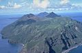
The South Pagan volcano is at the southwest end of Pagan Island. The ridge in the front is part of a 4-kilometer-wide caldera. Inside it, the cone-shaped South Pagan volcano was built. The top of South Pagan has four craters. This volcano erupted in the 1800s but has been less active than the North Pagan volcano, which is the peak in the far center.
-
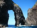
A natural arch on Pagan Island.
-
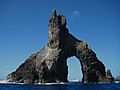
The NOAA Ship HI'IALAKAI seen from Pagan Island through a natural arch.


See also
 In Spanish: Isla de Pagán para niños
