
Caroline Islands facts for kids


The Caroline Islands (also called the Carolines) are a group of many small islands spread out across the western Pacific Ocean. They are located north of New Guinea. Today, these islands are divided into two main political areas: the Federated States of Micronesia in the east and Palau in the far west. Long ago, this area was known as Nuevas Filipinas or New Philippines because it was part of the Spanish East Indies and ruled from Manila in the Philippines.
The Caroline Islands stretch for about 3,540 kilometers (2,200 miles). This distance covers everything from Tobi Island in Palau, which is the westernmost island, all the way to Kosrae in the east.
Contents
What are the Caroline Islands like?
This group includes about 500 small coral islands. They are located east of the Philippines in the Pacific Ocean. For example, the distance from Yap (one of the larger Caroline islands) to Manila is about 1,930 kilometers (1,200 miles).
Most of these islands are low, flat coral atolls. This means they are ring-shaped islands made of coral. However, some islands are much higher and rise above the sea.
People and Culture
.jpg)
The people who originally lived on these islands speak many different languages. These include Micronesian languages like Pohnpeian, Chuukese, Carolinian, and Kosraean. They also speak Western Malayo-Polynesian languages such as Palauan and Chamorro. The unique language Yapese is also spoken. Many people from other places, like the Philippines and Japan, also live here. When islanders from different language groups need to talk for trade, they often use English.
The local people mainly get their food from farming and fishing. They grow many types of bananas and taro, which is a root vegetable. On some islands, homes are still built using local materials like coconut-palm leaves for roofs. Over many years, Christianity became the main religion in this part of Micronesia because of missionaries. However, some local people still believe in traditional spirits, like a good spirit called “Yalafar” and an evil spirit called “Can.” But they usually don't practice old religious ceremonies anymore.
A famous Micronesian navigator named Mau Piailug (1932-2010) was from Satawal island in the Carolines. He learned old navigation skills from the Weriyeng school. These skills were kept alive because the Carolinian Islands were so far away. In the 1970s, Mau shared his knowledge with the Polynesian Voyaging Society. This helped bring back traditional Polynesian navigation methods. It also helped experts understand more about the history of the Polynesian and Micronesian peoples.
History of the Islands
Different islands in the Carolines have their own stories about how they began. For example, on Pohnpei island, people tell stories about three periods before colonial times. These were the Mwehin Kawa (building or peopling era, before 1100), the Mwehin Sau Deleur (era of the Saudeleur rulers, from 1100 to about 1628), and the Mwehin Nahnmwarki (era of tribal chiefs, from about 1628 to 1885).
According to Pohnpeian stories, the Saudeleur rulers came from outside the islands. They were the first to bring a government to Pohnpei. They ruled with strong, central power, which became very strict over time. Their unfair rules and disrespect for Pohnpeian gods made the islanders unhappy. The Saudeleur rule ended when another outsider, Isokelekel, took over. He started a system with more local power, led by nahnmwarki (tribal chiefs). This system continued even when other countries later ruled the islands, and it still exists today.
Spanish Rule

Spanish explorers first came to the Caroline Islands in 1525. A storm blew Portuguese sailors Diogo da Rocha and Gomes de Sequeira to the islands. They stayed for several months. Soon after, in 1526, Spanish explorers Toribio Alonso de Salazar and Diego de Saavedra saw the island of San Bartolomé (Taongui). On January 1, 1528, explorer Álvaro de Saavedra Cerón claimed the Ulithi Islands for the king of Spain. Spanish explorers visited the area again in 1542, 1543, and 1545. In 1565, Miguel López de Legazpi, the first governor of the Philippines, briefly visited.
Europeans did not return until 1686, when Francisco de Lezcano arrived in Yap. He named the islands Las Carolinas to honor Charles II of Spain. This name later included the Palau Islands.
In 1707, Spain allowed missionaries to go to the Caroline Islands. But in 1731, a missionary named Juan Antonio Cantova was killed. Because of this, Spain stopped its connection with the islands. When they returned in 1787, they focused on trade.
In 1885, a Spanish representative signed an agreement with the chiefs of Koror and Artingal. This made the Caroline Islands officially Spanish territory. Spain then tried to charge taxes on trade in the area. However, Germany and the United Kingdom had already set up missions there. They argued against Spain's right to collect taxes. The European countries asked Pope Leo XIII to decide. He ruled that Spain could collect taxes on islands west of the 164th meridian east. Germany would have rights in the Marshall Islands.
After the Spanish–American War in 1898, Spain sold the Carolines and the Northern Mariana Islands to Germany in 1899. Germany paid 25 million pesetas for them. Germany then ruled the islands as Karolinen, connecting them to German New Guinea.
A Stop for Whalers
In the 1800s, the islands were a popular stop for whaling ships. The first known visit was by the London whaler Britannia in 1793. Ships from Britain, the United States, Australia, and other places came for water, wood, and food. Sometimes, they also looked for crew members. These ships brought trade and caused many changes, both good and bad. The most visited islands were Kosrae, Mokil, Ngatik, Pingelap, and Pohnpei.
Japanese Colony
Japan took over the islands in 1914 during World War I. After the war, in 1920, Japan was given permission by the League of Nations to control the Caroline and Marshall Islands. During World War II, Japan had a large military base at Truk Lagoon. They used this base to expand their power in the southeastern Pacific. Later in the war, the Allies attacked Truk in Operation Hailstone, making it unusable for Japan. After the war, the islands became trust territories of the United States. The Federated States of Micronesia became independent in 1986, and Palau followed in 1994.
Religious History
Two Jesuits (Catholic priests), Juan Antonio Cantova and Victor Walter, tried to start missionary work in 1731. Cantova was killed, and Walter had to leave. Two other Jesuits were also killed later. For the next 120 years, there were no missionaries on the islands.
After the Pope decided in 1886 that Spain owned the Carolines, the king of Spain sent Spanish Capuchins (another group of Catholic priests) to the islands. They printed a prayer book in the Ponape language.
In 1899, when Germany bought the islands from Spain, the mission faced problems. Spain had given money to the mission and made local people send their children to school. Germany did not give money and let people choose if they wanted to attend church or school. As a result, many people stopped going. So, in 1904, it was decided that German missionaries would replace the Spanish ones.
By 1906, 24 missionaries were working in thirteen places. Several Sisters of St. Francis came from Luxembourg to run ten primary schools, which had 262 children. That year, the missionaries reported 90 new adult converts. They also said there were 1,900 Catholics, a few Protestants, and 11,600 people who had not become Christian.
In 1905, the United States sent a Jesuit from the Manila Observatory to Yap island. He set up a weather station there. This station helped discover that typhoons (strong storms) in East Asia often started in the Carolines. The station still checks the weather twice a day and warns Manila about severe weather.
Postage Stamps

When Germany controlled the islands, they made special postage stamps for the Carolines.
Getting Around the Islands
People travel within the islands by boat or by air, especially if there is an airfield nearby.
Air travel is mostly for trips between islands, as most airfields are not big enough for large planes. Caroline Islands Air is the only local airline and offers chartered flights.
Images for kids
-
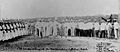
Transfer of power at Yap in the Western Caroline Islands (1899).

See also
 In Spanish: Islas Carolinas para niños
