
Manila facts for kids


Manila is the capital city of the Philippines. It is one of the largest cities in the Philippines. Manila is on Luzon, the biggest island of the Philippines. Manila is located by a bay named Manila Bay. The metropolitan area is much larger. It stretches across a thin strip of land to a lake called "Laguna de Bay".
Contents
What's in a Name?
The Filipino name for the city, Maynilà, comes from the phrase may-nilà. This means "where indigo is found." Nilà comes from an old Indian word, nīla, which refers to indigo dye. This dye comes from several plant species. The city was likely named because these indigo-producing plants grew in the area. It wasn't because the city traded a lot of indigo dye back then. Later, the name Maynilà changed to the Spanish name Manila.
Manila's Story
Ancient Times
The oldest signs of people living in the Manila area are the Angono Petroglyphs. These ancient rock carvings are about 5,000 years old! Early people called Negritos lived in the Philippine islands. Later, Malayo-Polynesian people arrived and mixed with them.
Indian Influence

Manila was first known as Gintô (gold) or Suvarnadvipa by nearby settlements. It was officially called the Kingdom of Maynila. This kingdom grew strong during the later part of the Ming dynasty because it traded directly with China. Ancient Tondo was the main capital, and its rulers were called "lords" or "kings."
Around the 1200s, Manila was a strong settlement and trading area by the Pasig River. Later, the Indianized empire of Majapahit took control of Manila. This is mentioned in an old poem called Nagarakretagama. Manila was known as Selurong back then.
Islamic Kingdom
From 1485 to 1521, Sultan Bolkiah of the Sultanate of Brunei wanted to control the trade with China. He attacked Tondo and set up Kota Saludong (now Manila) as a state connected to Brunei. A new Muslim ruler, Salalila, took charge. Islam became stronger as traders and teachers from Malaysia and Indonesia arrived.
In 1574, a Chinese pirate leader named Limahong attacked Manila for a short time. Later, in 1603, Spanish forces in Manila took action against Chinese residents. The Spanish military believed the Chinese residents might help a possible invasion.
Spanish Rule Begins
On June 24, 1571, Spanish explorer Miguel López de Legazpi arrived from New Spain (which is now Mexico). He took control of Manila for Spain and set up a city council in what is now Intramuros. After a plot called the Conspiracy of the Maharlikas failed, the Spanish took full control.
After this, Manila became the capital of the Spanish East Indies and the Philippine Islands. Spain ruled the Philippines for over 300 years, from 1565 to 1898.
Manila became famous for the Manila galleon trade. For three centuries, ships called galleons carried goods between Manila and Acapulco, Mexico. Goods from Europe, Africa, and Latin America came to Manila. From Manila, goods like Chinese silk, Indian gems, and spices from Southeast Asia were sent to Mexico and then to Europe. Silver from Mexico and Peru was traded for these valuable items.
British Takeover
The city was taken over by Great Britain for two years, from 1762 to 1764. This happened during the Seven Years' War in Europe, where Spain and France fought against Great Britain. Manila remained the capital under British rule, but Spanish leaders continued to resist.
During this time, the Sultan of Sulu, Azim ud-Din I of Sulu, was held by both the British and Spanish. Also, Chinese people in Binondo rebelled against Spain, and Indian soldiers working for the British also rebelled. Eventually, the British left Manila because of agreements made in the Treaty of Paris (1763). Some of the Indian soldiers stayed and settled near Cainta, Rizal. After this, the Spanish fortress city of Intramuros always kept its cannons pointed towards Binondo (the world's oldest Chinatown) to quickly respond to any more Chinese uprisings.
Direct Spanish Rule
After the British left, Spain started to rule Manila directly. This was made easier by the opening of the Suez Canal, which allowed ships to travel faster between Spain and the Philippines. When Mexico became independent, Spain had to rule the Philippines directly. Under this direct rule, banking, industry, and education grew much more than before.
This growth attracted people from India, China, Latin America, Europe, and other parts of the Philippines to Manila. Many of these people started to see themselves as "Filipino," no matter where they came from. This period also saw the rise of a group called the illustrados. They believed in liberal ideas, which led to the Philippine Revolution and the fight for independence from Spain. By the time of the First Philippine Republic, the Philippines was doing very well economically, almost as well as Japan.
American Colonial Period

In 1898, after losing the Spanish–American War, Spain gave the Philippines to the United States. This was part of the Treaty of Paris (1898). Soon after, from 1899 to 1902, Filipino revolutionaries fought against the American military in the Philippine–American War. Many Filipino civilians lost their lives.
The Philippines was under American control until after World War II. An American city planner named Daniel Burnham was asked to redesign Manila. His plan included new roads, using waterways for transport, and making Manila more beautiful with parks and new buildings. He planned a large government center near Rizal Park. Only a few of these buildings were finished before World War II started.
Japanese Invasion

During the Japanese occupation of the Philippines, American soldiers were told to leave Manila on December 24, 1941. General Douglas MacArthur declared Manila an "open city" to try and prevent more damage. But Japanese planes still bombed the city. Japanese forces took over Manila on January 2, 1942.
Manila was also the site of a very fierce battle during World War II. American and Filipino troops fought to take back the city from February 3 to March 3, 1945. Many lives were lost in Manila in February 1945. Manila was one of the most damaged cities in the world after World War II. Almost all the buildings, especially in Intramuros, were destroyed. But after the war, the city was rebuilt.
Modern Philippines
In 1948, President Elpidio Quirino moved the government's main office to Quezon City. This was a new capital city built northeast of Manila. This move meant that Daniel Burnham's plan for a government center in Manila was not fully completed.
When Arsenio Lacson became the first elected mayor in 1952, Manila entered its "Golden Age." The city was rebuilt and became known as the "Pearl of the Orient" again. After Mayor Lacson, Antonio Villegas and Ramon Bagatsing also served as mayors. These three are often called the "Big Three of Manila" because they helped the city grow and improved life for its people.
During the time of President Ferdinand Marcos, the Greater Manila Area was created in 1975. This area included four cities and thirteen towns, forming a single government unit. On June 24, 1976, Manila was made the capital of the Philippines again. This was because of its important history as the center of government since Spanish times. Manila is seen as the main city of the Philippines, important for trade, business, education, and culture.
Where is Manila?


Manila is on the eastern side of Manila Bay, which is on the western side of Luzon. The city is about 800 miles (1,287 km) from mainland Asia. The Pasig River cuts through the city. Most of Manila is built on layers of old soil and sand brought by the Pasig River. Some land has also been created by filling in parts of Manila Bay. The city's land has changed a lot because of human activity. As of 2007, the city has a land area of about 24.98 square kilometers (9.65 sq mi).
Manila is in an area where typhoons often hit. It also has several fault lines (cracks in the Earth's crust). Because of this, Manila is considered one of the riskiest capital cities for earthquakes. The Marikina Valley Fault System is a major threat. Manila has experienced several strong earthquakes, like in 1645 and 1677, which destroyed the old stone city. Spanish architects even developed a style called Earthquake Baroque to make buildings stronger against quakes.
Weather in Manila
Manila has a tropical savanna climate. This means it's usually hot all year round. Because it's close to the equator, the temperature doesn't change much. It rarely goes below 20°C (68°F) or above 38°C (100°F). The coldest temperature ever recorded was 14.5°C (58.1°F) in 1914, and the hottest was 38.6°C (101.5°F) in 1915.
Manila's Buildings

_-_Flickr.jpg)
Manila is famous for its mix of building styles. These styles show the city's history and culture, with influences from American, Spanish, Chinese, and Malay designs. Famous Filipino architects like Antonio Toledo and Juan M. Arellano designed many important buildings. These include churches, government offices, theaters, and schools.
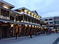
Manila is known for its Art Deco theaters. Some of these were designed by Juan Nakpil and Pablo Antonio. Escolta Street in Binondo has many buildings in Neoclassical and Beaux-Arts styles. Many of these were built during the American colonial period. Many people want to restore Escolta Street, which was once the most important street in the Philippines.

Sadly, almost all of Manila's old buildings from before World War II were destroyed during the Battle of Manila (1945). After the war, new, modern buildings replaced the old ones. Some destroyed buildings, like the Old Legislative Building (now the National Museum of Fine Arts), have been rebuilt. There are plans to fix up and restore other old places like San Sebastian Church. Old Spanish-era shops and houses in Binondo, Quiapo, and San Nicolas are also planned for restoration.
Because Manila often has earthquakes, Spanish architects created a style called Earthquake Baroque. Churches and government buildings used this style to be stronger. This helped Manila survive many earthquakes in the 1700s and 1800s. Today, modern buildings in Manila are designed to withstand strong earthquakes.
People of Manila

In 2020, Manila had 1,846,513 people. This makes it the second most populated city in the Philippines. Manila is also the most densely populated city in the world! In 2015, there were 41,515 people per square kilometer.
Manila has always been a place where people from different backgrounds come together. Since colonial times, people from India, Latin America, and other places have moved to Manila. Over time, many people of Chinese and Spanish descent started to identify as "Filipino."
Manila's population grew a lot after 1903. In the 1960s, Manila became the first Philippine city to have over one million people. The population has stayed around 1.6 million since the 1990s. This is because many people now live in the suburbs, and Manila is already very crowded. Other cities like Quezon City and Caloocan now have more people than Manila.
The main language spoken is Filipino, which is based on the Tagalog language. This Manila version of Tagalog has become the common language across the Philippines, spread by TV and movies. English is also widely used in schools, businesses, and daily life.
A type of Chinese language called Hokkien (or Lan'nang-oe) is spoken by the city's Chinese-Filipino community.
Manila's Economy

Manila is a very important center for money and business in the Philippines. It's a major hub for banking, shopping, transportation, tourism, and real estate. It's also big in new media, advertising, and the legal services.
Manila is ranked 3rd in economic growth in the Philippines. Its economy is the 5th largest in the country.
The Port of Manila is the biggest seaport in the Philippines. It's the main entry point for international shipping to the country.

Many factories in Manila make things like chemicals, textiles, clothing, and electronic goods. Food, drinks, and tobacco products are also made here. Local businesses also prepare raw materials for export, such as rope, plywood, sugar, and coconut oil. The food processing industry is one of the most stable manufacturing sectors in the city.

The Pandacan oil depot stores and distributes oil for major companies like Caltex, Shell, and Petron.
Manila is also a major center for publishing in the Philippines.
Manila's Culture
Museums

As the cultural heart of the Philippines, Manila has many museums. The National Museum Complex in Rizal Park includes the National Museum of Fine Arts, the National Museum of Anthropology, the National Museum of Natural History, and the National Planetarium. You can see Spoliarium, a famous painting by Juan Luna, in this complex.
The city is home to the National Library of the Philippines. This library keeps important books, records, and cultural items of the country. The National Historical Commission of the Philippines has two history museums in the city: the Museo ni Apolinario Mabini – PUP and the Museo ni Jose Rizal – Fort Santiago.

Bahay Tsinoy is a well-known museum that shows the lives of Chinese people and their contributions to Philippine history. The Intramuros Light and Sound Museum tells the story of Filipinos' fight for freedom during the Philippine Revolution. The Metropolitan Museum of Manila displays modern and contemporary art, and shows Filipino arts and culture.
Other museums include the Museo Pambata, which is a children's museum. Plaza San Luis is an outdoor museum with old Spanish-style houses. There are also church museums like the San Agustin Church Museum and the Museo de Intramuros.
Festivals and Holidays

Manila celebrates many holidays. Since most people in the city are Roman Catholic, many festivals are religious. Manila Day is celebrated on June 24. This day marks the city's founding by Spanish explorer Miguel López de Legazpi in 1571. It's a special non-working holiday. Each of the city's neighborhoods (called barangays) also has its own festivals, honoring their patron saints.
Manila also hosts the huge procession of the Feast of the Black Nazarene (Traslacíon). Millions of Catholic followers attend this event every January 9. Other religious festivals include the Feast of Santo Niño in Tondo and Pandacan, held on the third Sunday of January. Non-religious holidays include New Year's Day, National Heroes' Day, and Rizal Day.
Getting Around Manila


One of the most famous ways to get around Manila is by jeepney. These vehicles are based on U.S. army jeeps and have been used since after World War II. Today, the Tamaraw FX also competes with jeepneys. Like buses, jeepneys and Tamaraws follow set routes for a fixed price.
For private rides, you can find many taxicabs. There are also "tricycles" (motorcycles with sidecars) and "trisikads" or "sikads" (bicycles with sidecars). In some areas, motorized pedicabs are popular. Old horse-drawn carriages called calesas are still used as a fun way for tourists to see Binondo and Intramuros. All public transport is privately owned and operated.
The city has two train lines: LRT-1 and LRT-2. These were built starting in the 1970s, making it the first light rail system in Southeast Asia. These train systems are currently being expanded. LRT Line 1 runs along Taft Avenue and Rizal Avenue. LRT Line 2 runs along Claro M. Recto Avenue and Ramon Magsaysay Boulevard.
The main station for the Philippine National Railways is in Manila. One commuter train line runs from Tutuban (Tondo) towards Laguna. The Port of Manila is the main seaport of the Philippines. The Pasig River Ferry Service also offers transportation along the Pasig River. The city is served by the Ninoy Aquino International Airport and Clark International Airport.
In 2006, Forbes magazine called Manila "the world's most congested city." Manila is known for its frequent traffic jams and very high population density.
Images for kids
-
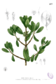
Plate depicting the "nilad" plant (Scyphiphora hydrophylacea), from Augustinian missionary Fray Francisco Manuel Blanco's botanical reference, "Flora de Filipinas"
-
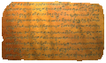
The Laguna Copperplate Inscription is the oldest historical record in the Philippines. It has the first historical reference to Tondo and dates back to Saka 822 (c. 900).
-
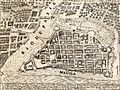
1734 map of the Walled City of Manila. The city was planned according to the Laws of the Indies.
-
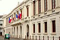
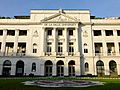
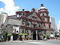
Ayuntamiento de Manila served as the City Hall during the Spanish Colonial Period.
-
Tutuban Main Station, which was built in 1887, is the main terminal of the Ferrocaril de Manila-Dagupan (now known as the Philippine National Railways). At the present moment, it serves as a shopping center and a public transit hub.
-
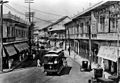
The tranvía running along Escolta Street during the American period.
-
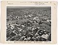
Aerial view of Manila, 1936
-
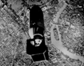
USS Essex TBF-1 Avenger dropping a bomb over Pasig River in Manila targeting the dockyard, November 14, 1944
-
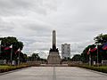
View of the Rizal Monument in Rizal Park.
-

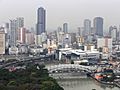
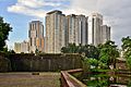
Skyline of Manila as seen from Harbour Square.
-
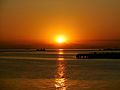
The Manila Bay sunset
-
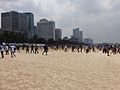
The Manila Bay Beach during the International Coastal Cleanup Day in September 2020
-
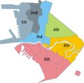
Manila is divided into six congressional districts.
-
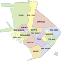
District map of Manila showing its sixteen districts.
-
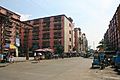
Smog in Quiapo-Binondo area.
-
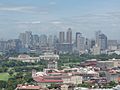
Ermita-Malate skyline in Manila
-
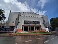
The façade of the NCCA Metropolitan Theater, designed by Filipino architect Juan M. Arellano
-
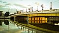
Jones Bridge was redeveloped in 2019 to "restore" it to its near-original design using Beaux-Arts architecture.
-
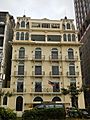
The Luneta Hotel, an example of French Renaissance architecture with Filipino stylized beaux art
-
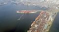
Aerial view of the Port of Manila, the chief port of the Philippines.
-
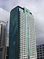
The Bangko Sentral ng Pilipinas, the central bank of the Philippines
-
Skyline of Binondo, the central business district of the city of Manila, as seen from Fort Santiago
-
Landbank Plaza, the headquarters of the Land Bank of the Philippines.
-
The historic Plaza Moriones in Fort Santiago, Intramuros.
-
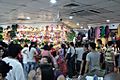
Divisoria is a popular flea market for locals and tourists.
-
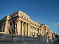
The National Museum of Fine Arts.
-
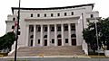
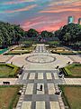
The National Museum of Natural History at Agrifina Circle, Rizal Park.
-
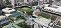
Aerial view of the city-owned Rizal Memorial Sports Complex, considered as the national sports complex of the Philippines.
-
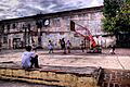
Children playing basketball at the ruins of San Ignacio Church in Intramuros
-
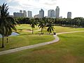
The Intramuros Golf Club
-
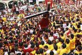
Catholic devotees during the Feast of the Black Nazarene (Traslacíon)
-
Grand Marian Procession in Intramuros
-
The Smokey Mountain Housing Project was built on a former landfill. Continuous development of housing buildings continues up to the present day.
-
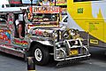
Jeepneys are one of the most popular modes of transportation in Manila
-
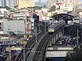
Pureza station of LRT Line 2 in Santa Mesa
-
De La Salle University is a Lasallian educational institution established in 1911.
-
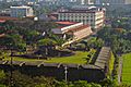
The campus of the University of the City of Manila and Baluarte de San Diego in Intramuros.
-
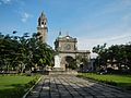
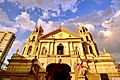
Manila Cathedral is the seat of Roman Catholic Archdiocese of Manila
-
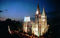
The Minor Basilica of San Sebastián is the only all-steel church in Asia.
-
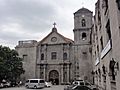
San Agustín Church in Intramuros, a UNESCO World Heritage Site.
-
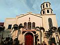
Binondo Church serves the Roman Catholic Chinese community
-
Quiapo Church, home of the iconic Black Nazarene whose Traslacion feast is celebrated every January 9
-
Sto. Niño de Pandacan Church before the 2020 fire


.jpg)

.jpg)


.JPG)
_wiki.jpg)


_(Manila)(2018-02-07).jpg)


_(2014).JPG)
.jpg)
.jpg)


_Facade_-_Front_View.jpg)


(2018-02-22).jpg)


_Manila,_Filipinas..jpg)
.JPG)


.jpg)
See also
 In Spanish: Manila para niños
