
Caloocan facts for kids
Quick facts for kids
Caloocan
Kalookan
|
|||
|---|---|---|---|
|
Highly urbanized city
|
|||
|
Bonifacio Monument
Caloocan City Hall
La Loma Cemetery
Caloocan Cathedral
Caloocan Sports Complex
Thai To Taoist Temple
|
|||
|
|||
| Motto(s):
Aksyon at Malasakit
|
|||
| Anthem: Mabuhay ang Kalookan (Long Live Caloocan) |
|||

Location of Caloocan within Metro Manila
|
|||
|
OpenStreetMap
|
|||
.svg)
Caloocan
Location in Philippines
|
|||
| Country | Philippines | ||
| Region | National Capital Region | ||
| Province | none | ||
| District | [[{{#property:P7938}} | — Lua error in Module:Wd at line 1804: attempt to index field 'wikibase' (a nil value).]] | ||
| Founded | 1815 | ||
| Cityhood | February 16, 1962 | ||
| Highly urbanized city | December 22, 1979 | ||
| Barangays | 193 (see Barangays) | ||
| Government
|
|||
| • Type | Sangguniang Panlungsod | ||
| Area | |||
| • Total | 55.80 km2 (21.54 sq mi) | ||
| Elevation | 30 m (100 ft) | ||
| Highest elevation | 514 m (1,686 ft) | ||
| Lowest elevation | -2 m (−6.6 ft) | ||
| Population
(2020 census)
|
|||
| • Total | 1,661,584 | ||
| • Rank | 4th | ||
| • Density | 29,777.5/km2 (77,123/sq mi) | ||
| • Households | 404,252 | ||
| Economy | |||
| • Income class | 1st city income class | ||
| • Poverty incidence |
|
||
| • Revenue | ₱ 8,006 million (2022) | ||
| • Assets | ₱ 26,513 million (2022) | ||
| • Expenditure | ₱ 5,716 million (2022) | ||
| • Liabilities | ₱ 11,789 million (2022) | ||
| Service provider | |||
| • Electricity | Manila Electric Company (Meralco) | ||
| Time zone | UTC+8 (PST) | ||
| PSGC |
[https://psa.gov.ph/classification/psgc/?q=psgc/barangays/{{#pro000®code={{&provcode=
|
||
| IDD : area code | +63 (0)02 | ||
| Native languages | Tagalog | ||
| Catholic dioceses |
|
||
| Patron saint | St. Roch | ||
| Website | caloocancity |
||
.jpg)
.jpg)


Caloocan, officially known as the City of Caloocan, is a very busy and important city in Metro Manila, Philippines. It is home to 1,661,584 people, making it the fourth most populated city in the Philippines as of the 2020 census.
Caloocan is unique because it's split into two separate parts. This happened because some of its land was given to Quezon City in 1949. It used to be part of the Province of Rizal. Caloocan is also part of the CAMANAVA area, which includes the cities of Malabon, Navotas, and Valenzuela.
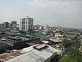
South Caloocan is next to Manila, Quezon City, Malabon, Navotas, and Valenzuela. This part of the city is a major business area with many shops, factories, and homes. North Caloocan borders Quezon City, Valenzuela, and towns in Bulacan and Rizal provinces. This area has mostly homes and large housing developments.
Contents
What's in a Name?
The name "Caloocan" comes from Tagalog words. It might come from lo-ok (meaning "bay"), sulok (meaning "corner"), or kalook-lookan (meaning "innermost area"). The city's name is sometimes spelled Kalookan.
A Look Back at Caloocan's History

Early Beginnings
Caloocan started as a meeting point between the old towns of Tondo and Tambobong. It was near a lagoon called Dagat-Dagatan. People from Tondo who were facing difficulties moved to a stony hill called "Kaloogan," which means "interior territory." This became the new center of the community by 1802.
Caloocan became its own town in 1815, separating from Tondo. Its land stretched far, reaching the foothills of Marikina and San Mateo. A new church was built facing the town hall. In the late 1800s, a steam train line connected Caloocan to Manila and nearby coastal towns.
The Philippine Revolution
Caloocan is very important in Philippine history. It was the main meeting place for the Katipunan, a secret group that started the Philippine Revolution against Spanish rule. Andrés Bonifacio and his group held secret meetings here. The first fight between the Katipunan and the Spanish happened near Caloocan. The revolution officially began after the "Cry of Balintawak" on August 30, 1896.
American and Japanese Eras
In 1899, the people of Caloocan resisted the American forces who wanted to take control of the country. There was heavy fighting in the Philippine–American War. In 1901, Caloocan became a municipality of the new Rizal province. Later, in 1903, the town of Novaliches joined Caloocan.
During World War II, in 1942, Caloocan was temporarily merged with Manila and Quezon City to form the City of Greater Manila. After the war, in 1945, it went back to being a municipality of Rizal.
Becoming a City

Caloocan officially became a city on February 16, 1962. It remained part of Rizal province until November 7, 1975, when it became part of Metro Manila.
Changes in City Borders
Caloocan used to be much larger. Areas like Balintawak, La Loma, and Novaliches were once part of it. Balintawak is famous as the original site of the "Cry of Pugad Lawin." Novaliches had hills that served as hiding places for the Katipunan.
Over time, parts of Caloocan were given to Quezon City. In 1939, when Quezon City was created, Caloocan gave up 1,500 hectares of land. In 1949, another law changed the boundary, and more areas, including much of Novaliches, were separated from Caloocan. This split Caloocan into the two parts we see today: a busy southern part and a more residential northern part.
In 2024, Bagong Silang (Barangay 176), which was the country's most populated barangay, was divided into six smaller barangays to better serve its many residents.
City's Efforts to Address Challenges
The city government has worked to improve safety and address social issues. For example, in 2017, the Caloocan Anti-Drug Abuse Office (CADAO) was created to help with rehabilitation and prevention programs. The city also passed a curfew for minors to help keep young people safe. The city's police force has undergone changes to improve its services.
Caloocan's Geography
Caloocan is divided into two parts. South Caloocan is about 13.6 square kilometers. North Caloocan is larger, at about 39.7 square kilometers.
Land Features

South Caloocan is mostly flat, which is why many businesses are located there. North Caloocan has more varied land, with some gently sloping hills. Many homes and industrial areas have been built on this land.
The soil in Caloocan is mostly reddish-brown and is good for building.
Waterways
Caloocan has natural creeks and rivers, as well as man-made drainage canals. These help remove excess water from the land. Important rivers include the Tinajeros-Tullahan River and the Meycauayan-Marilao River. Many smaller creeks also flow through the city.
Weather in Caloocan
| Climate data for Caloocan | |||||||||||||
|---|---|---|---|---|---|---|---|---|---|---|---|---|---|
| Month | Jan | Feb | Mar | Apr | May | Jun | Jul | Aug | Sep | Oct | Nov | Dec | Year |
| Mean daily maximum °C (°F) | 29 (84) |
30 (86) |
32 (90) |
34 (93) |
33 (91) |
31 (88) |
30 (86) |
29 (84) |
29 (84) |
30 (86) |
30 (86) |
29 (84) |
31 (87) |
| Mean daily minimum °C (°F) | 20 (68) |
20 (68) |
21 (70) |
23 (73) |
24 (75) |
25 (77) |
24 (75) |
24 (75) |
24 (75) |
23 (73) |
22 (72) |
21 (70) |
23 (73) |
| Average precipitation mm (inches) | 7 (0.3) |
7 (0.3) |
9 (0.4) |
21 (0.8) |
101 (4.0) |
152 (6.0) |
188 (7.4) |
170 (6.7) |
159 (6.3) |
115 (4.5) |
47 (1.9) |
29 (1.1) |
1,005 (39.7) |
| Average rainy days | 3.3 | 3.5 | 11.1 | 8.1 | 18.9 | 23.5 | 26.4 | 25.5 | 24.5 | 19.6 | 10.4 | 6.4 | 181.2 |
| Source: Meteoblue | |||||||||||||
City Divisions: Barangays


Caloocan has 193 barangays, which are like small neighborhoods or villages. These are grouped into three main districts. Most barangays have numbers, but some, especially in North Caloocan, also have names.
Before 2024, Barangay 176, also known as Bagong Silang, was the largest barangay in the entire country by population. It had over 261,000 people! Because it was so big, it was divided into six smaller barangays in August 2024 to make it easier to manage.
On the other hand, Barangay 76 is the smallest barangay in Metro Manila, with only two residents.
Caloocan's Economy
_Market,_Caloocan,_Jun_2024.jpg)
Caloocan is a busy city with a strong economy. It ranks high among cities in the Philippines for its economic activity.
The 10th Avenue area is famous for its many motorcycle shops and spare parts dealers.


You can find many shopping malls and supermarkets in Caloocan. In the southern part, there's SM City Grand Central, Victory Central Mall, and SM Center Sangandaan. In the northern part, you'll find Zabarte Town Center and SM City Caloocan.
Many factories and industrial areas are also located here, especially in the northern parts like Bagumbong and Tala. Tala is even home to a special economic zone called Victoria Wave.
Major expressways like the North Luzon Expressway and its extensions, NLEX Harbor Link and NLEX Connector, pass through Caloocan, making it an important hub for transportation and business.
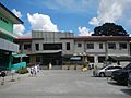
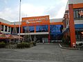
City Government
.jpg)
.jpg)
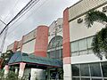
Like other cities in the Philippines, Caloocan has its own local government. The city is led by a mayor, who handles the city's daily operations, and a vice mayor, who leads the city council. The city council is made up of eighteen councilors, six from each of the city's three districts. Caloocan also has three representatives in the country's House of Representatives.
The main Caloocan City Hall is in Grace Park East. There is also a Caloocan City Hall North in Camarin, which serves the northern part of the city.
Getting Around Caloocan


Caloocan has a good transportation system. The LRT Line 1 train has two stations in the southern part of the city: Monumento and 5th Avenue. The Philippine National Railways (PNR) also has train stations in Caloocan.
Major roads like Epifanio de los Santos Avenue start in the Monumento area. The North Luzon Expressway also has its main operations center and a toll barrier in Caloocan. New expressways like NLEX Harbor Link and NLEX Connector also pass through the city, connecting it to other important areas.
Famous Places and Landmarks

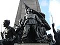
The most famous landmark in Caloocan is the monument dedicated to Andrés Bonifacio, a hero of the Philippine Revolution. This monument stands where several major roads meet and marks the site of the first battle of the Philippine Revolution in 1896. The area around it is known as 'Monumento'.
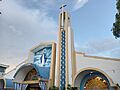
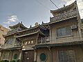
Other important historical sites include a lot on P. Zamora Street where Bonifacio's wife once lived, the old house of Gertrudes Sevilla, Santa Quiteria Church, Our Lady of Grace Parish, and La Loma Cemetery, which is the oldest cemetery in Manila. The Thai To Taoist Temple is also a notable landmark.
Education in Caloocan

Caloocan has many schools for students of all ages. The city's public university is the University of Caloocan City. Other colleges include University of the East Caloocan and Manila Central University.
For younger students, there are many public and private schools. Some notable public high schools are Caloocan National Science and Technology High School and Caloocan City Science High School. Private schools like Philippine Cultural College (Annex) and St. Mary's Academy of Caloocan City also provide education in the city.
Sister Cities
Caloocan has friendly relationships with other cities, both locally and internationally.
Local Sister Cities
- Calamba, Laguna
- Malabon, Metro Manila
- San Jose del Monte, Bulacan
International Sister City
Images for kids
-
Bonifacio Monument
-
Shrine of Our Lady of Grace
-
Sto. Niño de Bagong Silang Church
-
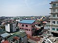
View of Grace Park from the new city hall
-
View of Barangays 15 and 16 from the old city hall
-
Caloocan Judicial Complex
-
Ung Siu Si Buddhist Temple
-
Schools Division Office of Caloocan
-
Dr. Jose N. Rodriguez Memorial Hospital in Tala
-
Kalookan Cockpit Arena in Kaybiga
-
Glorieta Park
-
Caloocan City North Medical Center in Camarin


See also
 In Spanish: Caloocan para niños
