
Chuuk Lagoon facts for kids
Quick facts for kids
Chuuk Lagoon
|
||
|---|---|---|
|
Atoll
|
||
|
||
| Country | ||
| State | Chuuk State | |
| Capital | Weno | |
| Area | ||
| • Total | 93.07 km2 (35.93 sq mi) | |
| Elevation | 443 m (1,453 ft) | |
| Population
(2010)
|
||
| • Total | 36,158 | |
| • Density | 388.503/km2 (1,006.22/sq mi) | |


.JPG)
Chuuk Lagoon, also known as Truk Atoll, is a beautiful group of islands in the central Pacific Ocean. It is like a big ring-shaped coral reef with many islands inside. This forms a natural harbor, which is a safe place for ships.
Chuuk Lagoon is about 1,800 kilometers (1,100 miles) northeast of New Guinea. It is part of Chuuk State within the Federated States of Micronesia. A large reef, 225 kilometers (140 miles) around, protects the lagoon. The lagoon itself is about 79 by 50 kilometers (49 by 31 miles) wide. The land area of the islands is about 93 square kilometers (36 square miles). About 36,158 people live here.
Weno city, on Moen Island, is the capital of Chuuk Atoll. It is also the capital of Chuuk State and the largest city in the Federated States of Micronesia. About 13,700 people live in Weno. During World War II, Chuuk Lagoon was a very important naval base for Japan. It was attacked by the United States in 1944.
Contents
What's in a Name?
The name Chuuk means mountain in the local Chuukese language. For a long time, people called it Truk. This was a slightly different way of saying its old name, Ruk. In 1990, it officially went back to being called Chuuk. Other old names for the lagoon included Hogoleu, Torres, Ugulat, and Lugulus.
Where is Chuuk Lagoon?
Chuuk Lagoon is part of a bigger group of islands called the Caroline Islands. It has eleven main islands and many smaller ones. These islands are inside a large lagoon, which is a calm body of water protected by a coral reef. Chuuk is part of the Federated States of Micronesia in the Pacific Ocean.
Main Islands of Chuuk
Here is a list of the main islands, their villages, and how many people lived there in 2010:
| Island | Capital | Other Cities | Area (km2) | Population |
|---|---|---|---|---|
| Chuuk Atoll | 93.07 | 36158 | ||
| Faichuk | 41.8 | 11305 | ||
| Fanapanges | Nepitiw | Peniamwan, Wichuk, Seisein, Sapotiw | 1.62 | 672 |
| Paata | Sapaata | Chukufefin, Nukaf, Epin, Pokochou, Etlemar, Onas Point | 4.4 | 1107 |
| Polle | Nepanonong | Chukaram, Neton, Malaio, Unikappi, Sapou, Miari, Neirenom | 9.3 | 1496 |
| Ramanum | Winisi | Chorong, Nepor Point | 0.856 | 865 |
| Tol | Foson | Chukienu, Wichukuno, Wonip, Nechocho, Munien, Faro, Winifei, Foupo, Foup | 10.3 | 4579 |
| Udot | Fanomo | Tunuk, Wonip, Ounechen, Monowe, Chukisenuk, Mwanitiw, Penia | 4.5 | 1680 |
| Onei | Nambo | Onnap, Fanato, Nepos, Peniata, Sapitiw, Anakun, Tolokas, Ras | 10 | 638 |
| Northern Namoneas | Weno | Neiwe, Mwan, Nepukos, Iras, Mechitiw, Tunuk, Peniesene, Penia, Wichap | 20.76 | 14620 |
| Fono | Fanip | Mesor | 0.342 | 388 |
| Piis | Nukan | Sapatiw | 0.32 | 360 |
| Weno | Weno | Neiwe, Mwan, Nepukos, Iras, Mechitiw, Tunuk, Peniesene, Penia, Wichap | 19.1 | 13854 |
| Southern Namoneas | 30.42 | 10233 | ||
| Fefan | Messa | Sapota, Aun, Sapore, Upwein, Fason, Wininis, Pieis, Ununo, Fongen, Onongoch, Feini, Mwen, Saporanong, Manukun, Meseiku, Kukuwu, Sopuo | 12.15 | 3471 |
| Tonowas | Nemuanon | Pwene, Chun, Nechap, Tonof, Pata, wonpiepi, Meseran, Fankachau, Sapou, Roro, Penior, Nukanap, Penienuk, Saponong, Supun, Nukan | 8.94 | 3294 |
| Uman Island | Nepononong | Sapou, Nepon, Sapotiw, Sapota, Nesarau, Sanuk, Mochon, Nukan, Manukun | 3.86 | 2540 |
Weather in Chuuk
Chuuk Lagoon has a warm, tropical climate all year round. It often rains, keeping the islands green and lush.
| Climate data for Chuuk Islands | |||||||||||||
|---|---|---|---|---|---|---|---|---|---|---|---|---|---|
| Month | Jan | Feb | Mar | Apr | May | Jun | Jul | Aug | Sep | Oct | Nov | Dec | Year |
| Mean daily maximum °C (°F) | 30 (86) |
30 (86) |
30 (86) |
31 (87) |
31 (87) |
31 (87) |
31 (87) |
31 (87) |
31 (87) |
31 (87) |
31 (87) |
30 (86) |
31 (87) |
| Mean daily minimum °C (°F) | 25 (77) |
25 (77) |
25 (77) |
25 (77) |
25 (77) |
24 (76) |
24 (76) |
24 (75) |
24 (76) |
24 (76) |
24 (76) |
25 (77) |
24 (76) |
| Average precipitation mm (inches) | 230 (8.9) |
170 (6.7) |
220 (8.8) |
310 (12.3) |
360 (14.3) |
300 (12) |
350 (13.7) |
350 (13.9) |
320 (12.6) |
350 (13.6) |
290 (11.3) |
310 (12.1) |
3,560 (140.3) |
| Source: Weatherbase | |||||||||||||
A Look at History
.jpg)

Early Settlements
We don't know exactly when people first settled on the islands of Chuuk. But old findings show that people lived on Feefen and Wééné Islands around 100 or 200 BC. More signs of people living there appeared around the 1300s AD.
European Visitors and Control
The first Europeans to see Chuuk were led by a Spanish explorer named Álvaro de Saavedra Cerón in 1528. Later, another Spaniard, Alonso de Arellano, visited in 1565.
Spain claimed Chuuk as part of the Caroline Islands in the late 1800s. At that time, different tribes on Chuuk often fought each other. There were also a few foreign traders and missionaries. Spain's control was not very strong. They tried to make peace between the tribes in 1895, but they never built a lasting settlement. The fighting continued until Germany took over.
In 1899, Spain sold the Caroline Islands to the German Empire. This happened after Spain lost the Spanish–American War.
During World War I, Japan took control of German islands in the Pacific, including Chuuk. After Germany lost the war, Japan was given control of Chuuk by the League of Nations.
Chuuk in World War II

During World War II, Truk Lagoon became Japan's most important naval base in the South Pacific. It was a very strong base for Japanese ships and planes fighting against the Allied forces. The Japanese built many roads, bunkers, and caves on the islands. They also built five airstrips, bases for seaplanes, and repair shops for submarines.
The Japanese had over 44,000 soldiers and sailors stationed at Truk. Because of its strong defenses, both natural and man-made, the Allies called Truk "the Gibraltar of the Pacific." Many important Japanese warships, like the battleships Yamato and Musashi, were based here. Some people even called Truk Japan's version of America's Pearl Harbor.
In 1944, Truk's power as a naval base was destroyed by a huge air attack. Japan had moved its largest warships away a week before the attack. But on February 17, 1944, American planes launched Operation Hailstone. This attack lasted for three days. American planes sank 12 smaller Japanese warships and 32 merchant ships. They also destroyed 275 Japanese aircraft, mostly on the ground. This attack made "Truk Lagoon the biggest graveyard of ships in the world."
The attacks greatly reduced Truk's threat to the Allies. Japanese forces on other islands were cut off from supplies. Truk was then isolated as Allied forces moved closer to Japan. British and Canadian forces attacked it again in June 1945. The Japanese forces on Chuuk ran out of food and faced starvation before Japan surrendered in August 1945.
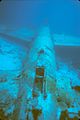
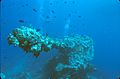
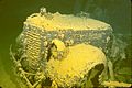
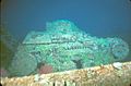
Diving into History


In 1969, a famous French ocean explorer named Jacques Cousteau and his team explored Truk Lagoon. After his TV show in 1971, the atoll became a popular place for scuba diving. Divers from all over the world come to see the many sunken ships. These shipwrecks are sometimes called the "Ghost Fleet of Truk Lagoon."
Many of the shipwrecks are in clear water, less than 15 meters (50 feet) deep. Divers can swim over decks where gas masks and depth charges are still found. Inside the ships, you can see old fighter planes, tanks, bulldozers, motorcycles, and thousands of other items. One special wreck is the submarine I-169 Shinohara. It sank while trying to avoid bombing and had been part of the attack on Pearl Harbor.
The wrecks are now covered in coral and attract many kinds of sea life. You can see manta rays, turtles, sharks, and colorful corals. Scientists have found over 266 types of reef fish here.
There is a concern about oil leaking from the old Japanese warships. Environmental groups are working to find out how much oil is still in the sunken ships. They are also working with Japanese researchers to plan a clean-up. The ships are considered Japanese war graves, so the Japanese government is involved in the clean-up efforts.
Life and Travel in Chuuk

Many roads and transportation systems in Chuuk need repair. A big plan has started to rebuild the sewer, water, and road systems. This project began in 2009.
Getting around by taxi usually costs one or two dollars. A drive from the airport to a resort might take about 35 minutes, even if it's less than 5 miles away. Chuuk International Airport is on Moen Island. You can fly there with United Airlines.
The state government runs a radio station. People often use citizen's band radio to talk between islands. Phone service is limited, but there is a cellular network on some islands. High-speed internet became available on Moen Island in 2010.
Tourism is the main industry in Chuuk, especially scuba diving to see the many shipwrecks. Many divers stay on live-aboard boats to explore the lagoon. Copra, which is dried coconut meat, is the only main crop sold. Most people on the outer islands grow food for themselves and their families.
Images for kids
-
Mitsubishi "Betty" bomber
-
Bow gun of the Fujikawa Maru
-
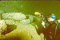
1940's truck in the hold of the Hoki Maru
-
2-man tank on the deck of the Nippo Maru
-
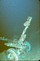
Light artillery piece on the deck of the Nippo Maru
-
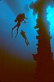
Divers next to the mast of the Unkai Maru
-
Diver photographing 14-inch artillery shells in the Yamagiri Maru
-
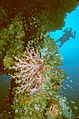
Diver and soft corals next to the mast of the Hoki Maru
-
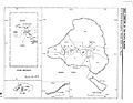
Administrative subdivision of Chuuk Lagoon


See also
 In Spanish: Islas Chuuk para niños
