Farallon de Pajaros facts for kids

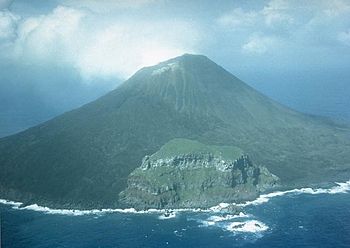
view of Farallón de Pájaros
|
|
 |
|
| Geography | |
|---|---|
| Location | Pacific Ocean |
| Coordinates | 20°32′42″N 144°53′37″E / 20.54500°N 144.89361°E |
| Archipelago | Mariana Islands |
| Area | 2.2 km2 (0.85 sq mi) |
| Length | 1.8 km (1.12 mi) |
| Width | 1.6 km (0.99 mi) |
| Highest elevation | 360 m (1,180 ft) |
| Highest point | Farallon de Pajaros |
| Administration | |
|
United States
|
|
| Commonwealth | Northern Mariana Islands |
| Demographics | |
| Population | - uninhabited - (2010) |
Farallón de Pájaros (say "Fa-ra-YON day PAH-ha-ros") is a small, uninhabited volcanic island. Its name comes from Spanish and means "Birds' Rock." It is also known as Uracus or Urracas, meaning "Magpies." This island is the northernmost one in the Northern Mariana Islands chain, located in the Pacific Ocean. It covers about 2.3 square kilometers (0.9 square miles).
Contents
Island History and Ownership
Farallón de Pájaros has been controlled by different countries over time. From 1899 to 1914, the German Empire ruled the island. They managed it as part of their colony called German New Guinea. In 1903, a Japanese company rented the island. They hunted birds there for their feathers, which were sent to Japan and then to Paris.
After World War I, the island was given to the Empire of Japan. This was decided by the League of Nations, an organization that promoted world peace. The island became part of Japan's South Seas Mandate.
After World War II, Farallón de Pájaros was given to the United States. It became part of the UN Trust Territory of the Pacific Islands. Today, the island is part of the Northern Islands Municipality in the Commonwealth of the Northern Mariana Islands.
In 1985, the island was made a special wilderness area. This was done to protect its natural resources. Since 2009, Farallón de Pájaros has been part of the Marianas Trench Marine National Monument. This monument helps protect the ocean and islands around it.
Exploring the Island's Geography
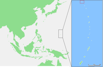
Farallón de Pájaros is the northernmost island in the Mariana Islands chain. It is about 65 kilometers (40 miles) northwest of the Maug Islands. It is also about 591 kilometers (367 miles) north of Saipan, which is the main island of the Northern Mariana Islands. The closest land to its north is South Iwo Jima in Japan, about 541 kilometers (336 miles) away.
The island is almost perfectly round. It is about 1.8 kilometers (1.1 miles) long and 1.6 kilometers (1.0 miles) wide. Its total area is about 2.3 square kilometers (0.9 square miles). Farallón de Pájaros is actually the top of an active stratovolcano. A stratovolcano is a tall, cone-shaped volcano built up by many layers of hardened lava and ash. The island's highest point is 360 meters (1,180 feet) above sea level. The base of this huge volcano is about 2,000 feet (610 meters) below the ocean surface. It has a diameter of 15 to 20 kilometers (9 to 12 miles).
Volcanic Activity and Underwater Volcanoes
Farallón de Pájaros is an active volcano. Between 1864 and 1953, people recorded 15 volcanic eruptions from the island.
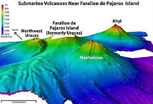
There are also two underwater volcanoes near Farallón de Pájaros. The Makhahnas Seamount is about 10 kilometers (6 miles) southwest. It reaches a height of 640 meters (2,100 feet) below sea level. Its last known eruption was in 1967.
The Ahyi Seamount is about 18 kilometers (11 miles) southeast. It reaches a height of 137 meters (449 feet) below sea level. This seamount might have erupted in 1979 and definitely erupted in 2001. From April 24 to May 17, 2014, it had a series of underwater eruptions. Hot water activity continued there until at least December 2014.
Important Bird Area for Wildlife
Farallón de Pájaros is recognized as an Important Bird Area (IBA) by BirdLife International. This means it is a very important place for birds. The island provides a home for populations of Micronesian megapodes and sooty terns. These birds rely on the island for nesting and living.
See also
 In Spanish: Farallón de Pájaros para niños
 | John T. Biggers |
 | Thomas Blackshear |
 | Mark Bradford |
 | Beverly Buchanan |


