
Maug Islands facts for kids

US Geological survey photo of Maug islands
|
|
 |
|
| Geography | |
|---|---|
| Location | Pacific Ocean |
| Coordinates | 20°2′N 145°13′E / 20.033°N 145.217°E |
| Archipelago | Northern Mariana Islands |
| Area | 2.14 km2 (0.83 sq mi) |
| Highest elevation | 227 m (745 ft) |
| Highest point | North Island |
| Administration | |
|
United States
|
|
| Commonwealth | Northern Mariana Islands |
| Demographics | |
| Population | - uninhabited - (2010) |
The Maug Islands are a group of three small islands in the Pacific Ocean. Their name comes from the Chamorro language word Ma'ok, which means "steadfast" or "everlasting". These islands are part of the Northern Mariana Islands and currently, no one lives on them.
Contents
What Are the Maug Islands Like?

The Maug Islands are located about 70 kilometers (43 miles) south of Farallon de Pajaros. They are also about 37 kilometers (23 miles) north of Asuncion Island. These three islands are actually the outer edges of a huge underwater volcano.
This volcano has a large sunken area called a caldera, which is about 2.2 kilometers (1.4 miles) wide. The bottom of this caldera is about 225 meters (738 feet) below sea level. In the middle of the caldera, there's an underwater mountain. Its top is only 22 meters (72 feet) below the surface.
The total land area of all three islands together is 2.13 square kilometers (0.82 square miles). The highest point on the islands is 227 meters (745 feet) above sea level. About 10 kilometers (6 miles) northwest of the Maug Islands is Supply Reef. This is another underwater volcano, and its peak is 8 meters (26 feet) below sea level. The Maug Islands and Supply Reef are connected underwater. They are part of the same large volcanic structure.
How Big Are the Maug Islands?
Here is a table showing the size of each island:
| Island | Length (km) | Width (km) | Area (km²) | Height (m) |
|---|---|---|---|---|
| North Island | 1.5 | 0.5 | 0.47 | 227 |
| East Island | 2.25 | 0.5 | 0.95 | 215 |
| West Island | 2.0 | 0.75 | 0.71 | 178 |
| Maug Islands | 3.1 | 3.0 | 2.13 | 227 |
Nature and Wildlife
The Maug Islands are mostly covered in savannah grass. On East Island, you can find Pandanus trees and coconut palms. These plants grow near where a small settlement used to be.
Why Are the Maug Islands Important for Birds?
The Maug Islands are a special place for birds. BirdLife International has called them an Important Bird Area (IBA). This means the islands are crucial for many bird species.
Birds that live here include Micronesian megapodes and red-tailed tropicbirds. You can also find brown noddies, Micronesian myzomelas, and Micronesian starlings. Protecting these islands helps these bird populations survive.
History of the Maug Islands
The Maug Islands were first seen by Europeans on August 22, 1522. A Spanish explorer named Gonzalo Gómez de Espinosa discovered them. He was part of Ferdinand Magellan's journey around the world. Espinosa named the islands Las Monjas, which means "The Nuns" in Spanish.
When Gómez de Espinosa arrived, Chamorros lived on the largest Maug Island. They called the island Mao or Pamo. Espinosa had taken some Chamorro people from Agrihan and set them free here. Three of his crew members also left their ship, the Trinidad, on the island. Two of them were killed by the Chamorros. The third, Gonzalo Alvarez de Vigo, later made it to Guam.
In 1669, a Spanish missionary named Diego Luis de San Vitores visited the islands. He renamed them San Lorenzo (St. Lawrence). By 1695, all the Chamorro people living on the islands were forced to move to Saipan. Three years later, they were moved again to Guam. Since then, the Maug Islands have been uninhabited.
Who Owned the Islands Over Time?
In 1899, Spain sold the Northern Marianas to the German Empire. The Maug Islands then became part of German New Guinea. In 1903, a Japanese company leased the islands. They hunted birds there to collect feathers, which were sold in Japan and then in Paris.
During World War I, the Empire of Japan took control of the Maug Islands. They were then managed as part of the South Seas Mandate. The Japanese built a weather station on the islands. They also had a fish processing plant there.
During World War II, a German ship called the Orion met with supply ships in the Maug Islands' caldera. This happened in January and February of 1941.
After World War II, the United States took control of the islands. They were managed as part of the Trust Territory of the Pacific Islands. Since 1978, the Maug Islands have been part of the Northern Islands Municipality. This municipality is part of the Commonwealth of the Northern Mariana Islands.
In 1985, the islands were made a wilderness area. This was done to protect their natural resources. Since 2009, the waters and land around the islands have been part of the Marianas Trench Marine National Monument. This monument is managed by the United States.
Images for kids
-
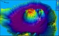
Perspective view of central cone within caldera. Colors indicate depth.
-
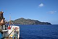
Maug's East Island taken from USCGC Sequoia.
-
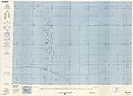
Map including the Maug Islands (DMA, 1983)


See also
 In Spanish: Islas Maug para niños
