
Asuncion Island facts for kids

US Geological survey photo of Asuncion island
|
|
 |
|
| Geography | |
|---|---|
| Location | Pacific Ocean |
| Coordinates | 19°41′33″N 145°24′13″E / 19.69250°N 145.40361°E |
| Archipelago | Northern Mariana Islands |
| Area | 7.86 km2 (3.03 sq mi) |
| Length | 3.3 km (2.05 mi) |
| Width | 3 km (1.9 mi) |
| Highest elevation | 857 m (2,812 ft) |
| Highest point | Mount Asuncion |
| Administration | |
|
United States
|
|
| Commonwealth | Northern Mariana Islands |
| Demographics | |
| Population | 0 (2010) |
Asuncion Island, also known as Ascuncion, gets its name from a Spanish word meaning "ascension." It is the third-most northern island in the Northern Mariana Islands, a group of islands in the Pacific Ocean. No one lives on Asuncion Island.
The island is located about 101 kilometers (63 miles) northwest of Agrihan. It is also about 37 kilometers (23 miles) southeast of the Maug Islands.
Contents
History of Asuncion Island
From a European point of view, the Spanish missionary Diego Luis de San Vitores first officially found Asuncion in 1669. He gave it its current name, which means "Assumption of Mary" in Spanish.
However, it's possible that a Spanish sailor named Gonzalo de Vigo visited the island earlier in 1522. He was a sailor who left the Magellan expedition in 1521. He was also the first European castaway (someone shipwrecked) in the Pacific Ocean's history.
In 1695, the native Chamorros who lived on the island were moved to Saipan. Three years later, they were moved again to Guam.
German and Japanese Control
In 1899, Spain sold the Northern Marianas to the German Empire. Asuncion then became part of German New Guinea. In 1903, a Japanese company rented the island. They hunted birds there to collect their feathers. These feathers were sent to Japan and then to Paris. Sadly, six Japanese hunters died on the island in 1910 due to illness.
During World War I, Japan took control of Asuncion. After that, it was managed as part of the South Seas Mandate.
Under United States Control
After World War II, the United States took control of the island. It was managed as part of the Trust Territory of the Pacific Islands. Since 1978, Asuncion has been part of the Northern Islands Municipality. This is a part of the Commonwealth of the Northern Mariana Islands.
In 1985, the island was made a special wilderness area. This was done to protect its natural plants and animals. Since 2009, Asuncion Island has been part of the Marianas Trench Marine National Monument of the United States. This monument helps protect the ocean and islands in the area.
Geography of Asuncion Island
Asuncion is an island covered in thick forests. It is shaped like an oval. The island is about 3.3 kilometers (2.1 miles) long and 3 kilometers (1.9 miles) wide. Its total area is about 7.9 square kilometers (3.1 square miles).
The entire island is a huge stratovolcano. This type of volcano is tall and cone-shaped, built up by many layers of hardened lava and ash. It rises from the ocean floor to a height of 857 meters (2,812 feet) above sea level. The last time this volcano erupted was in 1906.
The volcano is not perfectly even. Its northeast slopes are very steep and end in high cliffs. The southwestern slopes are not as steep and meet the sea with lower cliffs. The coastlines around the island are mostly rocky.
Plants on the Island
The plants on Asuncion Island include:
- Miscanthus floridulus grasslands on the higher parts of the slopes.
- Forests of Coconut Palm trees (Cocos nucifera) on the lower slopes.
- Some Pandanus trees.
- Papaya plants (Carica papaya).
- Native Pisonia trees.
Important Bird Area
BirdLife International has named Asuncion Island an Important Bird Area (IBA). This means it's a very important place for birds. The island is home to several special bird populations, including:
- Micronesian megapodes
- White-throated ground doves
- Micronesian myzomelas
- Micronesian starlings
Images for kids
-
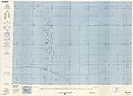
Map showing Asuncion Island (1983)
-
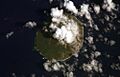
Asuncion Island from space


See also
 In Spanish: Isla Asunción para niños
