
Sarigan facts for kids

Sarigan from the east
|
|
 |
|
| Geography | |
|---|---|
| Location | Pacific Ocean |
| Coordinates | 16°42′N 145°47′E / 16.700°N 145.783°E |
| Archipelago | Northern Mariana Islands |
| Area | 4.9 km2 (1.9 sq mi) |
| Length | 2.7 km (1.68 mi) |
| Width | 2.5 km (1.55 mi) |
| Highest elevation | 538 m (1,765 ft) |
| Administration | |
|
United States
|
|
| Commonwealth | Northern Mariana Islands |
| Demographics | |
| Population | - uninhabited - (2010) |

Sarigan is a volcanic island in the Pacific Ocean. No one lives on it. It is part of the Northern Mariana Islands, which is a U.S. territory. Sarigan is about 37 kilometers (23 miles) northeast of Anatahan island. It is also 67 kilometers (42 miles) south of Guguan and 150 kilometers (93 miles) north of Saipan. Saipan is the biggest island in the Northern Marianas.
Contents
History of Sarigan Island
Early Life and European Discovery
The Chamorro people were the first to live on Sarigan. A Spanish explorer named Bernardo de la Torre was the first European to find Sarigan. He discovered the island in October 1543. In 1695, the native people were made to move to Saipan. Three years later, they were moved again to Guam.
German and Japanese Control
Spain sold the Northern Marianas to the German Empire in 1899. Sarigan then became part of German New Guinea. From 1900 to 1906, the island was used as a penal colony. This means it was a place where prisoners were sent. These prisoners often lived with their families. They mainly worked on coconut farms.
In 1909, a company called the Pagan Society leased the island. This company was a mix of German and Japanese owners. They kept exporting copra, which is dried coconut meat. They also hired people to hunt birds for their feathers. These feathers were sent to Japan and Europe. But the Pagan Society started having money problems in 1912.
During World War I, Japan took control of Sarigan. It then became part of the South Seas Mandate. In the 1930s, about 10 to 20 families lived on the island.
Under United States Control
After World War II, the United States took control of the island. The people living there were moved away. By 1947, Sarigan was part of the Trust Territory of the Pacific Islands. Since 1978, it has been part of the Northern Islands Municipality. This is a part of the Commonwealth of the Northern Mariana Islands.
Sarigan Today: A Nature Preserve
Today, Sarigan is a nature preserve. This means it is a protected area for plants and animals. In the mid-1990s, a project started to remove wild animals from Sarigan. Now, only a few cats are left. People have suggested moving endangered birds from Guam and Saipan to Sarigan.
On May 28, 2010, a submarine volcano erupted. This volcano is about 7 kilometers (4 miles) south of Sarigan. It sent out a cloud of steam and ash. The cloud went up to 15,000 meters (49,000 feet) high. It also left pumice (lightweight volcanic rock) floating on the water. After this eruption, the government said no one could go to Sarigan.
Geography of Sarigan

Sarigan is shaped like a triangle. It is about 2.7 kilometers (1.7 miles) long and 2.5 kilometers (1.6 miles) wide. Its total area is about 4.5 square kilometers (1.7 square miles). The island is actually the top of a stratovolcano. This volcano rises to 494 meters (1,621 feet) above sea level.
The volcano has a large bowl-shaped top called a caldera. This caldera is 750 meters (2,460 feet) across. Inside it, there is an ash cone and two lava domes. These domes produced lava flows that reached the coast. No eruptions have been recorded in history. However, many earthquakes happened here in the summer of 2005. These earthquakes were caused by the volcano.
Island Landscape and Landing Challenges
It is hard to land on Sarigan. This is because steep cliffs surround most of the island. It has many ravines and valleys. These areas have thick tropical vegetation, especially on the north side. The stratovolcano is at the southern end of the island. North of it, there is a flat area called a plateau. This plateau is 322 meters (1,056 feet) high and 0.42 kilometers (0.26 miles) wide. North of the plateau, there are steep, green slopes that go down to the sea.
The northwest coast of the island is the easiest place to live. It rises from sea level to 61 meters (200 feet) in just 0.24 kilometers (0.15 miles). This area also has a lot of plants.
About 12 kilometers (7.5 miles) south of Sarigan is the South Sarigan Seamount. This is a submarine volcano (a volcano under the sea). It has several peaks, with the highest being 184 meters (604 feet) below sea level. In May 2010, it briefly erupted. It sent a plume of water vapor about 12 kilometers (7.5 miles) high.
Important Bird Area
BirdLife International has named Sarigan an Important Bird Area (IBA). This means it is a special place for birds. The island is home to several types of birds, including:
- Micronesian megapodes
- White-throated ground doves
- Micronesian myzomelas
- Micronesian starlings
Images for kids
-
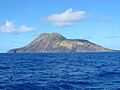
Sarigan from the east
-
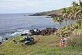
A biological survey party lands on Sarigan, 2010. Photo courtesy Michael Lusk.
-
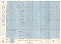
Map showing Sarigan (1983)
See also
 In Spanish: Sarigan para niños
