Plateau facts for kids

A plateau is a large area of flat land that is much higher than the land around it. Think of it like a giant, flat-topped table in nature! Plateaus are also called high plains or tablelands. They often have steep sides, rising sharply from the surrounding areas. Plateaus can be formed in different ways, like when hot rock from inside the Earth pushes up the ground, or when lava spreads out, or even when water and ice wear away mountains.
Contents
How Plateaus Are Formed
Plateaus can be created by several natural processes. These include hot rock pushing up from deep inside the Earth, lava flowing out and hardening, and the wearing away of land by water and glaciers.
Volcanic Plateaus

Volcanic plateaus are made by volcanic activity. A good example is the Columbia Plateau in the northwestern United States.
One way volcanic plateaus form is when hot, melted rock called magma rises from the Earth's mantle. This magma pushes the ground upward, lifting large, flat areas of rock to create a plateau. Another way is when lava (magma that has reached the surface) flows out from cracks in the Earth's crust. This lava spreads out in layers, building up to form a plateau.
Plateaus Formed by Erosion
Plateaus can also be shaped by erosion. This happens when glaciers (large sheets of ice) or rivers wear away surrounding mountains and landforms. They leave behind the higher, flatter areas as plateaus.
Some plateaus are called dissected plateaus. This means they have been heavily eroded by rivers, creating deep, narrow valleys that cut through the flat land.
Types of Plateaus
Plateaus are grouped based on where they are located and what surrounds them.
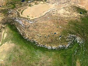
- Intermontane plateaus are the highest plateaus in the world. They are completely surrounded by mountains. The Tibetan Plateau in Asia is a famous example.
- Lava or volcanic plateaus form in areas where many volcanic eruptions have happened. Lava flows out from cracks in the Earth, spreads over a large area, and hardens into layers. Examples include the Antrim plateau in Northern Ireland, the Deccan Plateau in India, and the Columbia Plateau in the United States.
- Piedmont plateaus have mountains on one side and a plain or a sea on the other. The Piedmont Plateau in the eastern United States is an example, located between the Appalachian Mountains and the Atlantic Coastal Plain.
- Continental plateaus are surrounded by plains or oceans. They are usually far away from mountains. The Antarctic Plateau in East Antarctica is an example of a continental plateau.
Major Plateaus Around the World
Plateaus in Asia
The largest and highest plateau on Earth is the Tibetan Plateau. It is often called the "Roof of the World" because it is so high. This plateau is still growing as the Indo-Australian and Eurasian tectonic plates slowly crash into each other. The Tibetan Plateau covers about 2.5 million square kilometers (965,000 square miles) and is about 5,000 meters (16,400 feet) above sea level.
Other important plateaus in Asia include:
- Najd in the Arabian Peninsula (762 to 1,525 meters high)
- Armenian Highlands (about 400,000 square kilometers)
- Iranian plateau (about 3.7 million square kilometers)
- Anatolian Plateau
- Mongolian Plateau (about 2.6 million square kilometers)
- Deccan Plateau in India (about 1.9 million square kilometers)
Plateaus in Antarctica
Another huge plateau is the icy Antarctic Plateau. It is also known as the Polar Plateau. This is where the geographic South Pole is located. It covers most of East Antarctica. The ice on this plateau is about 3,000 meters (9,800 feet) thick. The weight of this massive ice cap is so great that some parts of the land beneath it are actually below sea level. If the ice were to melt, the land would slowly rise due to a process called isostasy.
Plateaus in North America
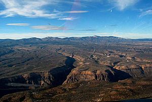
A large plateau in North America is the Colorado Plateau. It covers about 337,000 square kilometers (130,000 square miles) across Colorado, Utah, Arizona, and New Mexico.
In Arizona and Utah, the Colorado River cuts through the Colorado Plateau, forming the amazing Grand Canyon. Millions of years ago, the land in this area slowly began to rise. At the same time, the Colorado River was able to cut down into the Earth's crust at almost the same speed. This balance created the incredibly deep Grand Canyon we see today. The North Rim of the Grand Canyon is about 2,450 meters (8,040 feet) above sea level, and the South Rim is about 2,150 meters (7,050 feet) above sea level. At its deepest, the Colorado River is about 1,830 meters (6,000 feet) below the North Rim.
Another high plateau in North America is the Mexican Plateau. It covers about 601,882 square kilometers (232,388 square miles) and has an average height of 1,825 meters (5,988 feet). More than 70 million people live on this plateau.
Plateaus in South America
Tepuis are unique table-top mountains or mesas found in the Guiana Highlands of South America, especially in Venezuela. The word "tepui" means "house of the gods" in the language of the Pemon people.
Tepuis are like small, isolated plateaus. Because they are so cut off from other areas, they are home to many unique plants and animals found nowhere else. Some famous tepuis include Neblina, Autana, Auyan and Mount Roraima. They are made of strong sandstone and rise steeply from the jungle, creating stunning views. Auyantepui is where Angel Falls, the world's tallest waterfall, begins.
The capital city of Colombia, Bogota, is located on an Andean plateau called the Altiplano Cundiboyacense. This plateau is about the size of Switzerland and averages 2,600 meters (8,530 feet) above sea level.

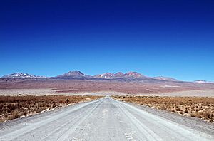
The Altiplano (meaning "high plain" in Spanish) is another very high plateau in South America. It is located in west-central South America, where the Andes mountains are at their widest. It is the largest high plateau on Earth outside of Tibet. Most of the Altiplano is in Bolivia and Peru, with some parts in Chile. Many cities are on the Altiplano, including Puno, Oruro, El Alto, and La Paz (the administrative capital of Bolivia). The northeastern part of the Altiplano is wetter, while the southwestern part is very dry and has many salt flats. Lake Titicaca, the largest lake in South America, is on the border between Bolivia and Peru.
Plateaus in Africa
The highest plateau in Africa is the Ethiopian Highlands. It covers the central part of Ethiopia. This is the largest continuous area of high land in Africa, with most of it above 1,500 meters (4,921 feet). Some peaks reach up to 4,550 meters (14,928 feet). It is sometimes called the "Roof of Africa" because of its height and size.
Another example is the Highveld in South Africa. This part of the inland plateau is mostly between 1,500 meters (4,921 feet) and 2,100 meters (6,890 feet) high. It is home to some of South Africa's largest cities.
In Egypt, you can find the Giza Plateau, famous for its ancient pyramids, and the Galala Mountain, which is about 3,300 meters (10,827 feet) above sea level.
Plateaus in Oceania
The Western Plateau is a very old landform covering much of southwestern Australia. It is about 700,000 square kilometers (270,000 square miles) in size and has an average height of 305 to 460 meters (1,000 to 1,500 feet).
The North Island Volcanic Plateau is a high area in the center of the North Island of New Zealand. It has volcanoes, lava plateaus, and crater lakes, including Lake Taupo, New Zealand's largest lake. This plateau stretches about 100 kilometers (62 miles) east to west and 130 kilometers (81 miles) north to south. Most of it is more than 600 meters (1,970 feet) above sea level.
See also
 In Spanish: Meseta para niños
 | James Van Der Zee |
 | Alma Thomas |
 | Ellis Wilson |
 | Margaret Taylor-Burroughs |

