Mexican Plateau facts for kids
Quick facts for kids
Mexican Plateau
Altiplanicie Mexicana
|
|
|---|---|
|
Region
|
|

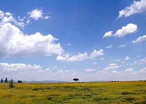
A view of the Mexican Plateau near San Miguel de Allende, Guanajuato
|
|

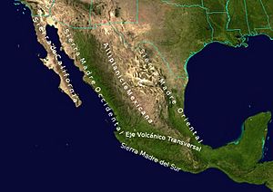
Geographic map of the highest Mountain Ranges of Mexico.
|
|
| Country | Mexico |
| Area | |
| • Total | 601,882 km2 (232,388 sq mi) |
| Population
(2000)
|
|
| • Total | 74,900,000 |
| • Density | 124.44/km2 (322.31/sq mi) |
The Mexican Plateau, also known as the Mexican Altiplano, is a huge flat area of land in northern and central Mexico. It's like a giant tableland that covers a big part of the country. This plateau is mostly dry or semi-dry.
It sits about 1,825 meters (5,988 feet) above sea level on average. The plateau stretches from the Mexico–United States border in the north all the way to the Trans-Mexican Volcanic Belt in the south. Tall mountain ranges border it: the Sierra Madre Occidental to the west and the Sierra Madre Oriental to the east.
A smaller mountain range in the state of Zacatecas divides the plateau into two main parts. These are called the Northern Plateau (Mesa del Norte) and the Central Plateau (Mesa Central). Even though they have different names, geographers usually see them as parts of one large plateau.
Most of the Mexican Plateau is covered by deserts and dry shrublands. However, the mountains around it have pine-oak forests. These forests also form "sky islands" on some of the smaller mountain ranges within the plateau. Many big cities in Mexico, like Mexico City and Guadalajara, are located on the southern part of this plateau.
Contents
Exploring the Geography of the Mexican Plateau
The Mexican Plateau is a vast region with distinct northern and southern sections. Understanding these parts helps us see how diverse this large landform is.
The Northern Plateau: Mesa del Norte
The Northern Plateau, or Mesa del Norte, is generally lower in elevation. It averages about 1,100 meters (3,600 feet) above sea level. This northern section extends south from the Rio Grande river. It covers parts of states like Chihuahua, Coahuila, Durango, Zacatecas, and San Luis Potosí.
This area has many narrow, isolated mountain ridges. You'll also find numerous dips or basins, with the Bolsón de Mapimí being the largest. Some rivers, like the Río Conchos and parts of the Río Bravo del Norte, flow through here. They eventually drain into the Gulf of Mexico. However, much of the Northern Plateau has internal drainage. This means its water doesn't flow out to the sea.
Plant Life in the Northern Plateau
The northern part of the Mesa del Norte is home to the Chihuahuan Desert. As you move south, you'll find different types of dry shrublands. These include the Meseta Central matorral and the Central Mexican matorral. These plants are adapted to the dry conditions of the plateau.
The Southern Plateau: Mesa Central
The Southern Plateau, or Mesa Central, is higher than its northern counterpart. It averages about 2,000 meters (6,560 feet) in elevation. This part of the plateau has many valleys. These valleys were originally formed by ancient lakes that existed long ago.
The Mesa Central stretches across states such as Aguascalientes, Jalisco, Zacatecas, Guanajuato, Querétaro, and Michoacán. Some of Mexico's most important cities, like Guadalajara, are located in the valleys of this southern plateau.
Rivers and Forests of the Southern Plateau
Much of the Southern Plateau is drained by the Río Grande de Santiago river and its branches, including the Río Lerma. These rivers flow west towards the Pacific Ocean. The eastern part of the southern plateau is drained by branches of the Pánuco River.
The main plant life here is the Central Mexican matorral, a type of dry shrubland. In the lower areas of the Lerma–Río Grande de Santiago basin, you'll find subtropical Bajío dry forests. Higher up, there are Madrean pine–oak woodlands. These include oak forests at lower elevations and mixed pine-oak and conifer forests closer to the treeline of the volcanoes that surround the plateau.
See also
 In Spanish: Mesa del Centro para niños
 | Percy Lavon Julian |
 | Katherine Johnson |
 | George Washington Carver |
 | Annie Easley |


