
Michoacán facts for kids
Quick facts for kids
State of Michoacán
|
|||
|---|---|---|---|
|
|||

Location within Mexico
|
|||

Municipalities of Michoacán
|
|||
| Country | |||
| Capital | Morelia | ||
| Municipalities | 113 | ||
| Area
Ranked 16th |
|||
| • Total | 59,928 km2 (23,138 sq mi) | ||
| Population
(2005)
|
|||
| • Total | 3,966,073 (Ranked 7th) | ||
| Time zone | UTC-6 (CST) | ||
| • Summer (DST) | UTC-5 (CDT) | ||
| HDI (2004) | 0.7422 - medium Ranked 29th |
||
| ISO 3166-2 | MX-MIC | ||
| Postal abbr. | Mich. | ||
| Website | Michoacán state government | ||


Michoacán is a beautiful state located in the southwest part of Mexico. It's home to about 4 million people. The capital city of Michoacán is called Morelia.
Geography of Michoacán

Michoacán is in the central-west part of Mexico. It shares borders with several other states. These include Mexico, Querétaro, Guerrero, Guanajuato, Jalisco, and Colima. The state also has a long coastline of about 217 kilometers (135 miles) on the Pacific Ocean.
Michoacán covers an area of about 58,837 square kilometers (22,717 square miles). This makes it the sixteenth largest state in Mexico. It also includes about 1,490 square kilometers (575 square miles) of ocean territory.
Mountains and Volcanoes
The state has three main land regions. These are the Sierra Madre del Sur, the Trans-Mexican Volcanic Belt, and the Inter-mountain Valleys. The Sierra Madre del Sur mountains run through the southwest of the state. They are about 200 kilometers (124 miles) long. The peaks in this range are usually around 2,900 meters (9,500 feet) high.
The Trans-Mexican Volcanic Belt crosses the state from west to east. This area is famous for its many volcanoes. Some are active, some are dormant (sleeping), and some are extinct (no longer active). The most famous volcano here is Parícutin.
Rivers and Lakes
Michoacán has many rivers and lakes. It includes parts of two of Mexico's largest rivers: the Lerma and the Balsas.
The northern part of the state has the Lerma River Basin. The Tepuxtepec Dam on the Lerma River holds a lot of water. Rivers like the Tlalpuhahua, Cachivi, and Duero flow into the Lerma in Michoacán. Lake Cuitzeo is another important water body in this region.

The central region has famous lakes like Pátzcuaro and Zirahuén. Lake Pátzcuaro is a large lake with several islands. These islands include Janitzio, Yunuén, and La Pacanda. Lake Zirahuén is also a beautiful lake. These two lakes are popular tourist spots.
Most of the state's rivers are in the southern region. The Balsas River is the most important here. Many smaller rivers flow directly into the Pacific Ocean along the coast.
Climate and Weather
The weather in Michoacán changes a lot depending on how high up you are. Average temperatures range from 13°C (55°F) to 29°C (84°F). Cooler temperatures are found in the northern and eastern highlands. The lower areas in the south and west are called La Costa (the coast) or Tierra Caliente (hot land). These areas are much hotter. Temperatures there often go above 30°C (86°F) and can even reach over 40°C (104°F) in summer.
Most of the state can get freezing temperatures in winter, except for the Tierra Caliente. Rainfall also depends on altitude. Mountain areas get more rain than the lowlands. The rainy season is from June to October across the whole state.
Flora: Plants and Trees
The types of plants in Michoacán depend on the altitude.
- High up, between 2,600 and 3,500 meters (8,500 and 11,500 feet), you'll find mostly pine forests.
- Between 1,000 and 2,600 meters (3,300 and 8,500 feet), there are mixed forests.
- Below 1,000 meters, you'll see broadleaf or tropical forests.
Some parts of the state, especially in the north and northeast, have grasslands.
Fauna: Animals of Michoacán

Michoacán is home to many different animals.
- Mammals include skunks, raccoons, cacomistles, rabbits, armadillos, mountain lions, and foxes.
- Birds are plentiful, with many water birds like ducks and storks. Seabirds can be found along the coast.
- Reptiles, amphibians, and fish live in the rivers, lakes, and coastal areas.
| Flora and fauna of Michoacán | |||||||
 |
 |
 |
 |
 |
|||
| Greater long-nosed bat | Ctenosaura pectinata | Monarch butterfly | Bobcat | Brachypelma auratum | |||
 |
 |
 |
 |
 |
|||
| Pheucticus chrysopeplus | Cambarellus patzcuarensis | Amazon kingfisher | White-nosed coati | Red warbler | |||
 |
 |
.jpg) |
 |
_001.jpg) |
|||
| Dioon tomasellii | Pinus devoniana | Dahlia coccinea | Abies religiosa | Sabal pumos | |||
Economy of Michoacán

Michoacán's economy relies on several key activities. These include farming, raising livestock, forestry, fishing, and making crafts. Most people in the state work in agriculture, manufacturing, or commerce.
Agriculture: Farming in Michoacán
Farming is a very important part of the state's economy. Over a million hectares (2.5 million acres) of land are used for agriculture. This is about 20% of Michoacán's total land. Most farming happens during the rainy season.
Important crops grown here include:
- Corn
- Sorghum
- Avocados (Michoacán is the world's largest producer!)
- Strawberries
- Peaches
- Wheat
- Limes
- Sugar cane
- Mangos
About 43% of the farmland is used for raising animals. Farmers raise cattle, chickens, sheep, goats, and pigs. In 2007, the value of meat, dairy, and eggs produced was over four billion pesos.
Forestry: Michoacán's Forests

Sixty percent of Michoacán is covered by forests. The most valuable forests are in the higher eastern parts of the state. These forests mainly produce wood and resin. Over half of these forests are pine trees.
One challenge for the forests is logging that isn't sustainable. This means trees are cut down faster than they can grow back. Besides logging, there are also special ecological reserves. These are important for tourism, especially the Monarch butterfly sanctuaries in the far east of the state.
Fishing: From Lakes to the Ocean
Michoacán's many lakes, rivers, and coastline make it a big producer of fish and seafood. Fish are caught in the wild and also raised on farms. The most important fish caught for sale are tilapia and carp.
Mining and Minerals
Mining is another important activity, especially in the eastern part of the state. Iron is mined near the coast in the Lázaro Cárdenas area. Michoacán mines both metals and non-metals.
Some of the minerals found here include:
Michoacán is the second-largest producer of coke and the third-largest producer of iron in Mexico. These are very important for making steel. Even though there are many valuable minerals, mining only makes up a small part of the state's economy.
Manufacturing: Making Goods
Most of Michoacán's factories are located near the capital city, Morelia. There are several industrial parks there. Other areas with factories include Apatzingán, Zamora, Jiquilpan, Sahuayo, and Lázaro Cárdenas.
The main things produced in these factories are:
- Iron and steel products
- Bottled drinks
- Paper products
Most people in Michoacán work in services and commerce (buying and selling goods). This sector contributes a lot to the state's overall economy. Many sales are for food, drinks, and tobacco.
Images for kids
-

Catholic priest and insurgent leader José María Morelos
-
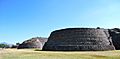
Yacata pyramids of Tzintzuntzan
-
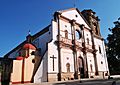
Basilica of Nuestra Señora de la Salud in Patzcuaro
-

La Calavera Catrina figure bought in Pátzcuaro
-
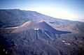
Parícutin in 1997
-
Monarch butterfly sanctuary near the pueblo of Angangueo
-
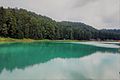
Laguna Larga in Los Azufres
-
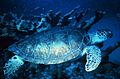
Green sea turtle swimming in the Mexican Pacific
-
Famed guitar town of Paracho
-
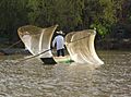
Fishermen in Lake Pátzcuaro
-
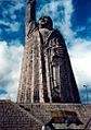
Statue of José María Morelos in Janitzio
-
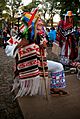
Danza de los Viejitos (Traditional folk dance of the Purépecha)
-

Noche de Muertos decorations
-
Jardin de las Rosas Garden and Park in Morelia
-
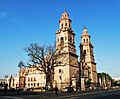
Cathedral of Morelia
-
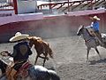
Traditional charro outfit
-
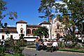
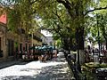
Gertrudis Bocanegra Plaza and the San Agustin Library in Zitacuaro
-
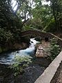
Cascada Parque Nacional in Uruapan


.jpg)


See also
 In Spanish: Michoacán para niños
