
Angangueo facts for kids
Quick facts for kids
Angangueo, Michoacán
|
|
|---|---|

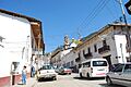
Main street of the town
|
|

Angangueo, Michoacán
Location in Michoacán

Angangueo, Michoacán
Location in Mexico
|
|
| Country | |
| State | Michoacán |
| Municipal Seat | Mineral de Angangueo |
| Town Founded | 1792 |
| Municipality Created | 1831 |
| Area | |
| • Municipality | 85.64 km2 (33.07 sq mi) |
| Elevation
(of seat)
|
2,560 m (8,400 ft) |
| Population
(2005) Municipality
|
|
| • Municipality | 9,990 |
| • Seat | 5,030 |
| Time zone | UTC-6 (Central (US Central)) |
| • Summer (DST) | UTC-5 (Central) |
| Postal code (of seat) |
51395
|
Angangueo (Spanish: [aŋɡaŋˈɡeo]) is a town and municipality in central Mexico. It's famous for its history of mining. It is also known for being part of the Monarch Butterfly Biosphere Reserve. The main town, called Mineral de Angangueo, is in a small canyon. This canyon is surrounded by tall, rugged, forested mountains.
The town was officially started in 1792. This happened soon after a large amount of valuable minerals was found there. The mines eventually closed in the 1900s. However, the area became popular for tourism. This was because it is very close to two special places where monarch butterflies live.
Contents
Exploring Angangueo Town

The town of Angangueo is officially called Mineral de Angangueo. This helps tell it apart from the wider municipality. Like many old mining towns, Angangueo has streets and blocks that are not in a perfect grid. This layout has stayed the same since the time of the Spanish colonies.
There is one main road that goes up the canyon. It is called both Nacional and Morelos. This road leads to the main square, known as Plaza de la Constitución. Most houses in town are made of adobe. They have wooden details and red tile roofs. Many also have balconies with colorful flowers in the summer. Some old mining towns, like Angangueo, even have secret tunnels. For example, a tunnel connects the Casa Parker to the Inmaculada Concepción church.
Churches and Historic Buildings
The main square has two churches next to it. These are the parish of San Simón and the Inmaculada Concepción. It's funny because their clocks often show different times!
The Inmaculada Concepción church was built by one family. It is made of pink stone in a Gothic style. It was designed to look like a smaller version of the Notre Dame Cathedral in Paris. The main altar inside is made of marble from Italy. It has statues of Saint Joseph and the Virgin Mary that came from Paris. The church also holds the "chalice of Angangueo." This is a very important example of Baroque silverwork.
The San Simón parish is smaller. It is built with blue-grey stone. Other small chapels in the town include Santa Maria Gorita, Misericordia, and Jesus Nazareno.
The Casa Parker used to be an old train station. In the mid-1900s, it became the home of Bill and Joyce Parker. They were an English and American couple. Bill was the last person in charge of the American Smelting and Refining Company mine before it became a national company. The Parkers became a big part of the community. Their house was later saved and turned into a historical museum. Another museum in the area is called El Molino.
You can also find the Monument to the Miner. It is on a lookout point above the town. The Señor del Rescate Chapel is also there. This chapel is now used for town offices.
Butterfly Tourism and Local Events
People in Angangueo still dig for some lead and silver in the hills. However, the town is now best known for being in the middle of the Monarch Butterfly Biosphere Reserve. There are two butterfly sanctuaries nearby that you can visit: Sierra Chincua and El Rosario.
Angangueo became known for its butterflies when magazines like National Geographic and México Desconocido wrote about it. They also wrote about the nearby town of Ocampo.
Every February, Angangueo hosts an annual monarch butterfly festival. This festival says goodbye to the butterflies as they fly north again. It includes art, cultural events, and celebrations of the region's traditions.
Another yearly event is the Day of the Miner on July 11. This day honors the mining way of life. Many people in town want to keep this tradition alive. Other yearly festivals in the municipality are religious. These include the feasts of Santa Cruz on May 3, San Simón on October 28, and the Immaculate Conception on December 8.
There is also a bus service that connects Angangueo to Zitácuaro.
Angangueo Municipality

The town of Angangueo is the main government center for about thirty other communities. Together, these communities make up the municipality, which covers 85.64 square kilometers. About half of the municipality's population of 9,990 (in 2005) lives in the main town. Other important communities include Colonia Independencia, Jesús Nazareno, Catingón, and La Estación.
The municipality is in the far northeast part of the state of Michoacán. It is part of the Tlalpujahua region. It shares borders with the municipalities of Senguio, Ocampo, and Aporo. The State of Mexico is to its east. Most of the municipality is rural. There are over 2,000 homes and some public sports facilities in the main town and other communities. Roads connect Angangueo directly to the nearby municipalities of Aporo and Tlalpujahua.
Education in the Municipality
The municipality has schools for different age groups. These include preschool, primary school, middle school, and vocational schools. Many of the middle and vocational schools offer distance education.
Public schools in the area include:
- 11 de Julio preschool
- 25 de Abril preschool
- Benito Juarez preschool
- Carmen Serdan preschool
- Cbtis 18 vocational high school
- Educacion y Patria primary school
- Patito Feo preschool
- Emiliano Zapata primary school
- Escuela Primaria primary school
- Escuela Telesecundaria Estv 16 314 middle school
- Escuela Telesecundaria Estv 16 735 middle school
- Escuela Secundaria Tecnica 2 middle school
There is also one private primary school called Corregidora.
Local Economy
Tourism related to the monarch butterflies makes up over a quarter of the municipality's economy. However, most of this tourism happens in the main town. The town earns most of its money from tourism and shops.
Most of the other land in the municipality is used for forestry. This includes both legal and illegal logging. Much of the illegal logging happens in the butterfly reserve areas. Organized groups often do this logging. They have even fought against efforts by state and federal police to stop them.
Another quarter of the economy comes from farming. The main crops are corn and wheat. Other crops include barley, beans, and fava beans. Apples, peaches, pulque maguey, pears, and capulin are also grown. Raising animals like cattle, pigs, sheep, and chickens makes up about five percent of the economy. This is a major source of income for many communities.
There is still some very small amount of mining for copper, zinc, lead, iron, silver, and gold. Some food processing and metal product manufacturing also happen.
In 2005, a census showed that sixteen people in the municipality spoke an indigenous language. Most of them spoke Mazahua and Mixe. The main religion in Angangueo is Catholicism.
Angangueo's History
People don't fully agree on what the name Angangueo means. It has been translated as "entrance to the cave," "very high thing," and "inside the forest." The municipality has its own coat of arms, which is divided into three parts. One part has symbols for mining. The second part shows a monarch butterfly. The third part has mountains and the sun, representing the area's landscape.
When Nuño de Guzmán arrived in the area in 1550, he described it as an empty land. He didn't know about the rich minerals hidden beneath the mountains and forests. The land was later given to Gonzalo de Salazar by Viceroy Antonio de Mendoza. This was part of a larger area that included Zitácuaro and Taximaroa.
Some mining and settlement began in the mid-1500s. But the area stayed mostly empty until the late 1700s. That's when large amounts of minerals were found on what was once the hacienda of Angangueo. These minerals included gold, silver, copper, and more. This discovery brought many people to the area very quickly. The town of Angangueo was officially founded in 1792. It became a municipality in 1831.
During the Reform War in Mexico in the 1800s, control of the town changed hands. In 1865, General Régules took the town square for the Conservative forces. But Liberal forces took the town back the next year. The building of the Temple of the Inmaculata Concepción began in 1882.
In the mid-1800s, an English company called Negociación Minera de las Trojes got the rights to mine here. In the 1900s, these rights went to a U.S. company, American Smelting and Refining Company. This was the last foreign company to own mining rights.
In 1953, a terrible accident in the Dolores Mine killed twenty-five miners. After this, the Mexican government took control of the mining area. It was then managed by Impulsora Minera de Angangueo. This company continued mining until 1991. At that time, it was decided that mining was no longer profitable. Since then, there have been disagreements between the company's owners, former miners, and the state of Michoacán. These disputes are about the right to continue mining. The mines are now considered part of the butterfly reserve.
In the mid-1900s, the town had about 10,000 people. It even had its own newspaper and a place to make coins. However, the town's size has slowly shrunk since the mines closed.
Angangueo found a new way to earn money through tourism. This happened when the Monarch Butterfly Biosphere Reserve was created. Magazines like National Geographic and Mexico Desconocido started promoting the butterfly colonies near the town in 1980. This led to hotels and restaurants opening near the butterfly sites. Small transportation services also started up. However, this tourism has not made the town as big as it once was.
Angangueo's Geography
Angangueo is in a very mountainous area. The average height above sea level is about 2,580 meters. Its landscape is part of the Trans-Mexican Volcanic Belt and the Sierra de Angangueo mountains. Two rivers, the Puerco and the Carrillos, flow through the area. Several smaller streams also run through the land.
Angangueo has a spring-like climate, meaning it's usually mild. Some areas get rain only in the summer, while others get rain all year round. Most of the area is covered in forests. These forests have conifer trees like pines, oyamel, and juniper. There are also mixed forests with conifers like cedar and broad-leafed trees.
Wildlife in the area includes weasels, rabbits, squirrels, skunks, deer, and various birds. A large part of the municipality is within the Monarch Butterfly Biosphere Reserve. This includes Cerro de las Papas, which is home to a major colony of monarch butterflies each winter.
Environmental Challenges
On February 5, 2010, heavy rains and hail caused floods and mudslides in the region. Angangueo was hit very hard. Landslides on two hills around the town buried parts of it and blocked roads. A week before, a smaller slide had killed three miners. The landslides in 2010 forced hundreds of people to leave their homes. This was because there was a danger of more slides. The Topos de Tlatelolco (a rescue team) helped search for survivors and bodies.
At least 1,000 people lost their homes. They moved to a shelter in San José del Rincón, Mexico State. Many houses built near the river were washed away. At least thirty people died in the town alone. Bodies were found in the main town and in smaller communities like Salitre. A total of 2,500 people lost everything they owned in this disaster.
President Calderón visited the disaster area. He looked at the damage both on the ground and from the air. Michoacán's governor, Leonel Godoy, joined him to see the damage. President Calderón suggested that Angangueo could focus on tourism as a Pueblo Mágico (Magic Town). This would be an alternative to mining. However, local residents wanted to be sure that their town would not disappear. They also wanted to know that jobs would still be available.
According to Alejandro Méndez, the director of the Forest Commission of Michoacán, deforestation made the 2010 landslides worse. This deforestation was caused by both legal and illegal logging. Also, homes were built on cleared areas on hillsides. The landslides in Angangueo and other places like Zamora led government officials to study what caused these events. They also looked at how they responded to the emergencies.
Later in February, federal officials announced that no new residents could move into the town. They also said that the people living there would be moved to a new location. This decision was made because the landslides made the current location too dangerous. A "New Angangueo" was planned to be built. However, local residents were against this plan.
Efforts to move the town officially began in June 2010. The plan was to build 600 homes in a place called Barrio Sustentable Monarca. But construction stopped by September of that same year. Only a layout was drawn on the site, and no new homes were started.
As tourism grows, the Monarch Butterfly Biosphere Reserve faces higher risks. Thousands of tourists walk the trails around the butterfly habitats each year. While local people want other ways to earn money, the government is trying to increase tourism. However, not enough has been done to control the growth of buildings, entertainment, noise, and vehicles in the biosphere area. These things are increasing and could disturb the butterflies.
See also
 In Spanish: Mineral de Angangueo para niños
Images for kids
-
Main street of the town
