Lerma River facts for kids
Quick facts for kids Lerma River |
|
|---|---|

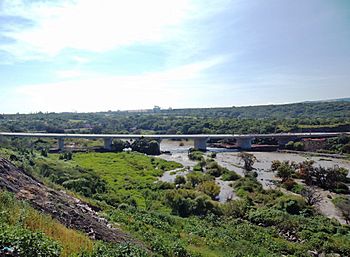
Bridge over the Lerma River
|
|

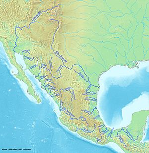
Major rivers of Mexico, with Lerma in the center
|
|
| Country | Mexico |
| Physical characteristics | |
| Main source | lagoons near Almoloya del Río, Mexican Plateau 19°09′43″N 99°30′05″W / 19.162041666667°N 99.501452777778°W |
| River mouth | Lake Chapala (→Río Grande de Santiago→Pacific Ocean) |
| Length | 750 km (466 mi), without Río Grande de Santiago |
The Lerma River (Spanish: Río Lerma) is Mexico's second longest river. It is about 750 km-long (470 mi) and flows through west-central Mexico. The river starts high up on the Mexican Plateau, more than 3,000 metres (9,843 ft) above sea level. It ends by flowing into Lake Chapala, which is Mexico's largest lake, near Guadalajara, Jalisco.
Some people think the Río Grande de Santiago is a continuation of the Lerma River. This is because the Río Grande de Santiago starts from Lake Chapala. Together, these two rivers are often called the Lerma Santiago River (Spanish: Río Lerma Santiago). The Lerma River used to have a lot of pollution. However, its water quality has gotten much better recently. This is thanks to government programs and big projects to improve how wastewater is treated.
Contents
Where Does the Lerma River Flow?
The Lerma River begins in the Lerma lagoons. These lagoons are near Almoloya del Río, on a high plateau. This area is more than 2,600 metres (8,500 ft) above sea level and about 24 kilometres (15 mi) southeast of Toluca. The lagoons get their water from springs that come from volcanic rocks. These springs are located between the Valley of Toluca and the Basin of Mexico.
The river forms a short border between the states of Querétaro and Michoacán. Then it flows west-northwest through the state of Guanajuato. After that, the river turns south. It then separates Guanajuato and Michoacán, and later Michoacán and Jalisco. Finally, after flowing for about 560 kilometres (350 mi), it empties into Lake Chapala. This is about 24 kilometres (15 mi) west-southwest of La Barca.
The entire Lerma River is 750 kilometres (470 mi) long. When it flows into Lake Chapala, the water level is about 1,510 metres (4,950 ft) above sea level. Some people consider the 400-kilometre (249 mi) long Río Grande de Santiago to be a part of the Lerma River system. The Río Grande de Santiago continues from Lake Chapala northwest towards the Pacific Ocean.
Why the Lerma River is Important to Mexico
The Lerma River and Lake Chapala area is very important to Mexico. The government considers it the most important watershed in the country. A watershed is an area of land where all the water drains into a single river or lake.
With its main branches like the Laja, Apaseo, and Turbio, the Lerma River forms Mexico's largest river system. The Lerma River is not deep enough for boats to travel on. However, it is extremely important for watering farms in the region. About 67% of the farmers in the Lerma River/Lake Chapala area are small farmers. Currently, over 820,000 hectares (about 2 million acres) of land are watered by the river. An estimated three million hectares (about 7.4 million acres) are used for farming.
In 1997, about 9.35 million people lived in the Lerma River watershed. The population is spread out among many towns and villages. About 18 of these places have more than 50,000 people. Around 32% of the people live in rural areas. The Lerma's water is also used for drinking water in big cities like Guadalajara and Toluca. While large cities have enough water, rural areas often struggle to get clean drinking water from the river and the underground water sources (aquifers) that feed it.
Animals and Plants of the Lerma River
The Lerma–Chapala–Grande de Santiago river system is full of different kinds of freshwater fish. It is home to more than 100 types of fish that are native to the area. There are also 19 types of fish that have been brought in from other places.
Among the native fish, two families are the most common:
- Splitfins: These make up about a quarter of the native fish species.
- Neotropical silversides: These also make up about a quarter of the native fish species.
- Other important fish families include poeciliids and cyprinids.
Many of these fish are found nowhere else in the world. This means they are endemic to this river system. Some examples include:
- Several Chirostoma silversides (also called "charales")
- Several types of splitfins
- A few Poeciliopsis livebearers
- Some Algansea chubs
- Two Yuriria chubs
- A few Notropis shiners
- Two Ictalurus catfish
- Two Tetrapleurodon lampreys
Many of these unique species are now threatened, meaning they are at risk of disappearing. Sadly, a few Chirostoma silversides and all three Evarra chubs are already extinct.
The Lerma–Chapala–Grande de Santiago river system also has four types of crayfish that are found only there. These are Cambarellus chapalanus, C. lermensis, C. prolixus, and Procambarus digueti.
Efforts to Reduce Pollution
The Lerma River has had ongoing problems with pollution. Most of this pollution came from wastewater that was not treated properly before being released into the river. Reservoirs, which are like big storage lakes built to control the river's flow, often became filled with water hyacinths. This plant grows a lot because of too many nutrients from the untreated wastewater. Industries in the Lerma River area, such as those making meat, dairy, paper, and chemicals, often did not treat their wastewater.
The pollution became very bad in the late 1980s. This was because water policies were not well organized. They did not control how different groups used water or consider how pollution upstream affected people downstream. Because of strong public pressure, the government created plans to clean up the river. This led to better water quality in the 1990s.
By 1997, 45 water treatment plants were working regularly. They were able to treat about 70% of the wastewater. Six more plants were being built to treat even more water. In Lake Chapala, where the Lerma River flows, water quality improved a lot. In 1989, 90% of the lake had poor water quality. By 1997, 85% of the lake had good water quality! However, the water quality was still worst closest to where the Lerma River entered the lake.
Even with improvements, there were still concerns about pollution in the 2000s. Studies in Michoacán and Guanajuato showed increases in certain illnesses in people living near the river. The part of the Lerma River closest to its source near Almoloya del Río is still considered the most polluted. Since 2005, industrial chemicals have become a serious concern. Also, plants in and around the river continue to be lost. In 2005, thousands of fish suddenly died in the river in Guanajuato state. This happened because pollution used up all the oxygen in that part of the river. The lower parts of the river, closer to Lake Chapala, are generally in better condition because there are fewer cities there.
See also
 In Spanish: Río Lerma para niños
- List of longest rivers of Mexico
 | Victor J. Glover |
 | Yvonne Cagle |
 | Jeanette Epps |
 | Bernard A. Harris Jr. |

