
Querétaro facts for kids
Quick facts for kids
State of Querétaro
|
|||
|---|---|---|---|
|
|||

Location within Mexico
|
|||
| Country | |||
| Capital | Santiago de Querétaro | ||
| Municipalities | 18 | ||
| Area
Ranked 27th |
|||
| • Total | 11,449 km2 (4,420 sq mi) | ||
| Population
(2005)
|
|||
| • Total | 1,598,139 (Ranked 23rd) | ||
| • Density | 139.59/km2 (361.5/sq mi) | ||
| Time zone | UTC-6 (CST) | ||
| • Summer (DST) | UTC-5 (CDT) | ||
| HDI (2004) | 0.8015 - high Ranked 12th |
||
| ISO 3166-2 | MX-QUE | ||
| Postal abbr. | Qro. | ||


Querétaro is a state in Mexico. Its full name is "Estado Libre y Soberano de Querétaro de Arteaga," which means "Free and Sovereign State of Querétaro de Arteaga." The capital city is Santiago de Querétaro.
The name Querétaro comes from ancient times. The Tarascans, an indigenous group, called a place now known as La Cañada "Crettaro" or "Queréndaro." This means "place of the crags," likely because of the pink stone found there. Other groups had their own names for the area. The Otomí called it "Mxei," meaning "the place where the ballgame is played." The Aztecs called it "Tlaxco," with the same meaning. The Chichimecs named it "Xico," also meaning "great ballcourt." This name came about because the La Cañada area looks like a huge ancient ballcourt.
Contents
Discover Querétaro: Culture and Traditions

Querétaro has a rich culture with a long history of art, music, and traditions.
Art and Artists
During the time when Spain ruled Mexico, artists in Querétaro mainly created religious paintings. Later, in the 1800s, artists like José Mariano Perrusquia y Rubio started making different kinds of art, including photography. Many talented artists have come from Querétaro, and their works can still be seen today. Natalia Baquedano was one of Mexico's first women to open a photography studio. She started her training in Querétaro.
Famous Writers
The state has also produced many writers. In the 1800s, there were poets, journalists, and playwrights like Juan María Wenceslao Sánchez de la Barquera y Morales. In the 1900s, important writers included Francisco Cervantes, a poet and translator known internationally. Today, new poets like Román Luján continue this tradition.
Music and Dance
Indigenous music is still played in Otomi areas, often with flutes or violins and drums. A special type of Otomi music called viñuetes uses two drums and a violin.
Huapango is a very popular music style in the Sierra Gorda region. There are two main types: Huasteco and Arribeño. Huasteco is played by three musicians using two guitars and a violin. The singers often use a high-pitched voice and make up verses as they go. Arribeño is common in the mountains near San Luis Potosí and Guanajuato. It uses two violins and two guitars. The songs are often poetic and can be religious.
Every April, the town of San Joaquín hosts the National Huasteca Huapango Contest. This big event brings thousands of people together to celebrate this lively dance and music.
Festivals and Celebrations
Most traditional festivals in Querétaro are linked to the Catholic religion. Important ones include Candlemas, Holy Week, and Day of the Dead. Towns also have festivals for their patron saints.
There are also many civic and economic festivals. These include celebrations for the founding of cities and regional fairs. Fairs in places like Cadereyta and Jalpan de Serra show off local products and culture.
México Folklórico is a dance group started in 1990. It's made up of high school students who are children of teachers. They perform dances from all over Mexico and have even traveled to other countries.
Delicious Local Foods
The food in the Sierra Gorda region is similar to that of nearby Hidalgo and San Luis Potosí. A special dish is sacahuil, a large tamale wrapped in papatla leaves. It's popular in Landa de Matamoros and Jalpan de Serra.
In San Miguel Tolimán, a main dish for festivals is chickpeas with saffron and colorful tortillas. In Peñamiller, people enjoy goat meat with pulque, a traditional drink. Another common dish is arriero tostadas.
Traditional drinks include simichol, a fermented corn drink from Santiago Mexquititlán, and charape, made with piloncillo (a type of brown sugar) in San Joaquín. In central areas, gorditas de migajas (crumb gorditas) are a common snack.
Sweet Treats and Unique Ingredients
Querétaro is known for its sweets. These include guava candy, jams, and sweets made from pulque. Bernal is famous for its milk candies. The Otomis make a hard bread called mezquitamal. Various types of mole sauces are made in Amealco.
In the Sierra Gorda, gorditas can be sweet, made with sugar, cheese, and piloncillo. The zacahuil tamale is filled with chicken, turkey, or pork and chili peppers. Some traditional dishes even use insects like tantárreas (ants) and escamoles (ant larvae), often cooked with cactus flowers. A native drink called mejengue is made with piloncillo, banana, pulque, and corn.
Querétaro's Past: A Journey Through History
The capital city's full name is Santiago de Querétaro. Both the state and city are usually just called Querétaro. The name likely comes from the Purépecha word "Créttaro," meaning "place with crags."
Early Settlements and Indigenous Groups
People lived in Querétaro as early as 500 BCE, during the time of the Teotihuacán civilization. The area was home to many different groups, including the Otomi, Toltecs, Chichimecas, Purépechas, and Mexicas. By the 12th century, most people who remained were hunter-gatherers or lived in small farming villages.
Powerful empires like the Aztec Empire and Purépecha Empire influenced parts of Querétaro in the 1400s. However, they never fully controlled the area. New groups, like the Pames and Chichimeca Jonaz, also moved into the state.
Spanish Arrival and Conquest
When the Spanish arrived in the early 1500s, the Otomi were the largest indigenous group. Many Otomi fled to Querétaro to escape the Spanish. The Spanish began to settle the area between 1529 and 1531.
A major battle happened in 1531 at a sacred hill called Ynlotepeque (now Sangremal). The Spanish, with their indigenous allies, fought the local Otomi and Chichimecas. Stories say that during the battle, a total solar eclipse occurred. This scared the natives, and the Spanish claimed to see an image of Saint James, the patron saint of Spain. This led to the natives surrendering. This is why the city is named Santiago (Saint James) de Querétaro. A stone cross was built on the hill to remember this event.

For a long time, the Spanish shared power with local indigenous leaders. However, Spanish power grew, and they eventually controlled the entire area. The last resistant groups, the Chichimec Jonaz, were not fully brought under Spanish rule until the late 1700s. The city of Querétaro became a key starting point for Spanish expeditions and missions heading north.
The Sierra Gorda Missions

The northern part of the state is called the Sierra Gorda, a rugged area with diverse climates. For centuries, the Spanish struggled to control this region due to strong resistance from native peoples. Unlike the groups in the south, the Pames and Chichimeca Jonaz were mostly hunter-gatherers, not used to strict rules.
In the mid-1700s, the Spanish government decided to take control of the Sierra Gorda because it was on important routes to mining areas. After a decisive battle in 1748, the area was pacified. This allowed for the establishment of five important missions in the heart of the Sierra Gorda. These missions, built by Junípero Serra, are now a World Heritage Site.
Growth and Importance in Colonial Times
Querétaro grew stronger during the 1600s. In 1655, Santiago de Querétaro was declared a city. The city's coat of arms became the state's coat of arms. Querétaro became very important because it connected the newly explored northern lands to the center of New Spain (Mexico City). Many trade routes met here, making it a cultural hub.
.jpg)
Franciscan missionaries played a big role in building the state's economy, society, and religious institutions. They were also responsible for many of the beautiful religious buildings and artworks still seen today. The most important structure from this time is the Aqueduct, which brought water to the city.
By the 1700s, Querétaro was very wealthy due to its location and livestock production. It was also the first major producer of wool cloth in New Spain. A large tobacco factory was built, and there was some silver mining.
Role in Mexican Independence
The city of Querétaro was crucial just before the Mexican War of Independence. It was where a secret group, including Miguel Hidalgo, Ignacio Allende, and Josefa Ortiz de Domínguez, planned the revolt against Spanish rule. When their plan was discovered, Ortiz de Domínguez warned Miguel Hidalgo, who then decided to start the war earlier, on September 15, 1810.
After the war, Querétaro became a state in 1824. However, it lost some of its economic importance. The 1800s were a time of political instability, with many changes in governors.
Key Events in the 19th Century

Querétaro's capital city saw many important events in the 1800s. During the Mexican–American War, Mexico's capital was moved to Querétaro. The Treaty of Guadalupe Hidalgo, which ended that war, was signed here.
The 1857 Constitution of Mexico was also published in the city. Later, during the short rule of Emperor Maximilian I, battles between different political groups took place in Querétaro. Maximilian was eventually captured and executed near the city in 1867.
Despite the political unrest, Querétaro saw economic growth. Textile mills were established, and mining continued. Modern services like electricity, telegraphs, and telephones began to appear. The capital city was connected to the rest of the country by rail in 1882. Public education also started in the early 1900s.
The Mexican Revolution and Modern Era
Strikes and protests against the government began in Querétaro before the Mexican Revolution. In 1916 and 1917, the federal government moved Mexico's capital to Querétaro. The country's current 1917 Constitution was written and announced in the city's Teatro de la República.
After the Revolution, Querétaro's economy slowly recovered. From 1940 to 1960, industrial growth sped up, and the population increased. Today, many industrial parks are located north of the capital. The city has grown a lot, but its historic center was preserved and declared a World Heritage Site in 1996.
In 1997, the National Action Party (PAN) won the governor's election, marking a change in leadership. In 2008, the state's constitution officially made "Querétaro" the state name. A new aqueduct, Acueducto II, was opened in 2011 to bring water to the city from distant springs, helping meet the city's growing needs.

Querétaro's Economy
Querétaro's economy is strong and follows national trends. Agriculture's role has decreased, while manufacturing, trade, and services have grown. The city of Querétaro is the state's most important economic center, followed by San Juan del Río.
Querétaro's location is a big advantage. It's connected by highway to Mexico City, the country's largest market. This makes it a key stop for people and goods traveling north and south. This has helped industries grow, especially since the 1970s. The state also has a stable social and political environment with low crime rates. It's known for having low levels of corruption among Mexican states.
The state's municipalities are grouped into five economic regions: Amealco, Cadereyta de Montes, Jalpan de Serra, Querétaro, and San Juan del Río. Each region has its own main economic activities.
Farming and Forests

Farming and raising livestock have always been important in Querétaro. While they make up a small part of the state's overall economy, they provide many jobs in rural areas. About 28% of the state's land is used for farming, mostly for corn, wheat, alfalfa, sorghum, and squash.
Much of the large-scale farming uses irrigation. Grains and vegetables like broccoli and carrots are grown on irrigated land. Most non-irrigated land is used for corn and beans, mainly for local use. Leading crops sold for profit include beans, cabbage, onions, and sorghum.
Querétaro is a top producer of milk and chicken in Mexico. Livestock farming, including cattle, pigs, sheep, and goats, is growing. The largest livestock producers are Jalpan, Cadereyta, San Juan del Río, and Querétaro.
Forests are one of the state's main natural resources. They contain valuable trees like pine, oak, cedar, and mesquite, mostly in the Sierra Gorda area.
Mining and Manufacturing

Mining, manufacturing, and construction make up about 39% of the state's economy. Mining is a traditional activity. The Sierra Gorda region has ten mining areas that produce lead, silver, zinc, copper, gold, mercury, and antimony. Non-metal products include marble and kaolin. Opals are a special resource found in the state.
The state government encourages foreign companies to invest in Querétaro, especially in industries that use less water. These include auto parts, food processing, and electronics. Other major industries are chemicals, plastics, textiles, and paper products. Most of these are small and medium-sized businesses.
Many manufacturing companies are located in or around the city of Querétaro. Well-known food companies like Carnation and Purina have facilities here. Tremac, an auto parts maker, is one of the biggest employers. Querétaro has many companies with foreign investment and many that export products. Modern industrial parks, like El Marques Industrial Park, host international businesses.
Querétaro has become a leading center for the aeronautics industry in Mexico. Bombardier, a Canadian company, opened a plant here in 2005. This plant makes parts for airplanes, including wings for the Learjet 85. It's the largest aeronautics facility in Mexico, employing about 2,000 people.
The state is also known for its dairy products and wine. Two cities, San Juan del Río and Ezequiel Montes, have growing wine industries. Some of the best wines come from vineyards like Freixenet, which has a special cave 25 meters underground to store wine. Cheese producers make products from goat, cow, and sheep milk.
Traditional Handcrafts

Querétaro is famous for its handcrafts, including baskets, textiles, metal items, pottery, and things made from wood, leather, and paper.
Basket making is common across the state. People use materials like reed, willow, and palm fronds to create baskets, hats, and decorative items. In Jalpan de Serra, they make bags, hats, and mats from palm fronds. Fine woven hats and willow baskets are found in Tequisquiapan.
Tolimán is known for its traditional clothing, especially quexquemetls made of silk for men and cotton for women. These are the largest in Mexico and are made on special looms. They also weave and embroider bags and linens. In Amealco de Bonfil, Otomi blouses and skirts are embroidered with traditional designs. They also make cloth dolls in traditional clothing.
Working with sandstone is a big business because there's a lot of it in the mountains. People create sculptures and building blocks from this stone. Communities in Pedro Escobedo and Huimilpan are known for their stonework, which is even exported. Marble is also worked, especially in Vizarrón and Tequisquiapan. Opals, which are mined in the state, are often made into jewelry.
Many communities specialize in pottery, making everything from everyday dishes to figures and sculptures. The clay from Cadereyta is known for its quality.
Other crafts include wooden furniture, toys, and musical instruments, especially guitars and violins made in San Joaquín. Leather is used for belts, handbags, and cowboy boots. Cardboard is used to make masks and large figures for parades and festivals, especially in the city of Querétaro.
Commerce, Services, and Tourism

Trade, services, and tourism make up 57% of Querétaro's economy. Since the 1990s, the state has promoted tourism by building hotels and other facilities. The Querétaro Convention Center, opened in 2011, helps attract business travelers.
The historic centers of Querétaro city and San Juan del Río are protected as historic monuments. Querétaro's historic center is a World Heritage Site recognized by UNESCO. Most historic and cultural attractions are in the capital city. Museums include the Museo de Arte de Querétaro and the Museo Regional de Querétaro. Outside the capital, you can find the Museo de la Muerte in San Juan del Río. The 74-arched aqueduct, built in the early 1700s, is another major attraction.
Querétaro offers many opportunities for ecotourism, especially in the Sierra Gorda region. This area is a complex of canyons and mountains with amazing biological diversity. It's a biological reserve with many plant and animal species, including some that are endangered like macaws and the black bear.
The state promotes its wine and cheeses with a "Ruta del Vino" or Wine Route. This route connects three major wineries (Freixenet, La Redonda, Los Aztecas) with cheese producers and charming towns like Tequisquiapan and Bernal. There's also a Cheese and Wine Museum. Visitors can learn how wine and cheese are made. Tequisquiapan hosts the National Cheese and Wine Fair in late May and early June.

Querétaro has one Pueblo Mágico (Magic Town), San Sebastián Bernal. It's famous for the Peña de Bernal, the third largest monolith in the world. This giant rock was considered sacred by the Chichimeca people. The town of Bernal has many old colonial buildings made of sandstone. Today, tourism is a big part of Bernal's economy, attracting people interested in history and outdoor activities.

Many old haciendas (large estates) in Querétaro have been turned into hotels and spas. These places keep their original colonial architecture while offering modern comforts. Examples include the Juriquilla Hacienda and the Jurica Hacienda.
The state also has several colonial-era missions, mostly in the Sierra Gorda region. These missions were built by missionaries like Junipero Serra in the 1700s to spread Christianity. Famous missions include Santiago de Jalpan, San Miguel Concá, and Nuestra Señora de la Luz de Tancoyol. After being restored, there are efforts to make these missions a World Heritage Site.
Images for kids
-
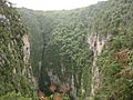
Sótano del Barro in the Sierra Gorda
-
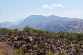
A semi-desert area in the municipality of Peñamiller
-
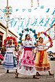
Baile de las inditas in El Pueblito, Corregidora Municipality. These dances are performed during the fiesta patronal of the Virgen of El Pueblito.
-
The logo of the Universidad Tecnológico de San Juan del Río.
-
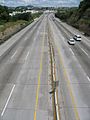
Highway 57 in Querétaro.
-
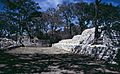
The ruins at Las Ranas.
-
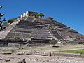
The pyramid at El Cerrito.


See also
 In Spanish: Querétaro para niños
