Lázaro Cárdenas, Michoacán facts for kids
Quick facts for kids
Lázaro Cárdenas
|
||
|---|---|---|
|
City
|
||

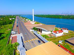
Lázaro Cardenas Boardwalk
|
||
|
||
| Nickname(s):
Lazaro Cardenas el Puerto de Todos
|
||
| Motto(s):
Lazaro Cardenas el Puerto sin Limites
|
||
| Country | Mexico | |
| State | Michoacán | |
| Municipality | Lázaro Cárdenas | |
| Founded | 1931 | |
| Elevation | 10 m (30 ft) | |
| Population
(2010)
|
||
| • Total | 178,817 | |
| Time zone | UTC-6 (CST) | |
| • Summer (DST) | UTC-5 (CDT) | |
| Area code(s) | 753 | |
Lázaro Cárdenas is a busy port city in the Mexican state of Michoacán. It is located where the Río Balsas river meets the Pacific Ocean. The city is named after Lázaro Cárdenas del Río, who was a president of Mexico from 1934 to 1940. He was born in Michoacán.
In 2005, about 74,884 people lived in the city. The larger area, called the municipality of Lázaro Cárdenas, had a population of 162,997 people. This area includes nearby communities like Las Guacamayas, La Orilla, and La Mira y Guacamayas.
Contents
History of Lázaro Cárdenas
The city we know today as Lázaro Cárdenas has had a few different names!
Early Days as Los Llanitos
Originally, this area was known as Los Llanitos. It was part of a larger region called Arteaga.
Becoming Melchor Ocampo
In 1932, Los Llanitos was officially recognized as a town. It was then given a new name: Melchor Ocampo. This name honored Melchor Ocampo, an important Mexican politician.
Renamed for a President
On April 12, 1937, the area became its own municipality, still called Melchor Ocampo del Balsas. However, the name changed again on November 17, 1970. It was renamed Lázaro Cárdenas. This was done to remember the popular former president, Lázaro Cárdenas del Río, who had passed away the month before.
Getting There: Air Travel
Lázaro Cárdenas has its own airport, called Lázaro Cárdenas Airport. This airport helps people travel to and from the city by air.
The Important Port of Lázaro Cárdenas
Lázaro Cárdenas is famous for its large, deepwater seaport. This port is a very important place for trade and shipping in Mexico.
What the Port Handles
The port handles many different types of goods. It manages large containers filled with products, as well as dry goods like grains, and liquid cargo. It also helps export cars made in Mexico to countries in Asia and South America.
Port Capacity and Growth
In 2012, the port handled about 1.24 million TEU (a way to measure shipping containers). The port is growing and aims to handle 2.2 million TEU each year!
Connecting to Other Places
Goods move to and from the port by both road and train. The train service is provided by Kansas City Southern de México. This port is becoming very important because other ports, like those in Los Angeles and Long Beach in the U.S., can get very crowded. Lázaro Cárdenas is also closer to big cities like Chicago, Kansas City, and Houston.
To prepare for more goods, the roads and railways that go north and south through Mexico have been improved. This helps move products faster to the United States.
See also
- In Spanish: Lázaro Cárdenas (Michoacán) for kids
 | Lonnie Johnson |
 | Granville Woods |
 | Lewis Howard Latimer |
 | James West |


