Balsas River facts for kids
Quick facts for kids Balsas River |
|
|---|---|

Balsas River
|
|

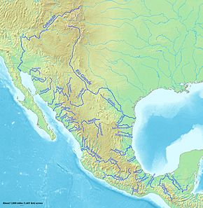
Major rivers of Mexico, with Balsas in the southwest
|
|
| Other name(s) | Mezcala River, Atoyac River |
| Country | Mexico |
| State | Michoacán |
| Physical characteristics | |
| River mouth | Mangrove Point, Pacific Ocean |
| Length | 771 kilometers (479 mi) |
| Basin features | |
| River system | Confluence of the San Martín River and Zahuapan River |
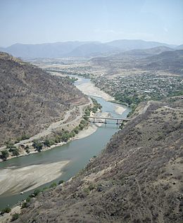
The Balsas River (Spanish: Río Balsas), also known as the Mezcala River or Atoyac River, is a major river in south-central Mexico.
This important river flows through the states of Guerrero, México, Morelos, and Puebla. After passing Ciudad Altamirano, Guerrero, it forms the border between Guerrero and Michoacán. The Balsas River carves its way through the Sierra Madre del Sur mountains. It finally empties into the Pacific Ocean at Mangrove Point, close to the city of Lázaro Cárdenas, Michoacán. The river has many rapids, which makes it hard to travel by boat. Because of this, the river is mainly used to create hydroelectric power, control floods, and help with irrigation for farming.
Contents
River's Past: A Home for Ancient Cultures
The Balsas River valley might be one of the first places in Mexico where maize (corn) was grown. This happened about 9,200 years ago! Many different groups of people have lived in this area over time. These include the Yop, Coixica, Matlatzinca, Chontal, Tlahuica, and Xochimilca peoples. Eventually, the Nahua people became the main group.
From about 1300 to 1500 CE, the area around the lower Balsas River valley was controlled by the powerful Tarascan-Purépecha Empire. By the 1980s, about 47,000 people lived along the riverbanks in 37 communities. Many of these people were Nahua peoples (47%). Other large groups included the Mixtec (23%) and Tlapanec (19%). These communities share close ties in language, family, and culture.
Where is the Balsas River and What is its Climate Like?
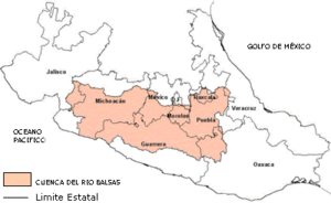
The upper part of the Balsas River basin includes the state of Puebla, the State of Mexico, Morelos, and the Guerrero Mountain Zone. It also includes several river systems from the Mesa Central plateau. The main river system here is the Tlapanec River. It gets water from streams around the Xonacantapec volcano and from the San Jeronimo and Chontalcoatlan rivers. These last two rivers start near the Popocatepetl volcano.
The Balsas River is one of Mexico's longest rivers, stretching about 771 kilometers (479 mi). It begins where the San Martin and Zahuapan Rivers meet in the state of Puebla. Here, it is known as the Atoyac River. From there, it flows southwest and then west through a valley in the state of Guerrero. Finally, it empties into the Pacific Ocean.
The climate in the river basin changes from mild to subtropical. Average yearly temperatures are between 12.5 and 28°C. Most of the rain (about 90%) falls between May and September. Some dry areas of the valley get about 546 mm of rain, while areas further upstream in the highlands get much more, between 1000 and 1600 mm.
How the River Helps People: Development and Dams

The Balsas River basin has seen a lot of economic growth. Many dams have been built to help with irrigation, create electricity, and improve farming. These projects also help the lives of the local people, especially the Nahuas, who are the largest group. There are plans for seven hydropower projects on the Balsas River. Two big ones are the La Villita and El Infiernello dams in Michoacán. The Carlos Ramirez Ulloa (El Caracol) project is in Guerrero, and four more are planned for the future.
Managing the River's Water
The Mexican government has worked hard to manage water resources for many years. This includes using water more efficiently and providing water to major cities. The Tepalcatepec Commission was set up in 1947 to help develop the Balsas River. Later, it became part of the Balsas River Commission. This group helped plan and build irrigation projects, control floods, and generate hydropower. They also worked on rural and urban development and health.
The Balsas River has a strong flow, especially during the rainy season. Its steep slope over a 30 km stretch creates a big drop in elevation (1200 meters). This is perfect for generating hydropower. The La Villita power station first produced 120 MW of power. This station, located near the Pacific Coast in Michoacán, now produces 336 MW. Another big project, El Infiernillo, started working in 1964. It can produce 1,120 MW of power. The El Infiernillo Dam is a huge dam, 149 meters tall.
Farming and Power from the River
Farming in the Balsas basin has a long history, going back over 9,000 years. It has changed from wild grasses to highly productive cornfields.
Two dams on the river are very important for irrigation and making electricity. The water held back by the dam above Tierra Caliente helps grow crops like cotton and rice. The Balsas River basin was first considered for hydropower in the 1940s. The two main projects are La Villita and El Infiernello, both in Michoacán.
The Infiernillo Dam is a massive dam made of rock and earth. It is located about 200 miles (320 km) southwest of Mexico City. It is about 148 meters high and 344 meters long at the top. The reservoir behind it can hold 7,090 million cubic meters of water. This is the largest hydropower project in Mexico and also helps reduce floods in the area.
La Villita is another dam made of earth and rock. It is 60 meters high and 320 meters long at the top. It can generate 300 MW of power. This was the first dam built on the Balsas River, located just 15 km from the Pacific Ocean. Both dams are very strong and have survived five earthquakes, some as strong as magnitude 8.1, since they were built.
Moving Water to Other Areas
A project has been built to move some water from the Balsas River basin to the Lerma River Basin and the Valley of Mexico. This helps provide drinking water to Mexico City, which is about 130 km away. However, moving water between river basins can sometimes lead to disagreements between states in the future.
The Birthplace of Corn
The Balsas Valley is famous for being the place where maize (corn) was first domesticated. This means it's where wild corn was first grown and changed into the corn we know today.
Archaeologist Richard MacNeish first highlighted the importance of the Valley of Tehuacán, which is part of the Balsas valley, for corn domestication. He found over 10,000 ancient corn cobs in the Coxcatlan Cave. Later tests confirmed that these corn samples were very old, dating back about 3,600 BC.
More recent research strongly suggests that the Balsas River valley was indeed the first place in the world where corn was domesticated, about 9,000 years ago. The type of wild grass that is the direct ancestor of corn, called "Balsas teosinte", mostly grows in the middle part of the Balsas Valley today. Scientists are still debating exactly where in the Balsas River valley this special teosinte grew when corn was first domesticated.
Art and Crafts from the Valley
During the Purépecha period, people in the valley made beautiful pottery. It was often reddish-brown with white, cream, or red paintings. They also made ceramic pipes and tools using bronze metals. Today, the native people living in the Balsas River valley are well-known for their amazing bark paintings. These paintings often show colorful flowers and local wildlife.
See also
 In Spanish: Río Balsas para niños
 | Jackie Robinson |
 | Jack Johnson |
 | Althea Gibson |
 | Arthur Ashe |
 | Muhammad Ali |


