Central Mexican matorral facts for kids
Quick facts for kids Central Mexican matorral |
|
|---|---|

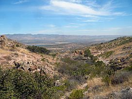
Near Aguascalientes, Mexico
|
|

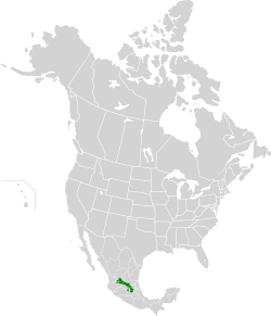
Location map for the Central Mexican matorral
|
|
| Ecology | |
| Realm | Nearctic |
| Biome | deserts and xeric shrublands |
| Borders |
List
|
| Geography | |
| Area | 59,195 km2 (22,855 sq mi) |
| Countries | Mexico |
| States | |
| Conservation | |
| Conservation status | Critical/endangered |
| Protected | 1,288 km² (2%) |
The Central Mexican matorral is a special natural area, or ecoregion, in central Mexico. It is a type of desert and dry shrubland. This ecoregion is the southernmost part of the Nearctic realm, which is a huge natural region covering North America.
Contents
Where is the Central Mexican Matorral?
The Central Mexican matorral covers about 59,400 square kilometers (22,900 square miles). It is located on the southern part of the Mexican Plateau.
The Mexican Plateau and Its Neighbors
The Mexican Plateau is a large, high flat area. To the east, it has the Sierra Madre Oriental mountains. To the south, you'll find the Trans-Mexican Volcanic Belt. The Sierra Madre Occidental mountains are to the west. The Central Mexican matorral covers a big part of the southern plateau. It stretches from the Valley of Mexico in the southeast to the Bolaños River in the northwest.
This matorral area is surrounded by different types of forests. To the east and northeast, there are Sierra Madre Oriental pine-oak forests. The Trans-Mexican Volcanic Belt pine-oak forests are to the southeast. On the northwest, you'll find the Sierra Madre Occidental pine-oak forests. There's even a small, separate part of the Central Mexican matorral in the Valley of Toluca. Higher up in the mountains, you can find "sky islands" of pine-oak forests. These are like isolated patches of forest surrounded by the matorral at lower elevations.
To the southwest, the Central Mexican matorral meets tropical dry forests. These include the Bajío dry forests near the Lerma River and the Sinaloan dry forests near the Río Grande de Santiago river. To the northwest, the Central Mexican matorral changes into the Meseta Central matorral. This area covers the middle part of the Mexican Plateau.
Rivers and Cities
Rivers flow through different parts of the Central Mexican matorral. The eastern part is drained by the Pánuco River. The central part gets water from the Lerma River. The western part is drained by rivers like the Rio Verde and Bolaños. The Valley of Mexico is a special kind of basin. Its water flows into central lakes and doesn't reach the ocean.
Many important cities are located in this ecoregion. These include Mexico City, which is the largest city in North America. Other cities are Toluca, San Luis Potosí, Aguascalientes, Zacatecas, San Miguel de Allende, Dolores Hidalgo, San Juan del Rio, Pachuca, and Actopan.
What is the Climate Like?
The climate here is subtropical and semi-arid. This means it's usually warm, and it doesn't get a lot of rain. Summers are warm with some rain. Winters are cool, especially in places that are higher up.
What Plants Grow Here?
The main type of plants in this area is dry shrubland, which is called matorral. You'll see many types of cacti and plants with leaves shaped like rosettes.
Common Plants
- Cacti: Some common cacti include prickly pear cacti (like Opuntia robusta, Opuntia streptacantha, and Opuntia leucotricha). You might also spot Ferocactus latispinus, Mammillaria magnimamma, and Cylindropuntia imbricata.
- Rosette Plants: These plants have leaves that grow in a circular pattern, like a rose. Examples include agaves such as Agave lechuguilla, and yuccas like Yucca filifera and Yucca decipiens. Other rosette plants are Hechtia podantha and different types of Dasylirion.
- Other Shrubs and Trees: You can also find shrubs and small trees like Schinus molle, Acacia farnesiana, and Mimosa biuncifera.
- Ground Cover: The ground is covered with various grasses and herbs.
In the Valley of Mexico, some of the most common matorral plants are Opuntia streptacantha, Zaluzania augusta, Yucca filifera, Schinus molle, and Mimosa biuncifera. In areas with salty soil, you might see special grasslands and low shrubs. One example is the shrub called romerito (Suadea mexicana).
What Animals Live Here?
The Central Mexican matorral is home to many interesting animals.
Mammals
Some native mammals include:
- White-tailed deer (Odocoileus virginianus)
- Coyote (Canis latrans)
- Collared peccary (Pecari tajacu)
- Nine-banded armadillo (Dasypus novemcinctus)
- Virginia opossum (Didelphis virginiana)
- Southern spotted skunk (Spilogale angustifrons)
- Mexican cottontail (Sylvilagus cunicularius)
- Desert cottontail (Sylvilagus audubonii)
- Rock squirrel (Otospermophilus variegatus)
Birds
Many different birds also live in this ecoregion:
- Great-tailed grackle (Quiscalus mexicanus)
- Mourning dove (Zenaida macroura)
- Stygian owl (Asio stygius)
- Red-tailed hawk (Buteo jamaicensis)
- Northern harrier (Circus cyaneus)
- Prairie falcon (Falco mexicanus)
- Harris's hawk (Parabuteo unicinctus)
- Barn owl (Tyto alba)
- Hooded oriole (Icterus cucullatus)
- Common raven (Corvus corax)
Protected Areas
About 5.4% of this ecoregion is set aside as protected areas. These areas help keep the plants and animals safe. Some of these protected places include:
- El Gogorrón National Park
- Sierra Gorda Biosphere Reserve
- Sierra Gorda de Guanajuato Biosphere Reserve
- El Cimatario National Park
- Los Remedios National Park
- El Tepeyac National Park
- Molino de Flores Netzahualcóyotl National Park
- Sierra de Lobos Sustainable Use Area
- Ciénegas de Lerma
- Sierra de Álvarez Flora and Fauna Protection Area
- Cuenca Alimentadora del Distrito Nacional de Riego 043 Estado de Nayarit (Natural Resources Protection Area)
- Cuenca Alimentadora del Distrito Nacional de Riego 01 Pabellón (Natural Resources Protection Area)
See also
 In Spanish: Matorral central mexicano para niños
- List of ecoregions in Mexico
 | DeHart Hubbard |
 | Wilma Rudolph |
 | Jesse Owens |
 | Jackie Joyner-Kersee |
 | Major Taylor |

