Toluca Valley facts for kids
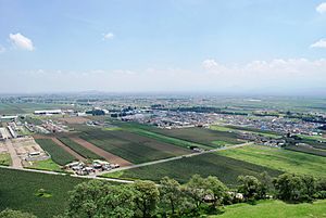
The Toluca Valley is a large valley in central Mexico. It sits just west of the Valley of Mexico (where Mexico City is). Long ago, its old name was Matlatzinco. This valley stretches about 35 kilometers from north to south. Tall mountains surround it, with the huge Nevado de Toluca Volcano being the most impressive. The Toluca Valley is one of the highest valleys in Mexico. Because of its high elevation, it has a rather cold climate.
Since the 1940s, the valley has seen a lot of environmental damage. Forests have been lost, soil has eroded, and water levels have dropped. Water pollution has also increased. This damage is due to the growth of industries and a larger population. In ancient times, before the Spanish arrived, the valley was a buffer zone. It was located between the powerful Aztec Empire and the Purépecha Empire. From the Aztec period until the 1800s, Mexico City controlled this area. Today, it is the heart of the State of Mexico, and its capital city, Toluca, is the main city in the valley.
Contents
Valley's Location and Weather
The Toluca Valley is a wide highland valley. It is right next to the Valley of Mexico on its west side. It's one of Mexico's highest valleys, sitting about 2,570 meters above sea level (masl). The valley is part of the Trans-Mexican Volcanic Belt. Its soils are made from volcanic rock, mostly from the Upper Cenozoic era.
The mountain sides have older volcanic rocks like basalt and andesite. They also have ash and rock fragments. The valley floor is made of materials from old lakes and rivers. The valley covers about 700 square kilometers. It runs north to south for 35 km and is about 20 km wide.
- Its northern edge has the Guadalupana Volcano and Cerro el Aguila.
- The southern part has the Tenango and Zempoala Volcanoes.
- To the east are the Sierra de Las Cruces and La Iglesia mountains.
- The west side is defined by the Nevado de Toluca and Sierra Morelos.
These mountains and the valley's high elevation make the area cooler.
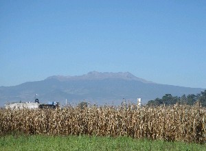
The most famous mountain nearby is the Nevado de Toluca. It stands 4,690 masl to the southwest. This volcano is the fourth highest mountain in Mexico. It was formed by many eruptions that piled up layers of igneous rock. Its peak often has snow for most of the year. Temperate forests surround the mountain. The Nevado de Toluca greatly affects the valley's weather and water.
The lower slopes of the mountains have hills covered in broadleaf forests. Higher up, you find conifer trees. The very highest parts have alpine grasslands, called Zacatonal. Even though the valley is in a tropical zone, its high altitude makes it cold. Cold air also comes from the Sierra de Las Cruces and Nevado de Toluca. The average monthly temperature changes from 5°C at over 3,000 meters to 20°C lower in the valley.
The climate is called a sub-humid temperate climate. It has a long summer and very little rain in winter. The area has a rainy season and a dry season. The rainy season lasts from mid-May to mid-October. Most rain falls on the sides of the Nevado de Toluca, up to 1,200 mm per year. The valley floor gets about 900 mm per year. Almost all the rain happens during the rainy season, mostly in June. There's a short dry period in August before rains return in September.
The Toluca Valley is part of the upper Lerma River. This river is the main source of water on the surface.
Valley's Government and People
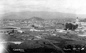
The Toluca Valley is in the southeastern part of the State of Mexico. This state covers most of the state's land. It is the most populated state in Mexico, with over 14 million people. Historically, the state's focus was on Mexico City. But after Mexico City became a separate Federal District, the state's political center moved to the Toluca Valley. The city of Toluca became its capital.
Today, most of the state's people still live near the Mexico City metropolitan area. However, the second largest group of people lives in the Toluca Valley. Over 1,350,000 people live in the valley. Sixty percent of them live in the Toluca metropolitan area. The rest live in the valley's more than 400 other communities. Because of this political change, the Nevado de Toluca volcano has become a cultural symbol for the State of Mexico.
Economy and Environmental Challenges
Until the mid-1900s, the main jobs in the valley were farming and forestry. This was because of the large forests, fertile soils, and the Lerma River. Industries started to grow in the valley in the 1940s. This growth sped up in the 1950s and 1960s. The valley's population grew more than four times from 1930 to 2000. This growth was much faster than the rest of the country.
Today, the valley is an important industrial area with many people living close together. Most of the area is now urbanized. In 1950, 60% of workers were in farming. By 2000, less than 7% were. Now, most people work in industry and trade, especially in the Toluca area. The remaining farming is mostly for families to feed themselves. It happens only during the rainy season. These fast changes have led to environmental damage.
Most of the original wild plants were valuable temperate forests. But much of this forest has disappeared. Since the late 1900s, over 10,000 hectares of forests have vanished. Another 10,000 hectares have become much less dense. The Nevado de Toluca National Park was created in 1936. Its goal was to protect 51,000 hectares around the Nevado de Toluca volcano, also known as Xinantécatl. Despite being a protected area, the Nevado de Toluca park has lost half its trees since it was created. This is mostly due to illegal logging. Over 75% of the land has some level of erosion damage.
Many farm lands have been replaced by housing. These homes are mostly for workers in the area's industries. City growth has been unplanned. There are no good road or public transport systems. This causes traffic jams, especially in Toluca. In the 2000s, new roads were built to go around Toluca. These roads make it easier to cross the valley and connect it better with Mexico City. They also link to Michoacán in the west and Cuernavaca in the south.
More industries and people have put a lot of stress on fresh water supplies. They have also caused water pollution. Pumping too much water from underground has made the ground sink. It has sunk over two meters since 1962. It lost about 40 cm just from 2003 to 2008. Pumping water and taking water from springs to send to Mexico City has reduced surface water. There is a yearly shortage of 56 to 89 million cubic liters of water. This has made springs disappear in Almoloya del Río, Alta Empresa and Ameyalco. Even parts of the Lerma River dry up in the dry season.
The loss of water has made shallow lakes and wetlands along the Lerma River disappear. This has destroyed entire water ecosystems. In 1943, there were 10,705 hectares of wetlands. Today, only 3,000 hectares flood during the rainy season. The dried-up lagoon lands have become farmland. Also, the quality of the remaining water has gotten worse since the 1940s. This is due to dirty water from cities and industries. The Lerma River and other channels are used for drainage. So, the pollution level is very high. It is worse than government rules for water used for fun, protecting plants and animals, or industrial uses. High levels of heavy metals are a big problem in the Lerma River above the Alzate Dam.
History of the Valley
People likely started living in central Mexico around 12,000 BCE. By the 12th century CE, many different groups lived in the Toluca Valley. We don't know much about the valley's history before the Spanish arrived, especially before the Aztecs. This is mainly because the Aztecs destroyed many old documents when they became powerful. One important old document is the Codex García Granados. It describes events in the Toluca Valley in three periods: a "legendary period," the rule of the Tepanac king Tezozomoc, and the Aztec period.
There are two important ancient sites in the valley.
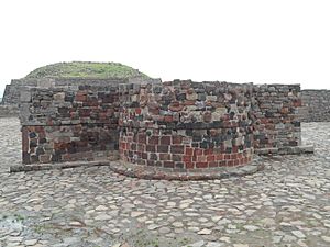
- On the south end is Teotenango. A group called the Teotenaca founded it near the end of the Teotihuacan period. Later, the Matlazinca people took it over and made it bigger. The city lasted for about 1,000 years. It was only abandoned after the Spanish Conquest of the Aztec Empire.
- Calixtlahuaca is in the north of the valley, just north of today's Toluca. It dates back to the Toltec period. By the late 1400s, it was a strong city-state. It controlled much of the Toluca Valley and was the main target for Aztec conquest.
In the Post Classic period (900-1519 CE), many languages were spoken in the valley. These included Matlatzinca, Mazahua, Otomi, and Nahuatl. Aztec mythology mentions Matzalinco in stories about their journey to the Valley of Mexico. This likely refers to Nahuatl speakers who settled in the Toluca Valley in the 1200s. Five towns in the valley are mentioned often in native histories: Cuahuacan, Malinalco, Matlazinco, Teotenanco, and Xilotepec. This shows they were important settlements long before the Aztec conquest.
Much of the Toluca Valley was probably part of the earlier Tepanec Empire. This empire was based in Azcapotzalco and was strongest around 1370. Several Toluca Valley towns were under Tepanec rule. The historical records about the Toluca area before the Aztecs are not clear. This is because the Aztecs destroyed many documents. From 1428 to 1470, Toluca Valley towns do not appear much in Aztec records. The names Tollocan (Toluca) and Matlatzinco seem to refer to the same area in records. But it's not known if they meant the same city or state. By 1475, just before the Aztec conquest, it was clear they were two different city-states.
At first, the Aztec Empire mostly ignored the Toluca Valley. But then the Purépecha Empire started to move into the area in the mid-1400s. Most of the valley was conquered by the Aztec emperor Axayacatl. The Tizoc Stone shows Emperor Tizoc defeating a warrior from this area. The first conquest wave was in the Mazahua region in the north of the valley in 1473. Then, Matlazinco/Tollocan was conquered in 1475. Toluca Valley town names began to appear in Aztec records. Matlatzinco was renamed Calixtlahuaca. In 1476 or 1477, the Aztecs fought the Purépecha armies on the western edge of the Toluca Valley. But the Aztecs lost badly. Rebellions broke out in the Toluca Valley, and Axayacatl had to return to conquer the people again.
Tenochtitlan, the Aztec capital, ruled this area more directly than other parts of the Empire. They created smaller states on the border with the Purépecha. Toluca became the main center for the valley. People from the Valley of Mexico were encouraged to move to the Toluca Valley. There was some control of rebellions under a later emperor, Ahuitzotl. But there was no major fighting in the valley again until the Spanish conquest.
When the Spanish conquered the Aztec Empire, the Toluca Valley paid tribute to the Aztecs. It was also a buffer zone between the Aztec and Purépecha empires. Gonzalo de Sandoval conquered most of the area for the Spanish. He had help from Otomi allies. Hernán Cortés’ cousin, Juan Altamirano, was given control of the Toluca Valley. Franciscan missionaries arrived soon after. People like Martin de Valencia, Juan de Tecto, Juan de Ahora, and Pedro de Gante set up missions. They also started the first school called San Antonio de Padua. Spanish colonial rule followed the old pre-conquest areas. Former city-states became cabeceras (head-towns). The former Aztec empire became the audencia of Mexico. It was centered on Mexico City and grew to include the Toluca Valley. It also expanded south and west into the modern states of Guerrero and Morelos.
From the 1800s to Today
After Mexico became independent, the next big political change for the valley happened in the mid-1800s. The State of Mexico was divided into new states. The Mexico City area was made into the Federal District. This process gave the State of Mexico its current shape. Its political and cultural center moved to the Toluca Valley. The city of Toluca became its capital. Since then, the valley's growth in politics, economy, and culture has focused on this city.
Even with the damage from lots of building and population growth, there are still very beautiful natural areas. About 3.5 million visitors come each year, mostly from Mexico. These places include parts of La Marquesa Park, El Nevado de Toluca, Zacango Zoo, Sierra Morelos Park, Tecula, and the Lagunas de Zempoala. The volcano was once a sacred place in older religions. It is a cultural symbol for the valley and the State of Mexico.
The area also has many old buildings from the colonial period. These include hacienda houses, churches, and old monasteries. There are also mansions from the time of Porfirio Díaz. Many of these are now museums or other cultural places.
Biology: Potato Late Blight
Scientists who study plant diseases know the Toluca Valley as the place where the potato late blight pathogen first appeared. This pathogen is called Phytophthora infestans. It is famous for causing the terrible Great Irish Famine in the mid-1840s.
See also
 In Spanish: Valle de Toluca para niños
 | Emma Amos |
 | Edward Mitchell Bannister |
 | Larry D. Alexander |
 | Ernie Barnes |


