Nevado de Toluca facts for kids
Quick facts for kids Nevado de Toluca |
|
|---|---|
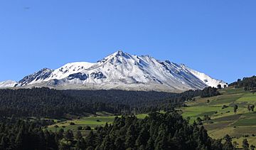
Nevado de Toluca as seen from Lerma (southeast).
|
|
| Highest point | |
| Elevation | 4,680 m (15,350 ft) |
| Prominence | 2,210 m (7,250 ft) |
| Isolation | 118.39 km (73.56 mi) |
| Parent peak | Popocatépetl |
| Listing |
|
| Geography | |
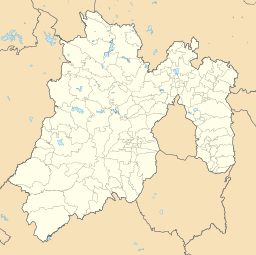
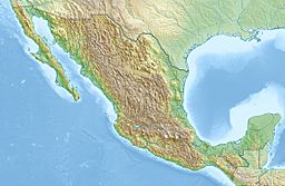
| Location | Texcaltitlán, México, Mexico |
| Geology | |
| Mountain type | Stratovolcano |
| Volcanic arc/belt | Trans-Mexican Volcanic Belt |
| Last eruption | 1350 BCE (?) |
| Climbing | |
| Easiest route | road, hiking trail |
Nevado de Toluca is a huge stratovolcano (a cone-shaped volcano built up by many layers of hardened lava and ash) in central Mexico. It is about 80 kilometers (50 miles) west of Mexico City, close to the city of Toluca. This volcano is the fourth highest peak in Mexico. Only Pico de Orizaba, Popocatépetl, and Iztaccíhuatl are taller. Today, the volcano and the area around it are part of a national park.
Contents
What Does "Nevado de Toluca" Mean?
This volcano is often called Xinantecatl, which is a name from the Nahuatl language. People have suggested different meanings for this name. Some thought it meant "Lord of the Corn Stalks." Others believed it was Tzinacantecatl or Zinacantepetl, meaning "Mountain of the Bats."
However, new discoveries from archaeological digs have helped us understand its true meaning. It is now believed that the correct name is Chicnauhtecatl. This means "Lord of Nine." It probably refers to the nine deep lakes found at the top of the volcano.
Exploring the Volcano's Features
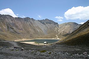
The top of Nevado de Toluca has a wide basin called a caldera. This caldera is about 1.5 kilometers (0.9 miles) wide and opens towards the east.
Peaks and Lakes at the Summit
The highest point of the volcano is called Pico del Fraile (Friar's Peak). It stands at 4,680 meters (15,354 feet) high. This peak is on the southwest side of the crater. The second highest point is Pico del Aguila (Eagle's Peak). It is 4,640 meters (15,223 feet) tall and is on the northwest side.
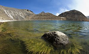
Inside the caldera, there are two beautiful crater lakes. They are located at about 4,200 meters (13,780 feet) above sea level. The larger lake is called Lago del Sol (Sun Lake). The smaller one, Lago de la Luna (Moon Lake), is deeper.
There used to be a road that went all the way to these lakes. Now, a gate blocks the road about 2 kilometers (1.2 miles) before you reach the lakes.
A Mountain of Legends
From the southeast, Nevado de Toluca looks flat on top, almost like shoulders without a head. An old Nahuatl legend helps explain this unique shape. This story is part of the larger legend of Popocatépetl and Iztaccíhuatl.
How the Volcano Was Formed
Scientists believe that Nevado de Toluca might have once been as tall as Popocatépetl. But about 25,000 years ago, a huge eruption blew off the top of the volcano. This event made it about 900 meters (2,953 feet) shorter!
Past Eruptions and Their Effects
The same eruption created thick mudflows, also known as lahars. These mudflows covered the sides of the mountain. About 500 years later, another eruption spread layers of light, porous rock called pumice on the east and northeast slopes.
The last major eruption of Nevado de Toluca happened about 10,500 years ago. This eruption was very powerful, similar to the 1991 eruption of Mount Pinatubo. It covered the city of Toluca with 1.5 meters (5 feet) of pebble-sized pumice. The Mexico City region received about 50 centimeters (1.6 feet) of sand. Mudflows from this eruption even carried mammoth bones and other animal remains into the basin of Mexico.
After this, a volcanic plug (a blockage of hardened lava) formed inside the volcano's opening. This plug stopped the volcano from erupting again. It eventually became known as El Ombligo, which means "the Navel."
Understanding the Climate
Near the top, Nevado de Toluca has a cold alpine climate. This means temperatures are cold all year round. There isn't much change in how warm or cold it gets. Frost and snow can happen in any month.
Seasons and Weather Patterns
The winter season runs from November to April. During this time, there is not much rain or snow. March is the driest month, with only about 12.4 millimeters (0.5 inches) of precipitation. Temperatures are cold, averaging 2.3°C (36.1°F) in January.
The summer season is from May to October. This is when the volcano gets a lot of rain. July is the wettest month, with about 243.5 millimeters (9.6 inches) of precipitation. Temperatures are warmer, averaging 5.2°C (41.4°F) in May.
The summit is often foggy, with fog occurring about 110 days a year. Most of the fog happens during the rainy season. The most precipitation recorded in one month was 513.5 millimeters (20.2 inches) in July 2008. The most in one day was 90.5 millimeters (3.6 inches) on July 16, 1999. The highest temperature ever recorded was 23°C (73.4°F) on August 16, 1993. The lowest was -10°C (14°F) on February 2, 2004.
| Climate data for Nevado de Toluca, elev. 4,283 metres (14,052 ft) | |||||||||||||
|---|---|---|---|---|---|---|---|---|---|---|---|---|---|
| Month | Jan | Feb | Mar | Apr | May | Jun | Jul | Aug | Sep | Oct | Nov | Dec | Year |
| Record high °C (°F) | 15.0 (59.0) |
16.5 (61.7) |
19.0 (66.2) |
18.0 (64.4) |
19.3 (66.7) |
19.0 (66.2) |
21.0 (69.8) |
23.0 (73.4) |
16.0 (60.8) |
19.0 (66.2) |
14.0 (57.2) |
12.0 (53.6) |
23.0 (73.4) |
| Mean daily maximum °C (°F) | 7.1 (44.8) |
7.6 (45.7) |
9.5 (49.1) |
10.2 (50.4) |
10.0 (50.0) |
9.4 (48.9) |
8.3 (46.9) |
8.2 (46.8) |
8.1 (46.6) |
8.0 (46.4) |
7.4 (45.3) |
7.0 (44.6) |
8.4 (47.1) |
| Daily mean °C (°F) | 2.3 (36.1) |
2.8 (37.0) |
4.3 (39.7) |
5.1 (41.2) |
5.2 (41.4) |
5.0 (41.0) |
4.4 (39.9) |
4.3 (39.7) |
4.2 (39.6) |
3.8 (38.8) |
3.0 (37.4) |
2.4 (36.3) |
3.9 (39.0) |
| Mean daily minimum °C (°F) | −2.5 (27.5) |
−2.1 (28.2) |
−0.8 (30.6) |
0.1 (32.2) |
0.3 (32.5) |
0.7 (33.3) |
0.5 (32.9) |
0.4 (32.7) |
0.4 (32.7) |
−0.4 (31.3) |
−1.4 (29.5) |
−2.1 (28.2) |
−0.6 (30.9) |
| Record low °C (°F) | −7.5 (18.5) |
−10.0 (14.0) |
−8.0 (17.6) |
−6.0 (21.2) |
−5.0 (23.0) |
−4.0 (24.8) |
−4.0 (24.8) |
−7.0 (19.4) |
−5.0 (23.0) |
−9.0 (15.8) |
−6.5 (20.3) |
−8.5 (16.7) |
−10.0 (14.0) |
| Average precipitation mm (inches) | 15.3 (0.60) |
13.2 (0.52) |
12.4 (0.49) |
56.4 (2.22) |
116.4 (4.58) |
204.6 (8.06) |
243.5 (9.59) |
228.1 (8.98) |
208.4 (8.20) |
87.8 (3.46) |
27.1 (1.07) |
15.1 (0.59) |
1,228.3 (48.36) |
| Average precipitation days (≥ 0.1 mm) | 2.7 | 2.6 | 2.5 | 6.6 | 13.4 | 19.9 | 24.5 | 23.0 | 21.2 | 12.6 | 4.5 | 3.0 | 136.5 |
| Source: Servicio Meteorológico Nacional | |||||||||||||
Ancient Secrets: Archeological Sites
There are 18 registered archeological sites within the national park. This area was a very important place for rituals and ceremonies long ago, before the Spanish arrived. Bernardino de Sahagún, a famous historian, wrote that the local people held special ceremonies and made sacrifices at the lakes.
Offerings in the Lakes
The lakes themselves are considered two important sites. Many offerings, especially a type of incense called copal, were placed in the lakes. People would burn the copal and let it float on the water until it sank. Other items like pottery and carved stones have also been found. In the past, divers sometimes took these ancient pieces. Now, authorities carefully watch anyone who dives in the lakes.
Sites on the Crater Walls
Most of the other archeological sites are found on the crater's walls and peaks.
- One site is called Xicotepec. It is on top of a rocky dome known as Cerro de Ombligo ("the navel"). Here, archaeologists have found green obsidian blades and colorful pottery.
- On the north side of the crater is Pico Sahagun, where pottery pieces have been found.
- Picos Heilprin North and South have also revealed various ancient objects.
- El Mirador is another site. It is thought to be connected to tracking the sun's highest point in the sky, called the zenith. A stone slab, or stele, found here seems to support this idea.
- The highest site is Pico Noreste, at 4,130 meters (13,550 feet) above sea level. It's a small platform where badly damaged pottery pieces were found.
- On the west side is the Cerro Prieto Cave. This is a large rock shelter, over 60 meters (197 feet) high. It shows signs of visits from ancient times. It has also been a shrine to the Archangel Michael since the time of the Spanish colonies.
Recent Discoveries
Archaeological digs have happened here on and off. The most recent ones were in 2010, supported by INAH (Mexico's National Institute of Anthropology and History). These digs found artifacts from the Epi-Classic period (650-900 AD) and the Post-Classic period (900-1200 AD). The findings showed that the volcano's crater was a meeting place for astronomer priests. They would gather there to predict the best times for planting crops.
Gallery
See also
 In Spanish: Nevado de Toluca para niños
- List of mountain peaks of North America
- List of mountain peaks of Mexico
- List of volcanoes in Mexico
- List of Ultras of Mexico
- List of mountain peaks of Mexico
- Nevado de Toluca National Park
- Arqueologia Mexicana
 | Delilah Pierce |
 | Gordon Parks |
 | Augusta Savage |
 | Charles Ethan Porter |


