Mount Pinatubo facts for kids
Quick facts for kids Mount Pinatubo |
|
|---|---|
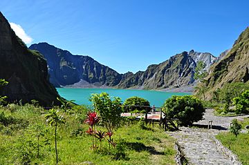
Mount Pinatubo crater lake in 2012
|
|
| Highest point | |
| Elevation |
|
| Listing | Active volcanoes in the Philippines |
| Naming | |
| Language of name | Tagalog |
| Geography | |
| Location | Luzon |
| Country | Philippines |
| Region | Central Luzon |
| Provinces | |
| Parent range | Zambales Mountains |
| Geology | |
| Age of rock | Between 635,000 ± 80,000 and 1.1 ± 0.09 million years |
| Mountain type | Stratovolcano |
| Volcanic arc/belt | Luzon Volcanic Arc |
| Last eruption | November 30, 2021 |
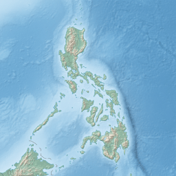
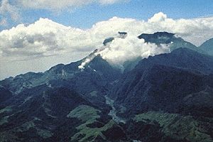
Mount Pinatubo is an active stratovolcano, which is a cone-shaped volcano, located in the Zambales Mountains in the Philippines. It sits where three provinces meet: Zambales, Tarlac, and Pampanga, all on the northern island of Luzon. For a long time, people didn't know much about its past eruptions. Before 1991, thick forests covered Pinatubo, hiding it from view. Thousands of Aeta people, who are indigenous to the area, lived on its slopes.
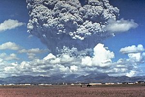
Mount Pinatubo is famous for its huge VEI-6 eruption on June 15, 1991. This was the second-largest land eruption of the 20th century. A powerful storm, Typhoon Yunya, hit at the same time. This made things even worse, bringing a dangerous mix of ash and rain to nearby towns. Luckily, scientists predicted the eruption, and tens of thousands of people were moved to safety. This saved many lives.
The areas around the volcano were badly damaged by fast-moving flows of hot ash and gas called pyroclastic surges. Later, heavy rains caused lahars, which are mudflows made of volcanic ash and water. These lahars destroyed buildings and changed river paths for years. Smaller eruptions that formed a lava dome inside the volcano's crater continued from 1992 to 1993.
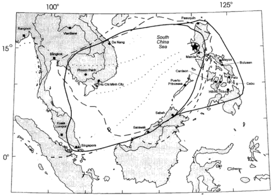
The effects of the 1991 eruption were felt all over the world. The volcano shot out about 10 billion tons of magma and 20 million tons of sulfur dioxide gas. This sent a lot of tiny particles into the stratosphere, which is a high layer of Earth's atmosphere. This was more than any eruption since Krakatoa in 1883. These particles formed a global layer of sulfuric acid haze. Because of this, global temperatures dropped by about 0.5°C (0.9°F) between 1991 and 1993. There was also a temporary increase in ozone depletion.
Contents
Where is Mount Pinatubo Located?
Mount Pinatubo is about 87 kilometers (54 miles) northwest of Manila, the capital city of the Philippines. Close to the volcano were large military bases used by the United States. The U.S. Naval Base Subic Bay was 37 kilometers (23 miles) south of Pinatubo. Clark Air Base was just 14 kilometers (9 miles) east of the volcano's top. About 6 million people live near the volcano.
The Long History of Pinatubo
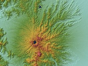
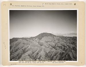
Before the 1991 eruption, Mount Pinatubo's peak was 1,745 meters (5,725 feet) above sea level. It was only about 600 meters (2,000 feet) higher than the nearby flat lands. It was also only about 200 meters (660 feet) taller than other peaks around it, which often hid it from view. Pinatubo is part of a chain of volcanoes along the western side of Luzon island. This chain is called the Zambales Mountains.
Pinatubo is part of the Cabusilan sub-range within the Zambales Mountains. These volcanoes are called subduction volcanoes. They form when one of Earth's huge tectonic plates, the Eurasian Plate, slides under another, the Philippine Mobile Belt. This happens along the Manila Trench to the west. The magma that forms Mount Pinatubo and other volcanoes in this area comes from this process.
Scientists have studied Mount Pinatubo for a long time. In the 1980s, a geologist named F. G. Delfin studied the mountain. He found that Pinatubo had two main stages in its life: "ancestral" Pinatubo and "modern" Pinatubo.
Ancestral Pinatubo: The Old Volcano
Ancestral Pinatubo started forming about 1.1 million years ago. It likely stopped erupting tens of thousands of years before "modern" Pinatubo began. Much of the rough land around today's volcano is what's left of this older volcano. Ancestral Pinatubo was a stratovolcano made of andesite and dacite rock. Its eruptions were not as explosive as modern Pinatubo's. Its center was roughly where the current volcano is. Scientists think it might have been as tall as 2,300 meters (7,500 feet).
The old volcano's remains can be seen in the walls of a large, old crater called the Tayawan Caldera. Some nearby peaks are also parts of ancestral Pinatubo. These were left behind after softer parts of the old mountain were worn away by weather. Ancestral Pinatubo is like a "somma volcano," which means it's an old volcano with a new, smaller cone (modern Pinatubo) growing inside it.
Modern Pinatubo: The Younger Volcano
- Around 79,000 BC: After a long quiet period, modern Pinatubo was born. This happened during its most explosive eruptions, which were about five times bigger than the 1991 eruption. These eruptions covered the area around the volcano with up to 25 cubic kilometers (6 cubic miles) of volcanic material. So much material was removed from the magma chamber below that the Tayawan caldera formed. This violent period is called the Inararo Eruptive Period.
After this, modern Pinatubo erupted sometimes, but the quiet periods between eruptions were much longer than the eruption times. Other major eruptions happened around:
- c. 15,000 BC (Sacobia Eruptive Period)
- c. 7000 BC (Pasbul Eruptive Period)
- c. 4000–3000 BC (Crow Valley Eruptive Period)
- c. 1900–300 BC (Maraunot Eruptive Period)
- c. AD 1500 (Buag Eruptive Period)
Each of these eruptions was very large, throwing out more than 10 cubic kilometers (2.4 cubic miles) of material. They covered huge areas with hot ash and rock flows. Some eruption periods lasted for decades or even centuries.
The biggest eruptions in each period have become smaller over modern Pinatubo's 35,000-year history. The oldest eruption, Inararo, was also the largest. The 1991 eruption was actually one of the smallest recorded in its long history.
The volcano hasn't grown very large between eruptions. This is because it produces soft, easily eroded deposits. It also regularly destroys the thick lava domes that form in its vents. After the Buag eruption (around 1500 AD), the volcano was quiet for about 500 years. Its slopes became completely covered in thick rainforest and were carved by rivers.
The 1991 Eruption: A Global Event
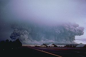
On June 12, 1991, at 3:41 AM, a small explosion signaled a new, more violent phase. A few hours later, huge blasts lasted about half an hour. They created massive ash columns that quickly reached over 19 kilometers (62,000 feet) high. These blasts also caused large pyroclastic surges that spread up to 4 kilometers (2.5 miles) from the top of the volcano. Fourteen hours later, another blast threw volcanic material 24 kilometers (15 miles) high. The friction in the rising ash column created a lot of volcanic lightning.
In March and April 1991, magma began moving up from deep inside Pinatubo, more than 32 kilometers (20 miles) down. This caused small volcano tectonic earthquakes and powerful steam explosions. These explosions created three new craters on the north side of the volcano. Thousands of small earthquakes continued under Pinatubo through April, May, and early June. The volcano also released thousands of tons of harmful sulfur dioxide gas.
From June 7 to 12, the first magma reached the surface. It had lost most of its gas, so it oozed out to form a lava dome instead of exploding. But on June 12, millions of cubic yards of gas-filled magma reached the surface. This caused the volcano's first spectacular explosion.
When even more gas-filled magma reached the surface on June 15, the volcano exploded in a massive eruption. It threw out more than 5 cubic kilometers (1.2 cubic miles) of material. The ash cloud from this eruption rose 35 kilometers (22 miles) into the atmosphere. Lower down, a typhoon's strong winds blew the ash in all directions. Higher up, winds blew the ash southwest. A thick layer of ash and larger pumice rocks covered the countryside. Fine ash fell as far away as the Indian Ocean. Satellites tracked the ash cloud as it traveled around the world several times.
Huge pyroclastic flows rushed down Pinatubo's sides. They filled once-deep valleys with fresh volcanic deposits up to 200 meters (660 feet) thick. The eruption removed so much magma and rock from under the volcano that the summit collapsed. This formed a 2.5-kilometer (1.6-mile) wide crater called a caldera.
After the main eruption on June 15, 1991, the volcano's activity became much lower. Ash eruptions continued until August 1991, and occasional eruptions lasted for another month.
Later Eruptions and Lake Pinatubo
The volcano remained quiet until July 1992. Then, a new lava dome started growing inside the caldera. Scientists thought more big eruptions might happen, so some areas were evacuated again. However, this eruption was only minor. The last eruption of Mount Pinatubo happened in 1993.
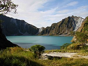
After the 1991 eruption, the caldera filled with water from annual monsoon rains. This created a beautiful crater lake called Lake Pinatubo. In 1992, a growing lava dome formed an island in the lake, which was later covered by the water. At first, the lake was hot and very acidic, with a pH of 2 and a temperature of about 40°C (104°F). Over time, rainfall cooled and diluted the lake. By 2003, the temperature dropped to 26°C (79°F), and the pH rose to 5.5.
The lake grew deeper by about 1 meter (3.3 feet) each month. By September 2001, people worried that the crater walls might not be strong enough to hold the water. So, the Philippine government decided to drain some of the lake in a controlled way. About 9,000 people were moved from nearby areas in case a large flood happened by accident. Workers cut a 5-meter (16-foot) notch in the crater rim and drained about a quarter of the lake's water.
Recent Activity of Pinatubo
On July 10, 2002, the west wall of the crater collapsed. This slowly released about 160 million cubic meters (5.7 billion cubic feet) of water and mud into the Maraunot River.
On July 26, 2011, a 5.9 magnitude earthquake happened near Pinatubo. No major damage or injuries were reported.
On March 4, 2021, the PHIVOLCS (Philippine Institute of Volcanology and Seismology) raised the alert level for Mount Pinatubo to Level 1. This was because of an increase in earthquake activity. Since January 2021, 1,722 volcanic earthquakes were recorded near the volcano.
However, on August 11, 2021, PHIVOLCS lowered the alert level back to Level 0. This was because the earthquake activity had decreased and returned to normal levels. PHIVOLCS noted a "significant decrease" in volcanic earthquakes, with only 104 quakes recorded from July 1 to August 1, 2021.
On November 30, 2021, PHIVOLCS reported a small explosion on Mount Pinatubo. It happened between 12:09 PM and 12:13 PM and created a plume of steam. The agency later confirmed it was a phreatic explosion. This means it was caused by hot water and steam near the surface, not by new magma.
Cultural History and Legends
The word pinatubo can mean "fertile place where crops can grow" or "made to grow" in the Sambal and Tagalog languages. This might suggest that people knew about its eruption around 1500 AD. There are also local stories passed down through generations about earlier large eruptions. One old legend tells of Bacobaco, a scary sea spirit. He could turn into a giant turtle and breathe fire. The legend says that when hunters chased Bacobaco, he ran to the mountain. He dug a huge hole in its top, showering the land with rocks, mud, dust, and fire for three days. He howled so loudly that the earth shook.
Pinatubo's History Among the Aeta People
Aeta elders share many stories about the mountain's history. The most famous one says it was once a "Batung Mabye" (Kapampangan for "living stone"). A displeased sorcerer supposedly planted it on a kingdom, but a hero moved it. The mountain then became the home of Apo Namalyari, the god of the Sambal, Aetas, and Kapampangans living in the Zambales range.
It was said that Apo Namalyari's domain covered the whole mountain range. But then Sinukuan of Mount Arayat (the god of the Kapampangans) became a strong rival. Their fight, which happened over the central plains, broke the mountain into smaller pieces. Mount Arayat also lost its central peak. Other stories say Pinatubo's peak shattered because of Namalyari's great anger. He wanted to teach humans about fear and show how bad deeds would be punished.
According to the native elders, Apo Namalyari caused the June 1991 eruption. They believe he was unhappy with illegal loggers and executives from the Philippine National Oil Company. These companies had been drilling deep into the volcano from 1988 to 1990, looking for geothermal energy. The drilling results were not good, so the project was stopped 13 months before the explosions began in April 1991.
Aeta People Gain Ownership of Pinatubo Land
After being forced to leave their homes by the 1991 eruption, many Aeta families faced challenges. In May 2009, about 454 Aeta families in Pampanga received the first official land ownership title for their ancestral land on Mount Pinatubo. This was called a Certificate of Ancestral Domain Title (CADT). It was given by the National Commission on Indigenous Peoples (NCIP), a government agency that helps indigenous people in the Philippines. This title covered about 7,440.1 hectares (18,385 acres) of land. It included parts of Floridablanca, Pampanga, and parts of San Marcelino and Subic in Zambales.
On January 14, 2010, about 7,000 Aeta families from Zambales also received their CADT. This title covered the Zambales side of Pinatubo, including the summit and Lake Pinatubo. This officially made it their lutan tua (ancestral land). This ancestral domain title covers 15,984 hectares (39,500 acres). It includes villages like Burgos, Villar, Moraza, and Belbel in Botolan, and parts of Cabangan, San Felipe, and San Marcelino.
Having these land titles helps protect the Aeta people. It prevents others, including foreigners, from using their land without their permission or paying them. In the past, Aetas had problems with mining companies, loggers, and tourist companies. These groups made money from Mount Pinatubo but did not share it with the local tribes.
Ancestral domain titles are given to communities or indigenous groups. These groups must have lived on or used the land continuously for a very long time, following their own customs. This gives them the legal right to own and use the land and its natural resources together, and to prevent others from doing so.
Hiking and Tourism
The caldera formed by the 1991 eruption, and Lake Pinatubo within it, has become a popular tourist spot. Many people visit the lake by hiking through Barangay Santa Juliana in Capas, Tarlac.
Images for kids
See also
 In Spanish: Pinatubo para niños
- List of volcanoes in the Philippines
- List of active volcanoes in the Philippines
- List of potentially active volcanoes in the Philippines
- List of inactive volcanoes in the Philippines
- List of volcanic eruptions by death toll
- Timeline of volcanism on Earth
 | Emma Amos |
 | Edward Mitchell Bannister |
 | Larry D. Alexander |
 | Ernie Barnes |


