
Krakatoa facts for kids
Quick facts for kids Krakatoa |
|
|---|---|

A lithograph of the 1883 eruption of Krakatoa
|
|
| Highest point | |
| Listing | Spesial Ribu |
| Geography | |

Krakatoa
Location in Indonesia
|
|
| Location | Indonesia |
| Geology | |
| Mountain type | Caldera |
| Last eruption | 15 September 2023 |
Krakatoa, also known as Krakatau, is a famous volcano located in the Sunda Strait in Indonesia. It sits between the large islands of Java and Sumatra. Krakatoa is actually a group of volcanic islands. Most of the original Krakatoa island was destroyed by a massive eruption in 1883. This event created a large caldera, which is a big bowl-shaped hollow formed after a volcano collapses.
Years later, in 1927, a new island volcano, called Anak Krakatoa (meaning "Child of Krakatoa"), began to grow in the same spot. This new volcano has been active ever since, with eruptions continuing into the 2020s. One of its eruptions in 2018 caused a large tsunami.
Contents
- Krakatoa: The Story of a Powerful Volcano
- Interesting facts about Krakatoa
- Related pages
- Images for kids
- See also
Krakatoa: The Story of a Powerful Volcano
The Big Eruption of 1883
The most famous event in Krakatoa's history was a series of huge explosions on August 26–27, 1883. These were some of the most powerful volcanic eruptions ever recorded.
The Sound and the Fury
The 1883 eruption was incredibly strong. Scientists estimate its power was like 200 million tons of TNT. This is an enormous amount of energy! The explosion threw about 6 cubic miles (25 cubic kilometers) of rock into the air. The sound was so loud that people heard it over 3,600 kilometers (2,200 miles) away in Australia. It was even heard further in Rodrigues near Mauritius, about 4,780 kilometers (2,970 miles) away. The pressure wave from the loudest explosion traveled around the entire world multiple times.
A Global Impact
The eruption caused huge pyroclastic flows (fast-moving currents of hot gas and volcanic rock), thick volcanic ash, and giant tsunamis. These events had terrible effects on the nearby islands. Official records show that 165 villages were destroyed, and 132 were badly damaged. Over 36,000 people lost their lives, mostly due to the tsunamis that crashed onto the coasts. The eruption destroyed two-thirds of the original Krakatoa island.
The ash and gases from the eruption also affected the weather worldwide. Global summer temperatures dropped slightly in the year after the eruption.
The Birth of Anak Krakatoa

After the 1883 disaster, scientists wondered if new volcanic activity would appear. Their predictions came true on December 29, 1927, when a new underwater volcano began to erupt in the same area.
A few days later, a new island volcano rose above the ocean surface. The first few islands that formed were made of loose ash and pumice, and the sea quickly washed them away. But eventually, a fourth island, named Anak Krakatoa (meaning "Child of Krakatoa" in Indonesian), appeared in August 1930. This time, the volcano produced lava flows that built up faster than the waves could erode them.
Anak Krakatoa has continued to erupt many times over the decades. On December 22, 2018, a major eruption caused a large part of the volcano's cone to collapse. This collapse triggered a deadly tsunami with waves up to five meters (16 feet) high. After this event, the volcano's height was reduced from over 400 meters (1,300 feet) to 110 meters (361 feet). Eruptions resumed in January 2019, and activity has continued periodically into 2023.
Where is Krakatoa Located?

Indonesia is a country famous for its many volcanoes, with over 130 active ones! Krakatoa is part of this volcanic chain. It sits in the Sunda Strait, a narrow waterway between Indonesia's two largest islands, Java and Sumatra.
This area is very active because it's where two of Earth's giant plates, the Indo-Australian Plate and the Eurasian Plate, meet and push against each other. This movement creates a "subduction zone" where one plate slides under the other, leading to lots of volcanic activity. Krakatoa is right above this busy meeting point.
Krakatoa's Ancient Past
Long before the famous 1883 eruption, Krakatoa was already a volcanic area. An even older, massive eruption happened in ancient times, forming a large caldera. This left behind islands like Verlaten and Lang Island. Over time, new volcanic cones, such as Perboewatan and Danan, grew and joined with Rakata, forming the main Krakatoa island we know today. Before 1883, Krakatoa island was about 9 kilometers (5.6 miles) long and 5 kilometers (3.1 miles) wide. It had three main volcanic peaks: Rakata, Danan, and Perboewatan.
Early Explorers and Visitors
Throughout history, various explorers visited the Krakatoa islands.
- In 1680, a Dutch engineer named Johann Wilhelm Vogel reported seeing Krakatoa erupting. He described the island as "completely burnt and barren."
- In 1780, the crews of two British ships, HMS Resolution and HMS Discovery, stopped at Krakatoa. They found fresh water and hot springs. They also described the local people living there as "friendly."


- In 1832, the American ship USS Peacock visited. Its crew described beautiful underwater coral gardens with corals of many shapes and colors. They also saw parrots, monkeys, and wild fruit trees on the island.
- By the 1880s, the islands were mostly uninhabited. The nearest town was on the island of Sebesi, about 12 kilometers (7.5 miles) away. Scientists like Rogier Verbeek surveyed the islands in 1880, collecting samples that later helped understand the 1883 eruption.
What's in a Name? The Story of Krakatoa's Name
The name Krakatoa has a long history. One of the oldest mentions is from a text written in the late 1400s in Java, calling it "the island of Rakata, a mountain in the middle of the sea."
The most likely origin of the name Krakatau comes from an ancient language called Sanskrit. In Sanskrit, words like karka or karkaṭa mean "lobster" or "crab." The old Javanese word rakaṭa also means "crab." Since early maps and writings used names similar to these, it's thought that the island might have been named after crabs.
There's also a fun story, though probably not true, that the name came from a misunderstanding. A ship captain supposedly asked a local person the island's name, and the person replied, "Kaga tau" (meaning "I don't know" in local slang). This story is similar to other myths about how places like Kangaroo got their names!
Today, the Indonesian name Krakatau is considered correct, but Krakatoa is also very commonly used.
Life Returns: Nature's Resilience
The Krakatoa islands are a special place for scientists to study how life returns to an area after a huge natural disaster. Before the 1883 eruption, not much was known about the plants and animals there. It's believed the islands had a typical tropical forest.
Botanical Studies: Plants Come Back
One big question scientists had was whether any life survived the 1883 eruption. When the first researchers visited in May 1884, they found only one living thing: a spider hiding in a rock crack. However, life quickly returned! By October 1884, grass shoots were already growing.
Over time, the eastern side of the island became covered again with trees and shrubs. Seeds were likely carried there by ocean currents, in bird droppings, or even by people. This shows how resilient nature can be, even after such a devastating event. However, the plant life on Rakata is still delicate and has been affected by recent eruptions from Anak Krakatoa.
Protecting Krakatoa's Legacy
To protect its unique natural environment and historical significance, Krakatoa was declared a nature reserve in 1921. This means it's a special area where nature is strictly protected.
In 1991, the "Ujung Kulon National Park and Krakatau Nature Reserve" was recognized as a UNESCO World Heritage Site. This international recognition helps ensure that this important volcanic area and its returning wildlife are preserved for future generations.


Interesting facts about Krakatoa
- The Big Eruption of 1883 was so incredibly loud that it's considered the loudest sound in recorded history. It was said that anyone within 10 miles (16 km) of the volcano would have become deaf.
- The eruption had a Volcanic explosivity index (VEI) of 6. This means its power was like 13,000 times stronger than the first atomic bomb. It was also four times more powerful than the strongest nuclear device ever detonated.
- The eruption shot a massive column of ash about 80 kilometers (50 miles) high into the atmosphere! That's much higher than where most commercial airplanes fly.
- This ash cloud was so enormous that it blocked out the sun for days in nearby areas, plunging them into darkness even at midday.
- The tiny ash particles and gases from Krakatoa didn't stay in one place; they spread around the entire globe, carried by high-altitude winds. For several years after the eruption, people all over the world reported seeing incredibly vibrant and colorful sunsets and sunrises.
Related pages
Images for kids
-
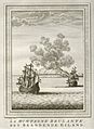
An 18th-century Dutch etching, possibly showing the 1680 eruption of Krakatoa.

See also
 In Spanish: Krakatoa para niños
- Krakatoa documentary and historical materials
- List of volcanic eruptions by death toll
- List of volcanoes in Indonesia
