
Sumatra facts for kids

Topography of Sumatra
|
|

Location of Sumatra within the Indonesian Archipelago
|
|
| Geography | |
|---|---|
| Location | Southeast Asia |
| Coordinates | 00°N 102°E / 0°N 102°E |
| Archipelago | Indonesian Archipelago
Greater Sunda Islands |
| Area | 482,286.55 km2 (186,211.88 sq mi) |
| Highest elevation | 3,805 m (12,484 ft) |
| Highest point | Kerinci |
| Administration | |
| Provinces | Aceh North Sumatra West Sumatra Riau Jambi Bengkulu South Sumatra Lampung |
| Largest settlement | Medan (pop. 2,097,610) |
| Demographics | |
| Population | 60,795,669 (mid 2023 estimate) |
| Pop. density | 126 /km2 (326 /sq mi) |
| Ethnic groups | Acehnese, Batak, Gayonese, Lampung, Malay, Mentawai, Minangkabau, Nias, Palembang, Rejang, Chinese, Indian, Javanese, Sundanese etc. |
| Additional information | |
| Time zone | |
Sumatra is a very large island in western Indonesia. It is part of the Sunda Islands. Sumatra is the biggest island that is completely inside Indonesia. It is also the sixth-largest island in the world. Its total area is about 482,286 square kilometers (182,812 square miles). This includes smaller islands nearby like Simeulue, Nias, and the Mentawai Islands.
Sumatra is long and stretches from northwest to southeast. The Indian Ocean is to its west and southwest. To the northeast, the narrow Strait of Malacca separates it from the Malay Peninsula. To the southeast, the Sunda Strait separates Sumatra from Java. The Bukit Barisan mountains run along the island, and they have many active volcanoes. The eastern part of Sumatra has large flat areas with swamps and forests. The equator line crosses the middle of the island. Sumatra has a hot and humid tropical climate. Long ago, thick tropical rain forests covered most of the island.
Sadly, Sumatra has lost almost half of its rainforests in the last 35 years. Many animals are now critically endangered, meaning they are at high risk of disappearing forever. These include the Sumatran tiger, Sumatran elephant, and Sumatran orangutan. Cutting down forests has also caused smoky haze in nearby countries like Malaysia and Singapore.
Contents
What's in a Name? The Story of Sumatra's Name
Sumatra was known by different names in ancient times. People called it Svarṇadvīpa (meaning 'Island of Gold') and Svarṇabhūmi ('Land of Gold'). This was because of the gold found in its mountains.
The name "Sumatra" was first used in 1017. At that time, a local king named Haji Sumatrabhumi ("king of the land of Sumatra") sent a message to China. Arab travelers from the 10th to 13th centuries called the island Lamri. This name came from a kingdom near what is now Banda Aceh.
Later, in the 13th century, the famous traveler Marco Polo called a kingdom there Samara. Another traveler, Odoric of Pordenone, used the name Sumoltra. By the 14th century, the name "Sumatra" became popular because of the powerful kingdoms of Samudera Pasai and later the Aceh Sultanate. Since then, most European writers have used "Sumatra" for the whole island.
A Look Back: Sumatra's History


The Melayu Kingdom was an important early kingdom in Sumatra. By the year 692, it became part of the powerful Srivijaya kingdom. Srivijaya was a major trading empire, but its power began to fade in the 11th century after a defeat by the Chola Empire from India.
Around the same time, Islam slowly started to spread in Indonesia. Sumatra was one of the first places to welcome Islam. This happened because Sumatra is close to the Strait of Malacca, a very busy trade route. Arab and Tamil traders, who were often Muslim, brought Islam to Sumatra in the 6th and 7th centuries. By the late 13th century, the king of the Samudra kingdom had become Muslim.

In the 16th century, Aceh in northern Sumatra became a very important trading center, especially for pepper. The Aceh Sultanate grew strong and traded with many parts of the world. Its golden age was during the rule of Iskandar Muda, who expanded Aceh's influence. Aceh often competed with other kingdoms and European powers like the Dutch and Portuguese.
Later, the Dutch Empire slowly took control of many parts of Sumatra. However, Aceh fought against the Dutch in a long and difficult war called the Aceh War (1873–1903).
During World War II, Japan invaded Sumatra in 1942. After the war, Indonesia gained independence.
From 1976 to 2005, the Free Aceh Movement fought against the Indonesian government in the Aceh Insurgency.
Sumatra has also faced big natural disasters. The island was greatly affected by the 1883 Krakatoa volcano eruption. It was also hit hard by the huge Boxing Day Tsunami in 2004, which caused a lot of damage, especially in Aceh province.
People of Sumatra: Demographics
| Historical population | ||
|---|---|---|
| Year | Pop. | ±% |
| 1971 | 20,808,148 | — |
| 1980 | 28,016,160 | +34.6% |
| 1990 | 36,506,703 | +30.3% |
| 1995 | 40,830,334 | +11.8% |
| 2000 | 42,616,164 | +4.4% |
| 2005 | 45,839,041 | +7.6% |
| 2010 | 50,613,947 | +10.4% |
| 2015 | 55,198,752 | +9.1% |
| 2020 | 58,557,211 | +6.1% |
| 2023 | 60,795,669 | +3.8% |
| sources: | ||
In 2023, Sumatra's population was estimated to be about 60.8 million people. This makes it the fifth-most populated island in the world. Even though it has many people, Sumatra is a very large island, so it's not as crowded as some other places. On average, there are about 126 people per square kilometer.
-
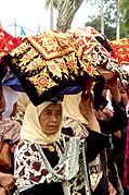
Minangkabau women carrying platters of food to a ceremony
-
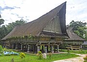
Traditional house in Simalungun North Sumatra

_(01).jpg)
Ethnic Groups: Diverse Cultures of Sumatra
Sumatra is home to many different ethnic groups. The largest groups who have lived on the island for a long time include the Malays, Minangkabaus, Bataks, Acehnese, and Lampungs. Other large groups, like the Javanese, Sundanese, and Chinese, have also settled here.
Here are some of the largest ethnic groups in Sumatra, based on the 2010 census:
| Ethnic groups | Population |
|---|---|
| Javanese | 15,239,275 |
| Indonesian Malays (Riau,Jambi,Palembang,Other Malay Subgroups) | 12,308,609 |
| Bataks | 7,302,330 |
| Minangkabau | 5,799,001 |
| Ethnic groups from Aceh (incl. Acehnese, Gayo, etc.) |
3,991,883 |
| Sundanese | 1,231,888 |
| Ethnic groups from Lampung (incl. Lampung people) |
1,109,601 |
| Nias | 1,021,267 |
| Other | 2,086,804 |
Languages Spoken in Sumatra
More than 52 different languages are spoken in Sumatra! Most of these languages belong to the Austronesian language family. Some examples include Acehnese, Malay, Minangkabau, and various Batak languages.
Like everywhere else in Indonesia, the Indonesian language is the official language. It is also the main language people use to communicate across different ethnic groups. In some areas, local forms of Malay are popular. For example, Medan Malay is spoken in North Sumatra, and Palembang Malay is used in South Sumatra.
Religion in Sumatra
Religion in Sumatra (2023) Islam (87.41%) Protestantism (9.15%) Roman Catholic (1.68%) Buddhism (1.36%) Hinduism (0.32%) Confucianism (0.061%) Folk religion (0.02%)
Most people in Sumatra are Muslims, making up about 87% of the population. About 10.7% are Christians, and smaller numbers follow Buddhism and Hinduism.
Here is a breakdown of religions in Sumatra (2023):
| Religions | Total |
|---|---|
| Islam | 53,409,001 |
| Protestant | 5,592,010 |
| Roman Catholic | 1,023,603 |
| Buddhism | 832,415 |
| Hinduism | 193,917 |
| Confucianism | 37,214 |
| Aliran Kepercayaan | 10,893 |
| Overall | 61,099,053 |
How Sumatra is Governed: Provinces
Sumatra is one of Indonesia's main geographical regions. It includes the main island and many smaller islands nearby. Sumatra is divided into ten provinces. Each province has its own capital city.
Here are the provinces in the Sumatra region, with their areas and populations:
| Name | Map | Area (km2) | Population estimate 2023 |
Capital |
|---|---|---|---|---|
 |
58,485.90 | 5,512,219 | Banda Aceh | |
(Sumatra Utara) |
 |
72,460.74 | 15,386,640 | Medan |
(Sumatra Barat) |
 |
42,119.54 | 5,757,210 | Padang |
 |
89,935.90 | 6,642,874 | Pekanbaru | |
(Kepulauan Riau) |
 |
8,269.71 | 2,162,140 | Tanjung Pinang |
 |
49,026.58 | 3,679,169 | Jambi | |
(Sumatra Selatan) |
 |
91,592.43 | 8,743,522 | Palembang |
 |
20,130.21 | 2,086,006 | Bengkulu | |
 |
33,575.41 | 9,313,990 | Bandar Lampung | |
(Kepulauan Bangka Belitung) |
 |
16,690.13 | 1,511,899 | Pangkal Pinang |
| Totals | 482,286.55 | 60,795,669 |
Sumatra's Landscape: Geography


Sumatra is about 1,790 kilometers (1,112 miles) long from northwest to southeast. At its widest point, it is about 435 kilometers (270 miles) across. The island's middle part is divided into two main areas: the Barisan Mountains in the west and flat, swampy plains in the east. Sumatra is the closest Indonesian island to mainland Asia.
To the southeast, the Sunda Strait separates Sumatra from Java. To the north, the Strait of Malacca separates it from the Malay Peninsula. To the east, Borneo is across the Karimata Strait. The Indian Ocean lies to the west of Sumatra.
Sumatra is located on a very active fault line called the Great Sumatran fault. There is also a subduction zone called the Sunda megathrust along its west coast. This means earthquakes are very common here. On December 26, 2004, a huge earthquake caused a massive tsunami that hit Sumatra's western coast, especially Aceh province. More than 170,000 people in Indonesia died. Other big earthquakes have also struck Sumatra, like the 2005 Nias–Simeulue earthquake and the 2010 Mentawai earthquake and tsunami.
Lake Toba in Sumatra is actually a huge lake inside a supervolcano crater. A massive eruption happened there about 74,000 years ago, which changed the climate around the world.
Many important rivers flow from Sumatra's mountains into the South China Sea. These rivers carry soil and create large lowlands with swamps in the east. These areas are important for Indonesia's economy because they produce palm oil and petroleum. Sumatra is also the biggest producer of Indonesian coffee.
Big Cities in Sumatra
.jpg)
Medan is the largest and most developed city in Sumatra. It is also the most visited.
Here are some of the largest cities in Sumatra by population:
| Rank | City | Province | Population 2020 census |
|---|---|---|---|
| 1 | Medan | North Sumatra | 2,435,252 |
| 2 | Palembang | South Sumatra | 1,668,848 |
| 3 | Bandar Lampung | Lampung | 1,166,066 |
| 4 | Pekanbaru | Riau | 983,356 |
| 5 | Padang | West Sumatra | 909,040 |
| 6 | Jambi | Jambi | 606,200 |
| 7 | Bengkulu | Bengkulu | 373,591 |
| 8 | Dumai | Riau | 316,782 |
| 9 | Binjai | North Sumatra | 291,842 |
| 10 | Pematang Siantar | North Sumatra | 268,254 |
| 11 | Banda Aceh | Aceh | 252,899 |
| 12 | Lubuklinggau | South Sumatra | 234,166 |
Amazing Nature: Flora and Fauna


Sumatra has many different types of plants and animals. It is home to unique plants like the Sumatran pine in the mountains. It also has famous rainforest plants such as the Rafflesia arnoldii, which has the world's largest single flower, and the titan arum, known for its very large flower cluster.
The island is home to 201 kinds of mammals and 580 kinds of birds. There are also about 300 types of freshwater fish. Many animals are found only in Sumatra or its nearby islands.
Sadly, many of Sumatra's animals are now critically endangered. This means they are at very high risk of disappearing forever. These include the Sumatran tiger, Sumatran rhinoceros, Sumatran elephant, and Sumatran orangutan. In 2008, the Indonesian government announced a plan to protect Sumatra's remaining forests to help save these animals.
Sumatra has more than 10 national parks. Three of these parks – Gunung Leuser National Park, Kerinci Seblat National Park, and Bukit Barisan Selatan National Park – are so important that they are listed as a World Heritage Site by UNESCO. These parks help protect the island's amazing rainforests and wildlife.
Getting Around: Rail Transport
Sumatra has several railway networks that were built a long time ago when the Netherlands East Indies ruled. These railways connect different parts of the island. For example, there are lines in North Sumatra connecting cities like Medan and Pematang Siantar. There are also lines in West Sumatra and South Sumatra, connecting cities like Padang and Palembang. Some older sections of the railway are being rebuilt to improve travel across the island.
See also
 In Spanish: Sumatra para niños
