
Riau Islands facts for kids
Quick facts for kids
Riau Islands
Kepulauan Riau
|
|||
|---|---|---|---|
| Regional transcription(s) | |||
| • Jawi | كڤولاوان رياو | ||
     From top, left to right : Barelang Bridge, Scenery at Serasan Harbor in the Natuna Islands, Palmatak Island in the Anambas Islands, A view from Nyamuk in Siantan Timur, Beach in Bintan Island, Panoramic view of Batam Center Harbour
|
|||
|
|||
| Motto(s): | |||
.svg)
Location of Riau Islands in Indonesia
|
|||
| Country | |||
| Established | September 24, 2002 | ||
| Capital | Tanjung Pinang | ||
| Largest city | Batam | ||
| Area | |||
| • Total | 10,595.41 km2 (4,090.91 sq mi) | ||
| Area rank | 31st | ||
| Elevation | 2-5 m (−14.4 ft) | ||
| Highest elevation | 1,165 m (3,822 ft) | ||
| Lowest elevation | 0 m (0 ft) | ||
| Population
(2017)
|
|||
| • Total | 2,028,169 | ||
| • Rank | 27th | ||
| • Density | 191.41959/km2 (495.7745/sq mi) | ||
| • Density rank | 10th | ||
| Demonym(s) | Riau Islander Warga Kepulauan Riau (id) Kaum Kepulauan Riau (ms) |
||
| Demographics | |||
| • Ethnic groups | Malays (35.6%) Javanese (18.2%) Chinese (14.3%) Minangkabau (9.3%) Batak (8.1%) Buginese (2.2%) Banjarese (0.7%) |
||
| • Religion | Islam (77.51%) Protestantism (12.22%) Buddhist (7.57%) Roman Catholicism (2.46%) Confucianism (0.17%) Hinduism (0.05%) Others (0.02%) |
||
| • Languages | Indonesian (official) Malay (regional) Other languages: Javanese, Minangkabau, Batak, Buginese, Banjarese, Riau Hokkien, Hakka, Teochew, Yue, Mandarin, Tamil |
||
| Time zone | UTC+7 (Indonesia Western Time) | ||
| Postcodes |
29xxx
|
||
| Area codes | (62)77x | ||
| ISO 3166 code | ID-KR | ||
| Vehicle sign | BP | ||
| GRP per capita | $8,036 | ||
| HDI | |||
| HDI rank | 4th (2018) | ||


The Riau Islands (Indonesian: Kepulauan Riau) is a province in Indonesia. It has 1,796 islands located between important sea routes. These include the Strait of Malacca, the Karimata Strait, and the South China Sea. This makes the province a busy place for ships.
The Riau Islands share water borders with Singapore, Malaysia, and Vietnam. It used to be part of the Riau province. In September 2002, it became Indonesia's 32nd province. The capital city is Tanjung Pinang, and the largest city is Batam.
The first people living here were called Orang Laut. They were important for many Malay kingdoms, like Srivijaya and the Johor Sultanate. They helped control trade routes through the Malacca Strait. After the fall of Malacca in 1511, the Riau Islands became a powerful center for the Sultanate of Johor-Riau. This sultanate was based on Bintan Island. For a long time, the Riau Islands were seen as the heart of Malay culture.
Contents
What's in a Name?
The name Riau Islands comes from the word Riau. This word might come from riuh, which means "loud" or "noisy" in Malay. This is because the Riau Islands area was once a busy trading spot. Later, the name Riau was used for the Sultanate of Lingga. During the time of colonial rule, the name Riau was spelled Riouw.
Exploring the Riau Islands
Where are the Riau Islands?
The island of Batam is in the middle of the Riau Archipelago. It has most of the province's people. Since 2006, Batam has been part of an economic zone with Singapore. This has made its population grow very quickly.
Other islands with many people include Bintan and Karimun. The province has about 3,200 islands in total. The capital, Tanjung Pinang, is on the south side of Bintan Island.
The Riau Islands province also includes the Lingga Islands to the south. To the northeast is the Tudjuh Archipelago. This group includes the Anambas Islands, Natuna Islands, Tambelan islands, and Badas Islands. These islands were added to the new province.
The Riau Islands Province was created in 2002. It has 5 districts and 2 cities. There are 42 subdistricts and 256 villages. Out of 2,408 islands, 40% are not named or lived on. The total area is 252,601 square kilometers. About 95% of this is ocean, and only 5% is land.
The Riau Islands are in a very important location. They are between the South China Sea, the Strait of Malacca, and the Karimata Strait. This location and its natural resources can help Indonesia's economy grow. Some areas like Batam, Bintan, and Karimun are special economic zones. They work with Singapore to boost trade and business.
These special economic zones aim to be top centers for business. They offer excellent services and modern facilities. Businesses there get high-quality support. This helps them compete with other areas in Asia-Pacific.
What is the Climate Like?
The Riau Islands have a wet tropical climate. This means they have a rainy season and a dry season. The average temperature is around 20.4 °C.
From November to February, monsoon winds come from the north. From June to December, they come from the south. During the northern monsoon, winds at sea can be strong. This can cause rough weather. Rainfall can be about 150-200 millimeters, and waves can be 1.2 to 3 meters high.
A Look at History

From ancient times until the 16th century, Riau was a key part of Malay kingdoms. It was in the heart of what is called the Malay World. This area stretched from Sumatra to Borneo. The Orang Laut people lived on the islands. They helped Malay kingdoms control trade routes through the Strait of Malacca.
After the fall of Malacca in 1511, the Riau Islands became the center of power. This was for the strong Sultanate of Johor or Johor-Riau. It was based on Bintan Island. The Riau Islands were long seen as the center of Malay culture.
But history changed when European powers wanted to control trade routes. They used weaknesses within the sultanate. Singapore island, which was part of the Malay kingdoms, came under British control.
The Anglo-Dutch Treaty of 1824 divided the region. The British controlled lands north of the Singapore Strait. The Dutch controlled lands from Riau to Java.
After the Europeans left, new independent governments formed. They had to reorganize after 100 years of colonial borders. The areas of Indonesia, Malaysia, Singapore, Brunei, and Borneo faced conflicts. The Riau Islands were again in the middle of a regional struggle.
The strong cultural unity of the Riau region did not fully return. The line drawn by the British in 1819 stayed. It divided the area into three new countries in 1965: Singapore, Malaysia, and Indonesia.
Some unity returned with the Sijori Growth Triangle in 1989. This brought economic growth to Riau. However, it also changed the cultural mix on the islands. Batam island received many investments. It grew into a big industrial center. This attracted many non-Malay Indonesian people. This changed the population balance in the islands forever.
However, this change also made Batam more diverse. It now has many cultures. This can lead to better economic and educational growth in the future. Batam has become a busy industrial island with a growing tourism sector.
How the Riau Islands are Governed
The Riau Islands province is divided into five regencies and two cities. Here are their populations from the 2010 Census:
| Name | Area (km2) | Population Census 2000 |
Population Census 2010 |
Population Est 2014 |
Capital | Notes | HDI 2018 Estimates |
|---|---|---|---|---|---|---|---|
| Batam City | 960.25 | 455,103 | 944,285 | 1,142,646 | Batam | includes Bulan, Galang and Rempang islands, as well as all of Batam Island |
0.805 (Very High) |
| Tanjung Pinang City | 144.56 | 142,929 | 187,359 | 226,716 | Tanjung Pinang | on Bintan Island | 0.783 (High) |
| Anambas Islands Regency (Kepulauan Anambas) |
590.14 | 28,510 | 37,411 | 45,270 | Tarempa | 0.675 (Medium) | |
| Bintan Regency | 1,318.21 | 110,068 | 142,300 | 172,192 | Bandar Seri Bentan | 0.734 (High) | |
| Karimun Regency | 912.75 | 171,405 | 212,561 | 257,212 | Tanjung Balai | including Karimun and Kundur Islands | 0.705 (High) |
| Lingga Regency | 2,266.77 | 79,451 | 86,244 | 104,361 | Daik | covering the Lingga Islands | 0.640 (Medium) |
| Natuna Regency | 2,009.04 | 52,741 | 69,003 | 83,498 | Ranai | 0.721 (High) |
Economy and Tourism
What is the Economy Like?
The Riau Islands province is mostly ocean, about 96% of its area. This is great for developing fishing and fish farming. Many areas in the province have fertile soil. This means they can be used for farming.
The farming sector is very important, especially in Bintan, Karimun, and Batam. Besides regular crops, things like coconuts, coffee, pineapples, and cloves grow well. Bintan and Lingga are good for growing fruits and vegetables. Some islands are also good for oil palm plantations.
What are the Tourist Attractions?
Tourism is a major part of the Riau Islands' economy. The province has beautiful nature, art, and culture. It has a tropical climate and 2,408 islands. About 30% of these islands are not lived on.
The Lower Island of Anambas Islands was named one of Asia's best tropical islands by CNN. Sisi Beach in Natuna was also called one of the world's best natural beaches by Island magazine in 2006. Penyengat Island and Bintan Island are also popular places to visit.
People and Culture
Religion in Riau Islands
| Religion in Riau Islands (2017) | ||||
|---|---|---|---|---|
| religion | percent | |||
| Islam | 77.51% | |||
| Protestantism | 12.22% | |||
| Buddhism | 7.57% | |||
| Roman Catholicism | 2.46% | |||
| Confucianism | 0.17% | |||
| Hinduism | 0.05% | |||
| Others | 0.02% | |||
Islam is the main religion in the Riau Islands. About 77.51% of the people are Muslim. Other religions include Christianity (14.68%), Buddhism (7.51%), Hinduism (0.05%), and Confucianism (0.17%).
Who are the Ethnic Groups?

The main ethnic group in the province is Malay, making up 35.6% of the population. The region is considered part of the Malay world. A group within the Malays are called Orang Laut.
Orang Laut have a rich culture connected to the sea. They used to live in boats. Today, many Orang Laut have settled on land. The term Orang Laut includes different tribes and groups. These groups settled on the islands and rivers of Riau-Lingga, Tujuh Island, Batam Island, and the coasts of eastern Sumatra and the Malay Peninsula.
Orang Laut traditionally lived in canoes or boat houses. They mainly fished and looked for sea animals like sea cucumbers. Other ethnic groups in the Riau Islands are mostly people who moved there from other parts of Indonesia.
What Languages are Spoken?
The language of the Riau Islands is known as Riau Malay. The Riau Islands are thought to be where the modern Malay language began. However, the formal Malay used in the Johor court became the basis for the standard language.
Besides Riau Malay, other types of Malay are spoken. In the Anambas Islands and Natuna Islands, people speak a Malay that is similar to what is spoken on the eastern coast of Peninsular Malaysia. Other languages spoken include Javanese, Sundanese, Batak, and different kinds of Chinese. These include Hokkien, Hakka, Teochew, and Cantonese.
Getting Around the Islands
Sea Transportation

Since the Riau Islands are made up of many islands, water transport is the main way to travel. Ferries, boats, canoes, speedboats, and other ships connect the islands. These ships are owned by companies like Pelni and private businesses.
The main ports are in Batam, Bintan, and Tanjungpinang. These ports include Sri Bintan Pura, Bulang Linggi, Nongsa, Telaga Punggur, Sekupang, and Batam Center. From these ports, you can travel to other cities in the Riau Islands, Sumatra, Java, Kalimantan, and Sulawesi. You can also travel to other countries like Malaysia, Singapore, Japan, South Korea, and more.
Air Transportation
.jpg)
Air transport is the second most important way to travel. Sometimes, bad weather and strong waves make people choose flying. This is especially true for people in Anambas and Natuna Islands. Six out of seven districts and cities in the Riau Islands have an airport.
The Riau Islands have two international airports. These are Hang Nadim Airport in Batam and Raja Haji Fisabilillah International Airport in Tanjungpinang. Both airports have flights to Malaysia, Singapore, China, and Russia. There are also domestic airports like Ranai Airport and Dabo Airport. These connect to other cities in Indonesia. New airports are also being built.
Delicious Riau Islands Food

The food in the Riau Islands is often similar to food in Peninsular Malaysia. This is because they share a similar culture. Some dishes are also influenced by other parts of Indonesia, like Java. Because of its many cultures, the Riau Islands have unique dishes.
- Mie Tarempa - This dish is made from yellow noodles, eggs, sprouts, and pieces of sea fish. It is fried with chili spices. You can easily find it in the Anambas Islands and nearby areas.
- Laksa - Laksa, or Lakse in the local language, is a noodle dish. It mixes Chinese and Malay spices. Lakse noodles are round, white, and a bit thick. The name "lakse" comes from a Sanskrit word meaning "many." This shows it is made with many spices. In the Riau Islands, there are different kinds of lakse. Anambas lakse is a curry-style dish with a rich, spicy sauce.
- Sup Ikan Batam - This is a famous mackerel fish soup from Batam. It is called Batam Fish Soup in Indonesian. The soup has slices of mackerel fish without bones. The fish is coated with egg whites to remove any fishy smell. It is cooked with spices, starfruit, and green tomatoes. White or green mustard greens are also added.
- Nasi Lemak - Nasi Lemak is rice cooked in coconut milk and spices like ginger. Sometimes, lemongrass is added for more flavor. It is served with side dishes, often including chili fish or crackers.
- Mie Lendir - This dish has yellow noodles boiled with sprouts. It is eaten with a boiled egg cut in half. A thick peanut sauce is poured over the noodles. The thick sauce is why it is called Mie Lendir ("Slime Noodles"). Mie Lendir is often eaten for breakfast.
- Bak kut teh - This is a Chinese-influenced dish found in the Riau Islands, Singapore, and Malaysia. "Bak kut teh" means "meat tea bone." "Bak kut" refers to pork ribs. The word "teh" (tea in Hokkien) might come from the dish's brown sauce, which looks like tea. Or, it might be because it was first served with tea. The gravy is a pork broth with garlic and strong pepper.
- Teh Tarik - Teh Tarik is tea mixed with sweet milk. The foam on top is made by pouring the tea from one glass to another. Teh Tarik is usually served with nasi lemak.
- Lempok durian - This is a special sweet treat from Anambas. It tastes better than similar treats from Sumatra or Kalimantan. It is made from durian fruit and sugar. You can buy it at restaurants and food stalls in Tarempa or Letung.
- Gonggong - This dish is named after the Chinese water god Gonggong. It is the main specialty of the province. This seafood is usually boiled and eaten with a special sauce. In Kepri, these sea animals are found in the waters of Lobam, Tanjung Uban, Bintan, and Batam. Gonggong is very nutritious. Some people believe it helps with growth and energy.
- Kue Deram-Deram - This is a traditional Malay cake found in Tanjung Pinang, especially on Penyengat Island. It looks like a donut with a hole in the middle. But it is smaller and has a different taste.
- Lendot - Lendot is a traditional Malay food. It tastes savory and a little spicy. Lendot is made from sago flour, spices, and kangkung (water spinach). It can also have snails, shrimp, squid, or other seafood. Lendot is usually eaten hot or warm.
Images for kids
-
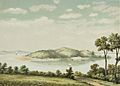
Pulau Penyengat (Lit: Wasp island), lithography of an original watercolour by J.C. Rappard. ca. 1883–1889.
-
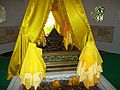
The Tomb of Puteri Hamidah, Queen of Sultan Mahmud Shah III.
-
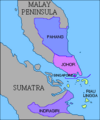
Anglo-Dutch Treaty of 1824
-
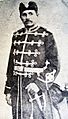
Ali Kelana, Crown Prince of Riau-Lingga, one of the founding fathers of the Roesidijah Club Riouw, the first modern organisation in the Netherlands East Indies. (taken in 1899)
-
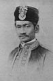
Abdul Rahman II of Riau Lingga, the last sultan of Riau-Lingga sultanate. He was subsequently deposed by the Dutch and went into exile
-
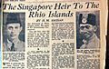
An article by H. M. Hassan entitled "The Singapore heir to the Rhio Islands" published in The Straits Times.
-
In the 1970s, the city of Batam started an industrial boom, which continues to this day
-
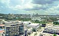
Tanjung Piayu, a scenic area in Batam
-
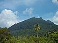
Tropical vegetation on Mount Ranai in eastern Great Natuna Island
-
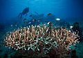
Coral Reef at Anambas
-
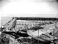
Tin mining in Singkep, Lingga Islands
-
PLTU Batam
-
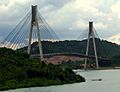
The cable-stayed Tengku Fisabilillah Bridge connecting Batam and Tonton, a part of the Barelang Bridge
-
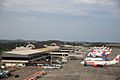
Hang Nadim International Airport in Batam, the busiest airport in the province
-
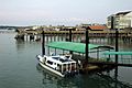
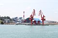
Tanjung Pinang Ferry Harbor
-
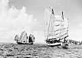
Chinese junks Sin Tong Heng and Tek Hwa Seng in the Sambu Island, Singapore Strait, c. 1936. The Chinese has inhabited the Riau Islands since the late 18th century
-
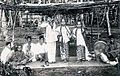
A troupe of local Riau Malay dancers performing the Joget Lambak. (taken in the late 19th century)
-
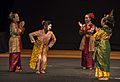
Mak Yong dancers in Bintan
-
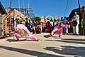
Malay men performing the Silat Pengantin traditional dance in a wedding ceremony at Lingga Islands
-
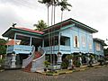
A typical Malay traditional house in the Taman Mini Indonesia Indah, Jakarta
-

Nasi lemak Sambal Cumi, a variety of Nasi Lemak that can be found in the Riau Islands
-
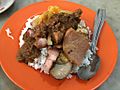
Nasi Campur, commonly consumed by the Chinese community in the Riau Islands
-
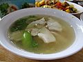
Sop Ikan Batam (Batam Fish Soup), a dish native to the city of Batam
-
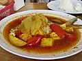
Sop Asam Pedas, a Malay-Minangkabau dish
-
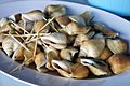
Siput Gongong, a common dish in Batam made of Laevistrombus canarium


.jpg)


_en_Tek_Hwa_Seng_bij_Poeloe_Samboe_TMnr_10010680.jpg)


See also
 In Spanish: Provincia de las Islas Riau para niños
