Singapore Strait facts for kids
Quick facts for kids Singapore Strait |
|
|---|---|

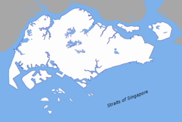
Map of the Singapore Strait
|
|
| Coordinates | 1°13′N 103°55′E / 1.217°N 103.917°E |
| Type | strait |
| Basin countries | Singapore Malaysia Indonesia |
| Max. length | 105 km (65 mi) |
| Min. width | 16 km (9.9 mi) |
| Average depth | 22 metres (72 ft) (minimum, within the nautical channel) |
| Settlements | Singapore Batam |

The Singapore Strait is a busy waterway located in Southeast Asia. It is a narrow passage of water that connects the Strait of Malacca in the west to the Karimata Strait in the east. This strait is about 105 kilometers (65 miles) long and 16 kilometers (10 miles) wide.
To the north of the strait is the country of Singapore. To the south are the Riau Islands of Indonesia. The border between Indonesia and Singapore runs right through the middle of this strait.
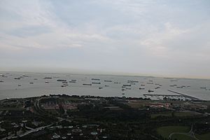
The Singapore Strait includes areas like Keppel Harbour and many small islands. It is very important because it provides a deep path for ships to reach the Port of Singapore. This makes it one of the busiest waterways in the world. Around 2,000 merchant ships travel through these waters every single day! The depth of the strait also affects how large ships can be when they pass through the wider Straits of Malacca.
Contents
A Look Back in Time
People have known about the Singapore Strait for a very long time. An author from the 9th century, Ya'qubi, wrote about a "Sea of Salahit." This name likely came from the Malay word selat, which means strait. Some people think he was talking about the Singapore Strait. Others believe he meant the Strait of Malacca.
Early European travelers to Southeast Asia also used the term "Strait of Singapore." Sometimes, they used it to mean the entire southern part of the Strait of Malacca. Other times, they used it for different stretches of water.
Historians also used the term "Singapore Straits" (plural) to describe several different passages. These included the Old Strait of Singapore, the New Strait of Singapore, and others. Today, when we say "Singapore Strait," we mean the main waterway south of Singapore. This is where the international border between Singapore and Indonesia is located.
World War II History
During the Second World War, the British military placed underwater mines in the strait. This was done to protect the area during the conflict.
Understanding the Strait's Borders
The International Hydrographic Organization is a group that defines the limits of oceans and seas. They have set clear boundaries for the Singapore Strait.
- To the West: The strait starts where the Malacca Strait ends. This is marked by a line connecting Tanjong Piai in Malaysia to The Brothers islands and then to Klein Karimoen island.
- To the East: The strait ends with a line connecting Tanjong Datok in Johor, Malaysia, through Horsburgh Reef, to Pulo Koko on Bintan Island.
- To the North: The northern edge follows the southern coast of Singapore Island, Johore Shoal, and the southeastern coast of the Malay Peninsula.
- To the South: The southern edge goes from Klein Karimoen to Pulo Pemping Besar. It then follows the northern coasts of Batam and Bintan Islands until Pulo Koko.
Maps and Guides
Because the Singapore Strait is so important for shipping, special maps and guides have been made for a long time. These guides help ships navigate safely through the busy waters.
See also
 In Spanish: Estrecho de Singapur para niños
 | William Lucy |
 | Charles Hayes |
 | Cleveland Robinson |


