
Tsunami facts for kids


A tsunami is a series of very powerful ocean waves. They are usually caused by big events like earthquakes under the sea, volcanic eruptions, or large landslides. Sometimes, even a meteor crashing into the ocean can cause one!
The word "tsunami" comes from Japanese. It means "harbour wave." This is because fishermen might be out at sea and not notice a tsunami. But when they return, their harbour could be destroyed.
Tsunamis have very long wavelengths, sometimes hundreds of kilometres long. They travel very fast across the ocean, losing little energy. When they hit land, they can wash away sand from beaches. They can also destroy trees, drag vehicles, and even flatten houses or whole towns. Most tsunamis happen in the Pacific Ocean, especially in the area called the Ring of Fire. However, they can happen in any large body of water.
Before a tsunami hits, the ocean water often pulls back from the shore. This can happen for hundreds of meters if the coast is flat. People who do not know about the danger might stay on the shore.
We cannot stop tsunamis from happening. But we can help prevent people from dying. Warning systems, especially for the Pacific Ocean, send out alerts. These warnings give people time to get to safety before the big waves arrive.
Tsunamis are sometimes called tidal waves. This is because they rise and fall more slowly than normal ocean surface waves. But this name is misleading. Tsunamis are not related to tides at all.
The deadliest tsunami ever recorded happened on December 26, 2004. It is known as the 2004 Indian Ocean Tsunami. An earthquake with a magnitude of 9.3 caused it. The earthquake happened near the coast of Sumatra, Indonesia. Over 215,000 people died, mostly around the Indian Ocean. This giant wave moved very quickly. It killed or injured thousands in Indonesia, Sri Lanka, Thailand, India, and Somalia.
The 2011 Tōhoku earthquake and tsunami was the most expensive tsunami. It cost the Japanese government about $150 billion. This tsunami traveled far inland. It is also the fourth largest tsunami in history.
There is also a megatsunami. This is a very rare and huge tsunami. It is usually caused by something big hitting the ocean, like an asteroid or a massive landslide.
Contents
History of Tsunamis

Japan has the longest recorded history of tsunamis. The Sumatran region also often experiences tsunamis. Earthquakes happen regularly off the coast of this island.
The Mediterranean Sea and parts of Europe have also had tsunamis. Important ones include the 1755 Lisbon earthquake and tsunami. This event caused tens of thousands of deaths. The 1908 Messina earthquake and tsunami also killed over 123,000 people. It is one of the deadliest natural disasters in modern Europe.
The ancient Greek historian Thucydides wrote about tsunamis in 426 BC. In his book History of the Peloponnesian War, he was the first to say that ocean earthquakes cause them. The oldest record of a tsunami by humans is from 479 BC. It happened in the Greek colony of Potidaea. An earthquake likely caused it. This tsunami may have saved the colony from an invasion.
The Roman historian Ammianus Marcellinus described a tsunami in 365 AD. He wrote about the 365 AD tsunami that destroyed Alexandria. He noted the earthquake, the sea pulling back, and then a giant wave.
What Causes Tsunamis?
The main way a tsunami starts is when a large amount of water in the sea is suddenly moved. This usually happens because of earthquakes. But it can also be caused by landslides, volcanic eruptions, or ice breaking off glaciers. Very rarely, meteorites or nuclear tests can also cause them.
Earthquakes Under the Sea
Tsunamis can be created by an earthquake that happens under the sea. When the seafloor moves, the water above it is pushed away from its normal position.
-
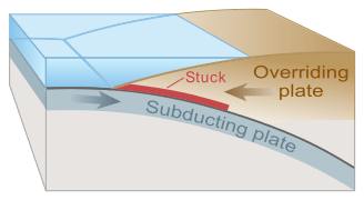
Drawing of tectonic plate boundary before earthquake.
-
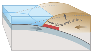
The top plate bulges under pressure, causing the land to lift.
-
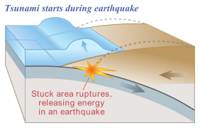
The plate slips, causing the land to drop and releasing energy into the water.
-
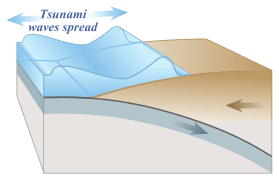
The released energy creates tsunami waves.


In the deep ocean, tsunamis have a small wave height. They also have a very long wavelength, often hundreds of kilometres long. Normal ocean waves are only about 30 or 40 meters long. This is why tsunamis are hard to notice at sea. They look like a slight swell, only about 300 mm (12 inches) above the normal sea surface. A tsunami can happen at any tide level. Even at low tide, it can still flood coastal areas.
Powerful earthquakes can cause tsunamis that cross entire oceans. These are called teletsunamis. Examples include the 1960 Valdivia earthquake and the 2004 Indian Ocean earthquake. Smaller earthquakes in Japan can also trigger tsunamis. These local tsunamis can devastate coastlines in just a few minutes.
Landslides Causing Tsunamis
In the 1950s, scientists found that huge submarine landslides can cause very large tsunamis. These landslides move a lot of water very quickly. This transfers energy faster than the water can absorb it. In 1958, a giant landslide in Lituya Bay, Alaska, caused the highest wave ever recorded. It was 524 meters (1,720 feet) tall! This wave did not travel far because it hit land almost right away. It sank two boats, killing two people.
Another landslide tsunami happened in 1963 in Italy. A huge landslide from Monte Toc fell into the reservoir behind the Vajont Dam. The wave went 250 meters (820 feet) over the 262-meter (860-foot) high dam. It destroyed several towns and killed about 2,000 people. Scientists call these waves megatsunamis.
Some geologists think that large landslides from volcanic islands could create megatsunamis that cross oceans. But many others disagree.
Volcanic Eruptions and Tsunamis
Volcanic eruptions can also trigger tsunamis. Famous examples include the 1883 eruption of Krakatoa. More recently, the 2022 Hunga Tonga–Hunga Ha'apai eruption also caused a tsunami.
We understand volcanic tsunamis less than those caused by earthquakes. This makes it harder to be ready for them.
Weather-Related Tsunamis
Some weather conditions can also move bodies of water enough to cause waves. These are called meteotsunamis. They are usually less powerful than seismic tsunamis. However, they can still cause local damage and even loss of life. They have been seen in places like the Great Lakes and the English Channel.
Meteotsunamis are different from storm surges. Storm surges are local rises in sea level caused by strong winds from storms. They do not travel like tsunami waves.
Human-Made Tsunamis
There have been studies about creating tsunami waves using explosives. During World War II, New Zealand tried to make small tsunamis with explosives. This attempt failed.
People have also wondered if nuclear weapons could cause tsunamis. Nuclear tests in the Pacific Ocean did not create large, ocean-wide tsunami waves. Most of the energy from these explosions creates steam and vertical fountains of water. Tsunamis need a huge, permanent vertical movement of a large amount of water, which explosions do not cause.
How Tsunamis Behave


Tsunamis cause damage in two ways. First, there is the smashing force of a wall of water moving at high speed. Second, a large amount of water drains off the land, carrying a lot of debris with it. Even waves that do not look huge can be very destructive.
Normal wind waves are about 100 meters (330 feet) long and 2 meters (6.6 feet) high. But a tsunami in the deep ocean is much longer, up to 200 kilometres (120 miles). Such a wave travels over 800 kilometres per hour (500 mph). Because of its huge wavelength, the wave takes 20 or 30 minutes to complete one cycle. Its height is only about 1 meter (3.3 feet). This makes tsunamis hard to spot in deep water. Ships cannot feel them pass.
The speed of a tsunami can be calculated using a formula. For example, in the Pacific Ocean, which is about 5000 meters deep, a tsunami would travel about 806 kilometres per hour (501 mph). Even the deep ocean is considered "shallow" for a tsunami because the wave itself is so long.
As a tsunami gets close to the coast, the water becomes shallow. The wave slows down to less than 80 kilometres per hour (50 mph). Its wavelength shrinks, and its height grows a lot. Since the wave still has the same long time period, it can take minutes to reach its full height. Most tsunamis do not break like normal waves. Instead, they look like a fast-moving tide.
When the tsunami's peak reaches the shore, the temporary rise in sea level is called run up. Run up is measured in meters above the normal sea level. A large tsunami can have several waves arriving over hours. The first wave might not be the highest.
About 80% of tsunamis happen in the Pacific Ocean. But they can happen anywhere there are large bodies of water, even lakes. How a tsunami interacts with the shore is very complex. This makes some countries more at risk than others. For example, Japan has had over a hundred tsunamis in recorded history. But the nearby island of Taiwan has only recorded two.
The Sea Pulls Back (Drawback)

All waves have a high point (crest) and a low point (trough). For a tsunami, either the crest or the trough can arrive first. If the crest arrives first, you will see a huge breaking wave or sudden flooding. But if the trough arrives first, the sea will pull back dramatically. This exposes areas that are usually underwater. This "drawback" can go back hundreds of meters. People who do not know the danger sometimes stay near the shore out of curiosity. They might even try to collect fish from the exposed seabed.
A typical tsunami wave takes about twelve minutes to complete a cycle. So, if the sea pulls back, areas well below sea level are exposed after three minutes. For the next six minutes, the wave builds into a crest that can flood the coast. Destruction then happens. For the next six minutes, the wave changes back to a trough. The floodwaters recede in a second drawback. People and debris can be swept into the ocean. This process repeats with more waves.
Tsunami Heights

Here are some terms used to describe how high a tsunami is:
- Wave Height: This is the height of a tsunami compared to the normal sea level. It is different from the crest-to-trough height used for other waves.
- Run-up Height: This is the highest point the tsunami reaches on land, measured above sea level. The maximum run-up height is often reported as the tsunami's highest point.
- Flow Depth: This is the height of the tsunami water above the ground, no matter how high that ground is.
- Maximum Water Level: This is the highest point the water reaches above sea level, seen from a mark left by the water.
Warnings and Predictions

The sea pulling back (drawback) can be a short warning. People who see the sea pull back should immediately run to high ground. They can also go to the upper floors of nearby buildings. Many survivors say they heard a sucking sound when the sea pulled back.
In 2004, ten-year-old Tilly Smith from England was on a beach in Phuket, Thailand. She had just learned about tsunamis in school. She told her family that a tsunami might be coming. Her parents warned others minutes before the wave arrived. This saved dozens of lives. She gave credit to her geography teacher.
A tsunami cannot be predicted exactly, even if we know where and how big an earthquake was. Scientists study each earthquake. Based on many factors, they decide whether to issue a tsunami warning. However, there are some warning signs. Automated systems can also give warnings right after an earthquake to save lives. One successful system uses sensors at the bottom of the ocean. These sensors are attached to buoys and constantly check the water pressure above them.
Areas with a high tsunami risk often use tsunami warning systems. These systems warn people before the wave reaches land. On the west coast of the United States, warning signs show evacuation routes. In Japan, people are well-educated about earthquakes and tsunamis. Along Japanese coastlines, tsunami warning signs remind people of the dangers. There is also a network of warning sirens.
The Pacific Tsunami Warning Center is in Honolulu, Hawaiʻi. It watches for earthquakes in the Pacific Ocean. If an earthquake is big enough, it triggers a tsunami warning. Not all earthquakes cause tsunamis. Computers help analyze the tsunami risk of every earthquake in the Pacific Ocean.
-
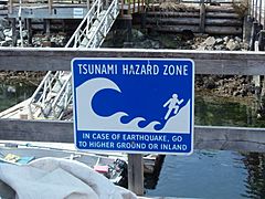
Tsunami hazard sign at Bamfield, British Columbia.
-
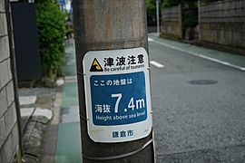
A tsunami warning sign in Kamakura, Japan.
-
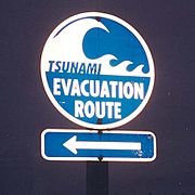
Tsunami Evacuation Route signage along U.S. Route 101, in Washington.


After the 2004 Indian Ocean tsunami, many governments and the United Nations looked again at tsunami threats. A tsunami warning system is now being installed in the Indian Ocean.

Computer models can predict when a tsunami will arrive, usually within minutes. Sensors at the bottom of the ocean send information in real time. Using this information and details about the seafloor and coast, models estimate the tsunami's height. All countries around the Pacific Rim work together in the Tsunami Warning System. Most practice evacuations regularly. In Japan, this preparation is required for everyone.
On the United States west coast, warnings are sent on television and radio.
Do Animals React to Tsunamis?
Some scientists think that certain animals can feel the low-frequency waves from an earthquake or tsunami. If this is true, watching their behavior could give an early warning. However, this idea is still debated. There are stories from the Lisbon quake that some animals escaped to higher ground. Many other animals in the same areas drowned. This was also noted in Sri Lanka during the 2004 Indian Ocean earthquake. It is possible that animals like elephants heard the tsunami approaching. The elephants moved away from the noise. But some humans went to the shore to investigate and drowned.
Reducing Tsunami Damage

In some countries prone to tsunamis, special engineering has been done to reduce damage on land.
Japan has a long history with tsunamis. After a disaster in 1896, Japan started developing ways to protect itself. The country has built many tsunami walls up to 12 meters (39 feet) high. These walls protect coastal areas. Other places have built floodgates up to 15.5 meters (51 feet) high. They also have channels to redirect tsunami water. However, these barriers are not always effective. Tsunamis often go over them.
The Fukushima Daiichi nuclear disaster was caused by the 2011 Tōhoku earthquake and tsunami. The waves were taller than the plant's sea wall. Iwate Prefecture, a high-risk area, had tsunami barrier walls totaling 25 kilometres (16 miles) long. The 2011 tsunami knocked down over 50% of these walls. It caused huge damage.
The Okushiri, Hokkaidō tsunami hit just two to five minutes after the earthquake on July 12, 1993. It created waves 30 meters (98 feet) tall. That is as high as a 10-story building! The town of Aonae was completely surrounded by a tsunami wall. But the waves washed right over the wall. They destroyed all the wooden buildings in the area. The wall might have slowed the tsunami down, but it did not stop major destruction and loss of life.
Surviving a Tsunami

Tsunamis are very strong and can travel many kilometres inland. About 5 to 10 minutes before a tsunami hits, the sea often pulls back an unusual distance. This is a warning sign that a tsunami is coming.
The best way to stay safe is to climb to a high area. If you notice strange behavior in animals, you can also take that as a warning. Then, go inland to higher ground. If you are caught in the wave, try to hold onto something sturdy, like a tree. This might help prevent you from being carried away and injured.
Other Pages
Images for kids
-
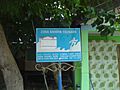
Tsunami warning bilingual sign in Ulee Lheue, Banda Aceh in Acehnese and Indonesian.

See also
 In Spanish: Tsunami para niños
