
2018 Sulawesi earthquake and tsunami facts for kids
| UTC time | 2018-09-28 10:02:43 |
|---|---|
| ISC event | 612780996 |
| USGS-ANSS | ComCat |
| Local date | 28 September 2018 |
| Local time | 6:02 pm |
| Magnitude | Mw 7.5 Ms 7.4 |
| Depth | 10.0 km |
| Epicentre | 0°10′41″S 119°50′24″E / 0.178°S 119.840°E |
| Type | Strike-slip |
| Max. intensity | IX (Violent) |
| Tsunami | Yes (highest 5 m (16 ft) in Palu) |
| Landslides | Yes |
| Foreshocks | Mw6.1, M5.4, M5.0 |
| Aftershocks | Five M≥5.5 |
| Casualties |
|
On September 28, 2018, a strong earthquake hit the Minahassa Peninsula in Indonesia. Its center was in the mountains of Donggala, Central Sulawesi. The earthquake happened about 77 kilometers (48 miles) from Palu, a big city. People felt the shaking far away in Samarinda and even in Tawau, Malaysia. Before the main quake, there were smaller quakes called foreshocks. The biggest foreshock was a magnitude 6.1 tremor earlier that day.
After the main earthquake, a tsunami warning was sent out for the nearby Makassar Strait. This warning was called off an hour later. However, a local tsunami still hit Palu. It swept away houses and buildings near the shore. The earthquake and tsunami together caused the deaths of at least 844 people. Another 540 people were injured. This event was the deadliest earthquake in Indonesia since 2009. It was also the deadliest earthquake of 2018.
The Indonesian Agency for Meteorology, Climatology and Geophysics (BMKG) confirmed the tsunami. Its waves reached an estimated height of 4 to 6 meters (13 to 20 feet). The tsunami hit the towns of Palu, Donggala, and Mamuju.
Contents
How the Earthquake Happened
Sulawesi is an island where several large land plates meet. These plates are always moving. The main active fault on northern Sulawesi is called the Palu-Koro fault. This fault moves sideways, about 30 to 40 millimeters (1.2 to 1.6 inches) each year. In Palu, there are several smaller faults that are part of this system.
The Earthquake Events
Smaller Earthquakes Before (Foreshocks)
The main earthquake was preceded by smaller quakes called foreshocks. These started about three hours earlier. The biggest foreshock was a magnitude 6.1 event. All these smaller quakes happened just south of where the main earthquake would hit.
The first foreshock happened at 3:00 PM local time. It was a shallow earthquake, about 10 kilometers (6 miles) deep. Its magnitude was 5.9. Strong shaking was felt in Donggala. At least one person died from falling debris. Ten others were injured. Many buildings were damaged or destroyed by this foreshock.
The Main Earthquake

The main earthquake's magnitude was first reported as 7.7. Later, it was changed to 7.5. Scientists studied the earthquake's movement. They found it was caused by a "strike-slip fault." This means the land blocks moved past each other horizontally. The earthquake happened because of movement on the Palu-Koro fault.
The main earthquake hit at 6:02 PM local time, during rush hour. People felt the shaking far away in Samarinda and Makassar. It was also felt in Gorontalo and Tawau, Malaysia. The shaking was very strong in Donggala and Palu. Power went out, and phone lines stopped working. More than 500 phone towers were damaged.
Indonesian officials could not contact anyone in Donggala at first. This town was closest to the earthquake's center. Contact was finally made two days later, on September 30.
Aftershocks
After the main earthquake, there were many smaller quakes called aftershocks. In the first 24 hours, 14 of these aftershocks were magnitude 5.0 or higher.
How Strong the Shaking Was
The earthquake was felt over a very large area. Light shaking was reported in Samarinda, Makassar, and Tawau. The strongest shaking was in Donggala Regency. Here, the shaking was rated as "violent." In Palu, the shaking was rated as "strong."
Scientists said the energy released by the quake was huge. It was 200 times more than the energy from the 1945 nuclear bombing of Hiroshima. The land near the fault in Palu and Donggala dropped in height. Some areas dropped by 0.5 to 1 meter (1.6 to 3.3 feet). Another area, Banawa, actually rose by about 0.3 centimeters (0.1 inches).
The Tsunami
A tsunami warning was issued for Palu and Donggala. Warnings were sent by text message. People in Donggala were told to expect waves 0.5 to 3 meters (1.6 to 10 feet) high. Palu residents were told to expect waves less than 0.5 meters (1.6 feet) high. However, the tsunami ended up being much higher than expected. People in Palu reported waves over 2 meters (6.6 feet) high. Some even said waves reached the second floor of buildings.
Officials calculated when the tsunami would arrive. They thought it would reach Palu about 20 minutes after the earthquake. Around 5:27 PM local time, tsunami waves were detected in Mamuju. The tsunami warning was called off at 5:37 PM. At that exact time, the tsunami hit Palu.
Palu is located at the end of a narrow bay. This shape made the tsunami's force even stronger as the water entered. Officials confirmed that the waves in Palu reached a height of 5 meters (16 feet). Some waves were nearly 6 meters (20 feet) high.
The tsunami surprised geologists. Strike-slip earthquakes usually cause small tsunamis. This is because the ground moves sideways, not up and down. Most large tsunamis happen when the ground moves vertically. One idea is that the earthquake caused underwater landslides. These landslides then created the large tsunami waves.
Damage Caused
In Palu, a mosque and a large part of the Antapura Hospital collapsed. Palu's Tatura Mall, an old shopping center, also collapsed. Dozens of people were trapped inside. An eight-story hotel, the Roa-Roa Hotel, also fell down. Many guests were trapped, including people attending a paragliding festival. Most of the hotel's rooms were full when the earthquake hit.
Palu's Mutiara SIS Al-Jufrie Airport had to close. Large cracks, one 500 meters (1,640 feet) long, appeared on the runway. The airport's navigation system was damaged, and the control tower collapsed. An air traffic controller died while watching a plane take off during the quake. The airport reopened for limited flights the next day. Hundreds of travelers were stuck there.
Officials confirmed that many homes were destroyed by the earthquake and tsunami. More than a thousand houses were gone. The tsunami also badly damaged ports in Palu. A large crane at Pantoloan Harbour fell and was swept away. Wani Harbour was damaged, and Ogoamas Harbour moved 3 centimeters (1.2 inches) sideways.
Palu's famous Kuning Ponulele Bridge was destroyed. This was Indonesia's first arch bridge. Roads leading to and from the city were also badly damaged. There were also reports of landslides.
Communication to the affected areas was very difficult. Local hospitals were damaged. The director of Palu Undata Hospital treated victims outside. He asked for tents, medicine, and nurses. A prison warden in Palu reported that many prisoners left the damaged prison.
In Donggala, prisoners also left their damaged prison. The prison was badly damaged.
Major "soil liquefaction" happened in Sigi Regency, south of Palu. This is when solid ground turns into a liquid-like mud. Many people saw a huge amount of liquid released from the soil. Buildings and structures were swept away. There were reports that an entire village disappeared.
Mudflows
After the earthquake and tsunami, some areas in Central Sulawesi were hit by large mudflows. These mudflows affected places that had survived the earlier events.
Most deaths were from the tsunami. But the mudflow was another major disaster. The Petobo area in Palu, about 10 kilometers (6 miles) inland, was hit by a mudflow. It is feared that 2,000 people died in this area. Homes were dragged away by the mud.
Images for kids
-
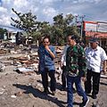
President Joko Widodo among collapsed buildings in Palu.
-
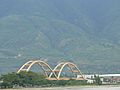
The Kuning Ponulele Bridge was destroyed in the earthquake (seen here in 2010).
-
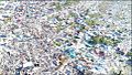
Balaroa, a district in Palu, was destroyed by the soil liquefaction after the earthquake.

_-_panoramio.jpg)

See also
 In Spanish: Terremoto de Célebes de 2018 para niños
