
Seismic magnitude scales facts for kids
When an earthquake happens, we need a way to measure how big it was and how much it shook the ground. That's where a seismic scale comes in! There are two main types of scales:
- Intensity scales tell us how strong the shaking felt in a specific place. This depends on how much damage happened there.
- Magnitude scales measure the actual power or "size" of the earthquake itself. This is usually figured out using special instruments.
The amount of shaking you feel in one spot depends on the earthquake's size and how far away you are from it. It also depends on the type of ground you're standing on!
Contents
What's the Difference: Magnitude vs. Intensity?
The Earth's outer layer, called the crust, is always under stress from huge forces called tectonic forces. Think of it like bending a ruler. When the stress gets too much, the crust can break or slip. This sudden movement releases a lot of energy, which travels as waves through the Earth. These waves make the ground shake.
Earthquake Magnitude: How Big Was It?
Magnitude is a way to estimate the overall "size" or strength of an earthquake. It tells us how much energy was released. A bigger magnitude means a more powerful earthquake. This scale helps us understand how much potential an earthquake has to cause shaking.

Ground Shaking Intensity: How Strong Did It Feel?
Intensity describes how strong the ground shaking felt in a particular spot. Before we had modern tools, people estimated intensity by looking at the damage caused. For example, if buildings fell down, the intensity was very high. If only a few dishes rattled, it was low.
Scientists can create an isoseismal map. This map uses lines to show areas where the shaking felt equally strong (like the image above). By looking at these maps, and seeing the strongest shaking, they can also estimate the earthquake's magnitude.
Why Does Shaking Vary?
The strength of shaking in a certain place isn't just about the earthquake's magnitude. Other things matter a lot, especially the ground conditions:
- Soft Soil: Areas with thick layers of soft soil, like loose dirt or sand, can make seismic waves much stronger. This can happen even far from where the earthquake started.
- Sedimentary Basins: These are bowl-shaped areas filled with soft rock and soil. They can act like a drum, making the shaking last longer.
For example, during the 1989 Loma Prieta Earthquake in California, the Marina district of San Francisco was badly damaged. This was surprising because it was nearly 100 kilometers (about 60 miles) from the earthquake's center! The reason was the soft, loose soil in that area. Also, the way seismic waves bounced off deep rock layers and traveled along faults made the shaking worse in some places.
Images for kids
-
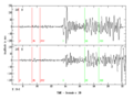
This is a typical seismogram, which records ground shaking. The first waves to arrive are fast P-waves (like sound waves). Then come S-waves, which shake sideways. These are "body-waves" that travel through the Earth. After them are "surface-waves" (Love and Rayleigh waves) that travel along the Earth's surface. For shallow earthquakes, surface waves are stronger and cause the most damage.
-
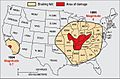
This map shows how the 1895 New Madrid earthquake (M ~6) was felt across much of the central U.S. In contrast, the 1994 Northridge quake (M 6.7), which was almost ten times stronger, was felt only in southern California. This difference is because the ground east of the Rocky Mountains in North America carries earthquake waves more easily.


See also
 In Spanish: Escalas de magnitud sísmica para niños
