
Landslide facts for kids

Landslides, also called landslips, are when a large amount of ground, rock, or debris moves down a slope. This can include many types of ground movement, like rockfalls (rocks falling), mudflows (mud moving like a river), and debris flows (a mix of water, mud, and rocks flowing).
Landslides can happen in many places. They occur on steep mountains, along coastal cliffs, or even underwater. When they happen underwater, they are called submarine landslides. Gravity is the main force that pulls a landslide down. But other things can make a slope more likely to slide. Often, a specific event triggers a landslide, like heavy rain, an earthquake, or when people cut into a slope to build a road. Sometimes, it's hard to tell what exactly caused it.
Contents
What Causes Landslides?

Landslides happen when a slope changes from being stable (safe) to unstable (likely to slide). This usually means the ground material becomes weaker, or the forces pushing it down become stronger. Sometimes, it's a mix of both. Many things, working alone or together, can cause a slope to become unstable.
Natural causes of landslides include:
- Too much water from rain, melting snow, or melting glaciers soaking into the ground.
- Rising groundwater levels or increased water pressure in the soil. This can happen after heavy rain.
- Water filling cracks and fractures in rocks, pushing them apart.
- Loss of plants and trees that hold the soil together. This can happen after a wildfire.
- Erosion of the bottom of a slope by rivers or sea waves.
- Weathering, like repeated freezing and thawing, which breaks down rocks and soil.
- Ground shaking from earthquakes. Earthquakes can make slopes unstable directly or create cracks that lead to landslides.
- Volcanic eruptions.
Human activities can also make landslides worse:
- Deforestation (cutting down trees), farming, and construction.
- Vibrations from machinery or traffic.
- Blasting and mining.
- Earthwork, like changing the shape of a slope or adding new weight to it.
- Removing deep-rooted vegetation that holds shallow soil to the solid rock below.
- Changes in how land is used, like farming or building cities. These changes can affect how much water soaks into the soil.
_1950,_2.jpg)
- When people stop farming in an area, the land can become weaker. This, along with heavy rain, can increase soil erosion and landslides.
Types of Landslides
Scientists have different ways to classify landslides. One way describes six main types of movement. These types can happen in both rock and soil.
- Fall: This is when isolated blocks or pieces of rock or soil fall freely down a slope.
- Topple: This happens when blocks of rock rotate and then fall away from a steep face.
- Slide: This is when a mass of material moves mostly as one piece over a surface that is tilted. The material usually stays together. Slides can be "planar" (moving on a flat surface) or "rotational" (moving on a spoon-shaped surface). They can happen suddenly or very slowly.
- Spread: This is a type of sinking where a layer of material cracks, opens up, and spreads out sideways.
- Flow: This is when material moves like a fluid. It can be dry or very wet, like in mudflows. Flows can move very slowly for years or speed up quickly and cause disasters.
- Slope deformation: These are slow, spread-out movements that can affect entire mountain slopes.
Some landslides are complex. They might involve different types of movement in different parts of the sliding mass. Or, they might start as one type and change into another. For example, a rock fall might break apart and turn into a debris flow.
Flows
When slope material gets completely soaked with water, it can create a debris flow or mud flow. Even dry debris can flow like a fluid. Flowing debris or mud can pick up trees, houses, and cars. It can also block bridges and rivers, causing flooding. This is very dangerous in mountain areas where narrow valleys make flows move faster.
Debris and mud flows can start on slopes or form when landslide material speeds up and picks up more debris and water. If a flow blocks a river, it can create temporary dams. When these dams break, it can cause a chain reaction, making the flowing mass much larger and more destructive.


An earthflow is when mostly fine-grained material (like clay or silt) moves downslope. Earthflows can move at very different speeds, from a few millimeters per year to many kilometers per hour. They are similar to mudflows but usually move slower. They are often covered with solid material carried along by the flow. Earthflows are usually controlled by the water pressure inside the moving mass. They often happen during periods of heavy rain.
A rock avalanche, sometimes called a sturzstrom, is a very large and fast-moving landslide of the flow type. It is rare but often very destructive. It can flow very far, even over flat or slightly uphill ground. Scientists are still trying to fully understand why they can travel so far. It might involve the sliding area getting very hot from friction, causing water to turn into steam and create a cushion. This is similar to how seismic faults work during earthquakes.
Slides
Slides can happen in any type of rock or soil. They involve a mass of material moving over a flat or curved surface.
A debris slide is a type of slide where material mixed with water or ice moves in a messy way. It often starts when thickly vegetated slopes get soaked with water. This creates a mix of broken trees, plants, and other debris. Debris flows and avalanches are different because they move more like fluids and are usually much faster.
Clay and silt slides are usually slow. But they can speed up after heavy rainfall or rapid snowmelt. They are often seen on gentle slopes and move over flat surfaces, like over the bedrock below.
Shallow and Deep-seated Landslides

A shallow landslide is one where the sliding surface is close to the surface, usually a few feet deep. Debris slides and debris flows are often shallow. Shallow landslides can happen in areas where permeable soil (soil that lets water through) sits on top of less permeable soil (soil that traps water). The trapped water builds up pressure, making the top soil unstable and causing it to slide.


Deep-seated landslides are those where the sliding surface is much deeper, often well below the roots of trees. They usually involve deep soil, weathered rock, or solid rock. They include large slope failures that move by sliding, rotating, or a mix of both. They tend to form along weak spots in the ground, like a fault or bedding plane. You can often spot them by curved scarps (steep slopes) at the top and steep areas at the bottom.
Landslides Causing Tsunamis
Landslides that happen underwater, or large rockfalls or volcanic collapses that fall into the sea, can create tsunamis. Very large landslides can even cause megatsunamis, which are often hundreds of meters high. In 1958, a tsunami caused by a landslide happened in Lituya Bay in Alaska.
Related Phenomena
- An avalanche is similar to a landslide. It involves a large amount of ice, snow, and rock falling quickly down a mountain.
- A pyroclastic flow is caused by a collapsing cloud of hot ash, gas, and rocks from a volcanic explosion. It moves very fast down an erupting volcano.
Predicting Landslides
Mapping areas where landslides are likely to happen can help reduce damage and save lives. It also helps in planning how land should be used. Scientists study factors related to landslides, like the shape of the land, the type of rock, how land is used, and how water moves through the ground. They use this information to predict where landslides might happen in the future.
Because many factors are involved, GIS (Geographic Information Systems) is a useful tool. GIS helps collect, store, and analyze large amounts of map data quickly. Remote sensing techniques, like using aerial photographs and satellite images, are also used. By looking at images from before and after landslides, scientists can learn about how they happen and what triggers them. This also shows how the landscape changes and recovers.
By combining satellite images with GIS and studies on the ground, scientists can create maps that show where future landslides are likely. These maps show where past landslides occurred and where new ones might happen. To predict landslides, scientists assume that future landslides will happen under similar conditions as past ones.
Natural disasters like landslides show how people live with the environment. Early predictions and warnings are very important to reduce property damage and loss of life. Since landslides happen often and can be very destructive, it's important to understand what causes them. This helps people prevent them or avoid them when they occur. Planning land use carefully is also key to reducing the negative effects of landslides.

GIS is great for landslide analysis because it can handle a lot of data quickly. Since many things affect landslides, GIS helps layer all the data to get a full picture of what's happening on the Earth's surface. Researchers need to know which factors are most important in triggering landslides in different places. Using GIS, very detailed maps can be made to show past and likely future events. This can save lives, property, and money.
Since the 1990s, GIS has also been used with decision support systems. These systems show real-time risk on a map based on monitoring data. An example is the area of the Val Pola disaster in Italy.
-
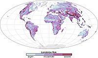
Global landslide risks
-
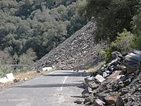
Ferguson Slide in California in June 2006
-
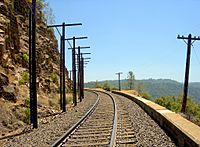
A detector that warns of rock slides on train tracks in California.


Prehistoric Landslides

Some of the biggest landslides happened long ago, before humans kept records:
- The Storegga Slide: This happened about 8,000 years ago off the coast of Norway. It caused huge tsunamis in areas like Doggerland and other countries connected to the North Sea. The amount of debris was huge, like a 34-meter thick area the size of Iceland. It's thought to be one of the largest landslides ever.
- The Heart Mountain landslide: This moved Heart Mountain to its current spot. It's the largest continental landslide found so far.
- The Flims Rockslide: This happened about 10,000 years ago in Switzerland. It's the largest landslide described in the Alps and on dry land that is still easy to see.
- The landslide that formed Lake Waikaremoana: Around 200 BC in New Zealand, a large block of a mountain slid and blocked a river gorge. This created a natural lake up to 256 meters deep.
- The Manang-Braga rock avalanche/debris flow: This may have formed the Marsyangdi Valley in Nepal. It's estimated that over 15 cubic kilometers of material moved in this single event, making it one of the largest continental landslides.
Historical Landslides
Here are some notable landslides from history:
- The 1806 Goldau landslide in Switzerland on September 2, 1806.
- The Cap Diamant Québec rockslide in Canada on September 19, 1889.
- Frank Slide, Turtle Mountain, Alberta, Canada, on April 29, 1903.
- Khait landslide, Tajikistan, on July 10, 1949.
- A Magnitude 7.5 earthquake in Yellowstone Park (August 17, 1959) caused a landslide that blocked the Madison River, creating Quake Lake.
- Monte Toc landslide in Italy, falling into the Vajont Dam basin on October 9, 1963. This caused a megatsunami and about 2000 deaths.
- Hope Slide landslide near Hope, British Columbia on January 9, 1965.
- The 1966 Aberfan disaster in Wales.
- Tuve landslide in Gothenburg, Sweden on November 30, 1977.
- The 1979 Abbotsford landslip, Dunedin, New Zealand on August 8, 1979.
- The eruption of Mount St. Helens (May 18, 1980) caused a huge landslide when the top of the volcano collapsed.
- Val Pola landslide during the Valtellina disaster (1987) in Italy.
- Thredbo landslide, Australia on July 30, 1997, which destroyed a hostel.
- Vargas mudslides in Vargas State, Venezuela, in December 1999. These were caused by heavy rains and led to tens of thousands of deaths.
- 2005 La Conchita landslide in Ventura, California, causing 10 deaths.
- 2007 Chittagong mudslide, in Chittagong, Bangladesh, on June 11, 2007.
- 2008 Cairo landslide on September 6, 2008.
- The 2010 Uganda landslide caused over 100 deaths after heavy rain in the Bududa region.
- Zhouqu county mudslide in Gansu, China on August 8, 2010.
- Devil's Slide, an ongoing landslide in San Mateo County, California.
- 2011 Rio de Janeiro landslide in Rio de Janeiro, Brazil on January 11, 2011, causing 610 deaths.
- 2014 Pune landslide, in Pune, India.
- 2014 Oso mudslide, in Oso, Washington.
- 2017 Mocoa landslide, in Mocoa, Colombia.
Landslides on Other Planets
Scientists have found signs of past landslides on many planets and moons in our solar system. Since most observations are made by probes that only watch for a short time, not many recent landslides are known. But both Venus and Mars have been mapped by orbiting satellites, and examples of landslides have been seen on both planets.
-
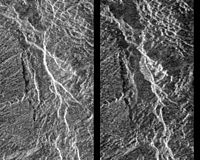
Before and after radar images of a landslide on Venus (1990). The new landslide is the bright, flow-like area.
-
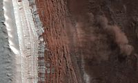
A landslide happening on Mars, February 19, 2008.


See also
 In Spanish: Corrimiento de tierra para niños
