1979 Abbotsford landslip facts for kids
On August 8, 1979, a huge landslip happened in Abbotsford, a suburb of Dunedin, New Zealand. This was the biggest landslip ever in a built-up area in New Zealand's history. It destroyed 69 houses, which was about one-sixth of the whole suburb. Luckily, no one died.
Contents
What is the Abbotsford Landslip?
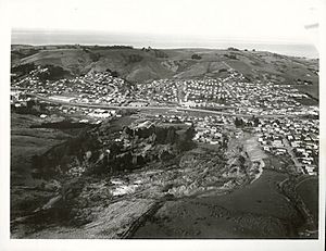
The Abbotsford landslip was a massive movement of earth. It happened in the suburb of Abbotsford, which is in the southwest part of Dunedin. This area is on the side of a hill. The larger suburb of Green Island is just south of it. Between them is a valley with the Kaikorai Stream.
Why the Land Moved: The Ground Beneath
Much of Abbotsford was built on ground that wasn't very stable. Below the hard rock, there was a thick layer of soft mudstone. On top of that was sand and clay-rich soil. This kind of ground gets very slippery when it rains a lot. Landslips have happened in the wider Dunedin area before, both long ago and more recently.
The land was also on a slope. Digging for quarries and building the nearby Dunedin Southern Motorway in the 1960s and 1970s might have made the ground even less stable. The landslip wasn't caused by an earthquake. Instead, heavy rain over many years made the slope give way. This happened because of clay layers that were parallel to the ground's layers.
Signs Before the Landslip
There had been many smaller landslips in Abbotsford before. One happened in 1914 when the Dunedin-Mosgiel railway was being built. Even a 1951 report from the University of Otago said the land wasn't good for building. But the area was still chosen for new houses.
Early Warnings and Problems
When the area was developed, extra water channels were built. These were meant to handle heavy rain. But they weren't enough for very big downpours. Christie Street, which goes up Abbotsford hill, existed before World War II. But many new houses were built around it starting in 1953.
Some houses had to be knocked down because of slips during the building of the Dunedin Southern Motorway. This happened in 1966 and 1968. From 1968, cracks started showing up in houses on Christie Street. More signs of the ground moving became common in the years that followed.
Growing Concerns and Evacuations
In November 1978, water pipes broke in Christie Street. In May 1979, the Green Island Borough Council had to replace drains that had pulled apart. More water and sewer pipes broke in June. Between July 1 and July 16, four houses were emptied. Six more became empty by the end of the month.
During July, government ministers Bill Young and Derek Quigley visited the area. But the Prime Minister, Robert Muldoon, didn't declare a state of emergency. He also didn't allow full payment for damaged houses.
By mid-July, the land was moving about 25 millimeters (one inch) every day. People talked about the chance of a big slip. But they thought there would be plenty of warning. So, residents were not officially told to leave, though some left on their own. Heavy rain in late July made the land move even faster. People who didn't live there were not allowed to visit the area.
By early August, the land was moving over one meter (about three feet) per day. More houses were emptied. The mayor of Green Island, Vic Crimp, finally declared a state of emergency on August 6. The area was partly evacuated. Plans were made on August 7 for everyone to leave. But this wasn't finished before the big slip happened.
The Hill Gives Way
At about 9:07 PM on August 8, Abbotsford hill suddenly moved. About 18 hectares (44 acres) of land moved. Nearly half of this was residential land. It slid 48 meters (157 feet) down the hill in just 15 minutes. This land included most of the eastern side of Christie Street. It also included parts of Mitchell and Edward Streets, Gordon Street, and Charles Street. A large area of open land also moved.
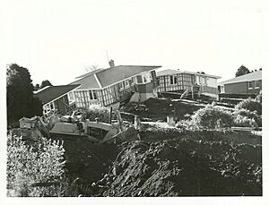
Sixty-nine houses were destroyed. Some were directly hit by the slip. Others had to be knocked down later because they were unsafe. At the bottom of the hill, parts of Miller Park sports ground and Armstrong Lane were covered.
The slip involved about 5 million cubic meters of sand and loose soil. This material was up to 40 meters (131 feet) thick. A 150-meter (492-foot) wide crack, up to 16 meters (52 feet) deep, was left at the top of the slip.
Hundreds of people lost their homes. But, luckily, no one died. The worst injuries were very minor. Some residents only had seconds to leave their houses. A group of seventeen people had to be rescued from a small piece of land that was moving.
After the Landslip
The state of emergency lasted until August 18. The total damage was estimated to be between 10 and 13 million New Zealand dollars. Some houses survived the slide quite well. They were moved to new places.
A special investigation looked into why the slip happened. It met for 58 days and released its report in November 1980. The investigation found that the area was naturally likely to have slips. It had weak clay layers that could become unstable. The situation was made worse by removing sand from the bottom of the hill at a quarry. Building the houses and the motorway also made it worse.
The Abbotsford landslip led to big changes in how buildings and land developments are approved in New Zealand. Now, experts check the ground's geology before any land is developed. Rules for land cover and landslip insurance were also changed a lot in 1984 because of this event.
Much of the land that slipped has since been turned into parkland. Trees have been planted to help make the earth more stable.
 | Chris Smalls |
 | Fred Hampton |
 | Ralph Abernathy |


