
1980 eruption of Mount St. Helens facts for kids
On May 18, 1980, a huge volcanic eruption happened at Mount St. Helens. This volcano is located in Washington, a state in the United States. The eruption was so powerful that it was given a score of 5 on the Volcanic Explosivity Index, which measures how big eruptions are.
For about two months before the main eruption, there were many earthquakes around the volcano. Also, steam started coming out of the volcano's top. Sadly, 57 people lost their lives in this eruption. Among them were Harry R. Truman, who lived near Spirit Lake, and David A. Johnston, a scientist who studied volcanoes.
Contents
What Happened at Mount St. Helens?
Mount St. Helens is a volcano in the Cascade Range in Washington state. Before 1980, it was a beautiful, cone-shaped mountain. But on May 18, 1980, it changed forever.
Signs Before the Eruption
For weeks before the big blast, Mount St. Helens showed signs it was waking up.
- Earthquakes: Many small earthquakes shook the ground beneath the volcano. This meant magma (hot, melted rock) was moving inside.
- Steam Vents: Steam and ash started puffing out of the top. This showed that gases were building up.
- Bulge on the Side: A large bulge, or bump, grew on the north side of the mountain. This bulge was caused by magma pushing up from inside. It grew by about 5 feet (1.5 meters) each day!
The Big Blast on May 18, 1980
The eruption on May 18, 1980, was not like typical volcano eruptions.
- Landslide: First, a huge landslide happened. The entire north side of the mountain collapsed. This was the largest landslide ever recorded.
- Lateral Blast: When the side of the mountain collapsed, it released the pressure inside. This caused a powerful sideways blast of hot gas, ash, and rock. This blast flattened forests for miles around.
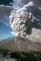
- Ash Cloud: A massive ash cloud shot into the sky, reaching about 15 miles (24 km) high. The ash traveled across the United States, making skies dark and covering towns in ash.
- Pyroclastic Flows: Hot, fast-moving currents of gas and rock, called pyroclastic flows, rushed down the volcano's slopes.
- Lahars: The heat melted snow and ice, creating huge mudflows called lahars. These mudflows flowed down rivers, destroying bridges and homes.
Impact on the Landscape
The eruption completely changed the area around Mount St. Helens.
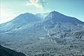
- Crater: The top of the mountain was blown away, leaving a huge, horseshoe-shaped crater.
- Forests Destroyed: Millions of trees were knocked down or scorched by the blast.
- Spirit Lake: Spirit Lake, a popular lake near the volcano, was filled with logs and debris. Its water level rose dramatically.
People Affected
Even though scientists warned people, 57 people died. Most were outside the danger zone but were caught by the fast-moving blast or ash.
- Harry R. Truman: He was an 83-year-old man who refused to leave his home near Spirit Lake. He became a symbol of the eruption.
- David A. Johnston: He was a volcanologist (a scientist who studies volcanoes) who was at an observation post a few miles from the volcano. He warned others about the eruption but was caught in the blast.
Recovery and New Growth
After the eruption, the area around Mount St. Helens looked like a wasteland. But over time, nature started to recover.
- New Life: Plants and animals slowly returned to the blast zone. Scientists studied how life came back to the damaged land.
- Lava Dome: A new lava dome began to grow inside the crater. This shows the volcano is still active.
- Monitoring: Scientists continue to watch Mount St. Helens closely. They use special tools to detect earthquakes and gas releases. This helps them predict future eruptions and keep people safe.
The 1980 eruption of Mount St. Helens was a powerful reminder of nature's force. It also taught scientists a lot about how volcanoes work and how landscapes recover after such a big event.
Images for kids
-

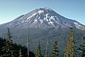
Mount St. Helens from Monitor Ridge, this image shows the cone of devastation, the huge crater open to the north, the posteruption lava dome inside, and Crater Glacier surrounding the lava dome. The small photo on the left was taken from Spirit Lake before the eruption and the small photo on the right was taken after the eruption from roughly the same place. Spirit Lake can also be seen in the larger image, as well as two other Cascade volcanoes.
-
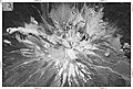
USGS photo showing a pre-avalanche eruption on April 10
-
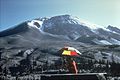
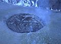
Photo showing the cryptodome on April 27
-
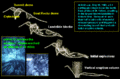
Sequence of events on May 18
-
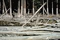
Lakes nearest to Mount St. Helens have been partly covered with felled trees for more than 40 years. This photograph was taken in 2012.
-
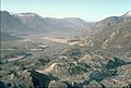
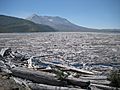
North Fork Toutle River valley filled with landslide deposits
-
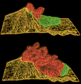
Computer graphics showing the May 18 landslide (green) being overtaken by the initial pyroclastic flow (red)
-
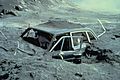
Photographer Reid Blackburn's Volvo after the eruption
-
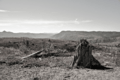
Many trees in the direct blast zone were snapped off at their bases and the earth was stripped and scorched.
-
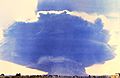
The ash cloud produced by the eruption, as seen from the village of Toledo, Washington, 35 miles (56 km) to the northwest of Mount St. Helens: The cloud was roughly 40 mi (64 km) wide and 15 mi (24 km; 79,000 ft) high.
-
Ash cloud from Mt. St. Helens as captured by the GOES 3 weather satellite at 15:45 UTC.
-
Residual lateral blast effects in the channelized blast zone, some 30 years after the eruption: Damage ranged from scorched earth, through tree trunks snapped at various heights, to more superficial effects.
-
Mudline next to Muddy River from the 1980 lahars
-
Mount St. Helens one day before the eruption, photographed from the Johnston ridge
-
Mount St. Helens four months after the eruption, photographed from roughly the same location as was the earlier picture: Note the barrenness of the terrain as compared to the image above.
-
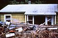
One of the 200 houses destroyed by the eruption
-
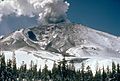
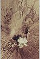
Eruption on July 22, 1980
-
The growing third dome on October 24, 1980
-
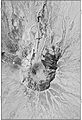
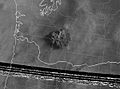
Satellite image of Mount St. Helens crater (22 July 1982)
-
Satellite image of Mount St. Helens crater 30 June 1980 (color infrared)
-
Satellite image of Mount St. Helens before eruption (23 July 1975)
-
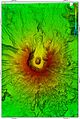
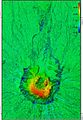
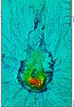
Digital elevation model (DEM) of Mount St. Helens (1982)
-
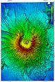
DEM of Mount St. Helens (2003)
-
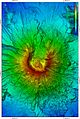
DEM of Mount St. Helens (2017)
-
Lava domes growth and landscape change of Mount St. Helens 2002-2017
-
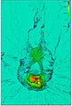
Lava domes growth and landscape change of Mount St. Helens 1982-2003
-
Lava domes growth and landscape change of Mount St. Helens 1982-2017


_satellite_image_of_Mount_St,_Helens_crater_.jpg)
_satellite_image_of_Mount_St,_Helens_1980_color_infrared..jpg)
_satellite_image_of_Mount_St,_Helens..jpg)


See also
 In Spanish: Erupción del monte Santa Helena de 1980 para niños
