
Washington (state) facts for kids
Quick facts for kids
Washington
|
|||||
|---|---|---|---|---|---|
|
|||||
| Nickname(s):
"The Evergreen State" (de facto)
|
|||||
| Motto(s):
Alki (Chinook jargon for 'By and By')
|
|||||
| Anthem: "Washington, My Home" |
|||||

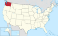
Location of Washington within the United States
|
|||||
| Country | United States | ||||
| Before statehood | Washington Territory | ||||
| Admitted to the Union | November 11, 1889 (42nd) | ||||
| Capital | Olympia | ||||
| Largest city | Seattle | ||||
| Largest county or equivalent | King | ||||
| Largest metro and urban areas | Seattle | ||||
| Legislature | State Legislature | ||||
| • Upper house | State Senate | ||||
| • Lower house | House of Representatives | ||||
| Judiciary | Washington Supreme Court | ||||
| U.S. senators | Patty Murray (D) Maria Cantwell (D) |
||||
| U.S. House delegation | 8 Democrats 2 Republicans (list) |
||||
| Area | |||||
| • Total | 71,362 sq mi (184,827 km2) | ||||
| • Land | 66,544 sq mi (172,587 km2) | ||||
| • Water | 4,757 sq mi (12,237 km2) 6.6% | ||||
| Area rank | 18th | ||||
| Dimensions | |||||
| • Length | 240 mi (400 km) | ||||
| • Width | 360 mi (580 km) | ||||
| Elevation | 1,700 ft (520 m) | ||||
| Highest elevation | 14,400 ft (4,389 m) | ||||
| Lowest elevation
(Pacific Ocean)
|
0 ft (0 m) | ||||
| Population
(2025)
|
|||||
| • Total | |||||
| • Rank | 13th | ||||
| • Density | 103/sq mi (39.6/km2) | ||||
| • Density rank | 22nd | ||||
| • Median household income | $94,600 (2023) | ||||
| • Income rank | 7th | ||||
| Demonym(s) | Washingtonian | ||||
| Language | |||||
| • Official language | None (de jure) English (de facto) |
||||
| Time zone | UTC−08:00 (Pacific) | ||||
| • Summer (DST) | UTC−07:00 (PDT) | ||||
| USPS abbreviation |
WA
|
||||
| ISO 3166 code | US-WA | ||||
| Traditional abbreviation | Wash. | ||||
| Latitude | 45°33′ N to 49° N | ||||
| Longitude | 116°55′ W to 124°46′ W | ||||
|
|||||


| Dance | Square dance |
|---|---|
| Bird | American goldfinch |
| Fish | Steelhead trout |
| Flower | Rhododendron |
| Tree | Western hemlock |
| Insect | Green darner |
| Vegetable | Sweet onion |
| Sport | Pickleball |
Washington, officially the State of Washington, is a state in the Pacific Northwest region of the United States. People often call it Washington State to tell it apart from the nation's capital. Both places are named after George Washington, the first U.S. president.
Washington borders the Pacific Ocean to the west, Oregon to the south, and Idaho to the east. To the north, it shares a border with the Canadian province of British Columbia. Olympia is the state capital, and Seattle is its largest city.
Washington is the 18th largest state by land area and the 13th most populated. It has almost 8 million people. Most people live in the Seattle metropolitan area. This area is a major hub for transportation, business, and industry. It is located on Puget Sound, which is an inlet of the Pacific Ocean with many islands and deep bays.
The rest of the state has deep temperate rainforests in the west. There are also mountain ranges in the west, center, northeast, and southeast. The eastern part of the state has a dry, semi-arid region used for farming. Washington is the second most populated state on the West Coast, after California. Mount Rainier, an active volcano, is the state's highest point. It is also the most prominent mountain in the contiguous U.S..
Washington is a top producer of lumber. It also grows the most apples, hops, pears, blueberries, spearmint oil, and sweet cherries in the U.S. The state also produces a lot of apricots, asparagus, peas, grapes, lentils, peppermint oil, and potatoes. Raising livestock and commercial fishing, especially for salmon and halibut, are also important to the state's economy. Washington is third in the country for wine production. Its factories make aircraft, missiles, ships, food products, metals, chemicals, and machinery.
The state was created from the western part of the Washington Territory. This land was given by the British Empire in the Oregon Treaty of 1846. Washington became the 42nd state to join the U.S. in 1889. It is one of the wealthiest states and is known for being very open-minded. Washington often ranks high for life expectancy and job rates.
Contents
- Naming the State of Washington
- History of Washington State
- Geography of Washington State
- Plants and Animals of Washington
- Cities and Counties in Washington
- People and Population
- Washington's Economy
- Transportation in Washington
- Environment in Washington
- Utilities and Energy
- Government and Politics
- Education in Washington
- Media in Washington
- Health Care in Washington
- Culture and Sports
- State Symbols and Names
- Images for kids
- See also
Naming the State of Washington
Washington was named after President George Washington. This happened when the United States Congress created the Washington Territory in 1853. The territory was first going to be called "Columbia." This name came from the Columbia River and the Columbia District. However, a representative from Kentucky, Richard H. Stanton, thought "Columbia" was too much like the District of Columbia. So, he suggested naming the new territory after President Washington instead. This makes Washington the only U.S. state named after a president.
People sometimes get the state of Washington confused with Washington, D.C. Because of this, there were ideas to rename the state when it was becoming a state in 1889. One idea was to call it "Tacoma." But these ideas did not get enough support. People who live in Washington state usually just call it "Washington." They call the nation's capital "Washington, D.C.," "the other Washington," or simply "D.C."
History of Washington State
Early Times in Washington

The remains of Kennewick Man, a very old human skeleton, were found in Washington in the 1990s. This shows that people lived here over 9,300 years ago. For thousands of years, many Native American tribes lived in this region. They were known for their detailed carvings, canoes, longhouses, and masks. Fishing for salmon was very important to them. The Makah tribe was also known for whale hunting. People living inland had a different way of life. They hunted, gathered food, and did some farming. They also relied on salmon from the Columbia River.
The area has also experienced very strong earthquakes in the past. The last big one was the Cascadia earthquake in 1700.
European Explorers Arrive
The first European to record landing on the Washington coast was Spanish Captain Don Bruno de Heceta in 1775. He claimed the coastal lands for Spain. Soon after, a smallpox epidemic in the 1770s greatly reduced the Native American population.
In 1778, British explorer Captain James Cook saw Cape Flattery. This is at the entrance to the Strait of Juan de Fuca. However, Cook did not realize the strait was there. It was later discovered by Charles William Barkley in 1787. Other explorers, like Manuel Quimper, Francisco de Eliza, and George Vancouver, explored the straits more in the 1790s.
European Settlements Begin
The British and Spanish signed the Nootka Convention in 1790. This agreement ended Spain's claim to own all the Northwest Coast. It opened the area to explorers and traders from other countries, including Britain, Russia, and the United States. American captain Robert Gray discovered the mouth of the Columbia River. He named the river after his ship, the Columbia. The Lewis and Clark Expedition entered the state on October 10, 1805.
.jpg)
Britain and the United States agreed to share the land west of the Continental Divide to the Pacific Ocean. This was part of the Anglo-American Convention of 1818. This treaty set the 49th parallel as the border from Lake of the Woods to the Rocky Mountains. In 1819, Spain gave its claims north of the 42nd parallel to the United States.
Over the next few decades, Britain and the U.S. argued about the border. Many American settlers moved into Oregon Country. The Hudson's Bay Company, a British fur trading company, tried to keep British control of the area. Despite these efforts, Britain eventually gave up all claims to land south of the 49th parallel to the United States. This happened with the Oregon Treaty on June 15, 1846.
In 1836, missionaries like Marcus Whitman started settlements in what is now southeastern Washington. This area was home to the Cayuse and Nez Perce tribes. Whitman's settlement helped the Oregon Trail become a path for thousands of settlers moving west. Whitman provided medical care to Native Americans. However, many Native American patients died from new diseases they had no immunity to. At the same time, many white patients recovered. The tribes blamed Whitman and killed him and twelve other settlers in 1847. This event led to the Cayuse War between settlers and Native Americans.
Fort Nisqually, a trading post, was the first European settlement in the Puget Sound area. It was founded in 1833. In 1846, George Washington Bush, a Black pioneer, and his wife, Isabella, led families into the territory. They founded New Market, now Tumwater. They settled in Washington to avoid Oregon's law that stopped African Americans from entering the territory. After them, many more settlers moved north to the Puget Sound area.
Becoming a State

The population north of the Columbia River grew, and people wanted a new territory. The U.S. Congress created Washington Territory on March 2, 1853. The territory's border first went farther east, including parts of Idaho and Montana. When Idaho Territory was created in 1863, Washington's eastern border became final.
Washington became the 42nd state of the United States on November 11, 1889.
Early important industries in the new state were farming and lumber. In Eastern Washington, the Yakima River Valley became known for its apple orchards. Growing wheat without much rain also became very successful. Heavy rainfall west of the Cascade Range created thick forests. Ports along Puget Sound grew wealthy from making and shipping lumber products, especially Douglas fir. Other industries that grew in the state included fishing, salmon canning, and mining.
Modern Washington History

For a long time, Tacoma had large factories that processed gold, silver, copper, and lead ores. Seattle was the main port for trade with Alaska and other parts of the country. For a while, it had a large shipbuilding industry. The area around eastern Puget Sound developed heavy industries during World War I and World War II. The Boeing company became a well-known symbol in the area.
During the Great Depression, many hydroelectric dams were built along the Columbia River. This project aimed to produce more electricity. In 1941, the Grand Coulee Dam was finished. It was the largest concrete structure in the United States at the time.
During World War II, Washington became important for war industries. The Boeing Company made many heavy bombers. Ports in Seattle, Bremerton, Vancouver, and Tacoma built warships. Seattle was a departure point for many soldiers going to the Pacific. In Eastern Washington, the Hanford Works atomic energy plant opened in 1943. It played a big role in making atomic bombs.
After World War II, the state's growing Black population saw their wages increase. Efforts were made to reduce discrimination in workplaces. In 1950, Seattle elected its first Black representative to the state's legislature.

On May 18, 1980, Mount St. Helens erupted violently. This happened after many tremors and small eruptions. The north face of the mountain slid off in the largest landslide ever recorded. The eruption destroyed forests up to 20 kilometers (12 miles) north of the volcano. It killed 57 people and filled the Columbia River with ash and mud. Large parts of Washington and other states to the east were covered in ash, making day look like night.
Geography of Washington State

Washington is the northwesternmost state in the contiguous United States. It borders Idaho to the east and Oregon to the south. The Pacific Ocean is to its west. To the north, it shares a border with the Canadian province of British Columbia.
The tall Cascade Range mountains run north to south, dividing the state into two main parts. People call these parts "Western Washington" and "Eastern Washington." They also use names like "Westside" and "Eastside," or "Wet side" and "Dry side." These names describe the different geography, climate, and industries on each side of the Cascades.
Western Washington's Landscape

West of the Cascade Mountains, Western Washington has a mild climate with wet winters, autumns, and springs, and fairly dry summers. The Cascade Range has several volcanoes. These include Mount Baker, Glacier Peak, Mount Rainier, Mount St. Helens, and Mount Adams. All of them are active volcanoes.
Mount Rainier is the tallest mountain in the state. It is about 50 miles (80 km) south of Seattle and can be seen clearly from the city. The United States Geological Survey considers Mount Rainier the most dangerous volcano in the Cascade Range. This is because it is close to the Seattle metropolitan area. It also has more glacial ice than any other peak in the lower 48 states.
Western Washington also has the Olympic Mountains on the Olympic Peninsula. These mountains have thick forests of evergreen trees and areas of temperate rainforest. These deep forests, like the Hoh Rainforest, are some of the only rainforests in the continental U.S. Western Washington has many rainy days each year, even if the total amount of rain isn't always the highest.
Eastern Washington's Landscape
Eastern Washington, east of the Cascades, has a much drier climate. It includes large areas of dry grasslands and some very dry deserts. This is because the Cascades block much of the rain. For example, the Hanford reservation gets only about 6 to 7 inches (15 to 18 cm) of rain each year.
Even with little rainfall, agriculture is very important in Eastern Washington. The soil is very fertile, and irrigation from dams along the Columbia River helps crops grow. Cities in Eastern Washington are usually located near rivers or lakes, which provide water.
Farther east, the climate becomes less dry. The Okanogan Highlands and the Kettle River Range cover much of the state's northeastern part. The Palouse region in the southeast was once grassland. Now, it is mostly farmland and extends to the Blue Mountains.
Washington's Climate and Weather

Washington has a mild climate. The eastern half of the state has a dry to warm-summer climate. The western side and coastal areas have a cool ocean climate. The Pacific Ocean and the Olympic and Cascade mountains greatly affect Washington's weather.
In spring and summer, a high-pressure system over the Pacific brings cool air and dry weather to Washington. In autumn and winter, a low-pressure system brings cool, cloudy, and wet weather. Western Washington is very cloudy during much of fall, winter, and early spring. Seattle gets less sunshine than most other major U.S. cities.
Even with its mild climate, Western Washington has had very cold winters and heavy snowfalls in the past. The lowest temperature ever recorded in Seattle was 0°F (−18°C) on January 31, 1950. Some low-altitude areas away from Seattle have recorded temperatures as low as −48°F (−44°C).
Rain Shadow Effects

Rainfall in Washington changes a lot from west to east. The western side of the Olympic Peninsula gets as much as 160 inches (406 cm) of rain each year. This makes it the wettest area in the lower 48 states and a temperate rainforest. Weeks can pass without a clear day there. The western slopes of the Cascade Range get some of the heaviest snowfall in the country.
East of the Cascades, a large area gets very little rain. This is called a rain shadow. The dry conditions are found in much of Eastern Washington. This is especially true in the central Columbia Plateau, just east of the Columbia River. Because of this, much of Eastern Washington has dry grassland, shrub-steppe, and dunes instead of rainforests.
Temperatures Across the State
The average yearly temperature in Washington ranges from 51°F (11°C) on the Pacific coast to 40°F (4°C) in the northeast. The lowest temperature ever recorded in the state was −48°F (−44°C) in Winthrop and Mazama. The highest temperature recorded was 120°F (49°C) at Hanford on June 29, 2021. Both of these record temperatures were set east of the Cascades.
Western Washington is known for its mild climate, frequent fog, and cloudy skies. It has long drizzles in the winter and warm, mild summers. The eastern region, which doesn't get the ocean's moderating effect, sometimes has extreme weather. Cold fronts in winter and heat waves in summer are common there.
Plants and Animals of Washington


Forests cover about half of Washington's land, mostly west of the northern Cascades. About two-thirds of these forests are publicly owned. Common trees and plants include Douglas fir, hemlock, ponderosa pine, and western red cedar. The state's wild areas provide homes for many shorebirds and marine mammals. The Pacific shore around the San Juan Islands has many killer, gray, and humpback whales.
In Eastern Washington, the plants are very different. Tumbleweeds and sagebrush are common in much of the countryside. Russian olives and other trees grow along riverbanks. However, large parts of Eastern Washington have no naturally growing trees at all. A wider variety of plants can be found in the Blue Mountains and the eastern sides of the Cascades.
Mammals native to Washington include the black bear, bobcat, cougar, coyote, deer, elk, gray wolf, moose, raccoon, and skunk. Because of its varied geography, Washington is home to many different bird species. These include raptors, shorebirds, woodland birds, and ducks. Many species have also been brought to Washington since the 1700s, like horses.
The state has many different types of fish, including channel catfish, lamprey, and sturgeon. There are also several kinds of snakes and amphibians. Coastal bays and islands often have many shellfish and whales. Five types of salmon swim up streams in Western Washington to lay their eggs.
Washington has several National Park Service areas. These include Olympic National Park, North Cascades National Park, and Mount Rainier National Park. Almost 95 percent of Olympic National Park is protected as wilderness. There are also 143 state parks and 9 national forests. The Okanogan National Forest is the largest national forest on the West Coast.
Cities and Counties in Washington
There are 39 counties in Washington state. There are also 281 cities and towns. Most of the state's population lives in Western Washington, in the Seattle metropolitan area. Seattle is the main city of this area, with a population of 737,015 in 2020.
| Rank | Name | Pop. |
|---|---|---|
| 1 | Seattle | 737,015 |
| 2 | Spokane | 228,989 |
| 3 | Tacoma | 219,346 |
| 4 | Vancouver | 190,915 |
| 5 | Bellevue | 151,854 |
| 6 | Kent | 136,588 |
| 7 | Everett | 110,629 |
| 8 | Renton | 106,785 |
| 9 | Spokane Valley | 102,976 |
| 10 | Federal Way | 101,030 |
People and Population
Washington's Growing Population
| Historical population | |||
|---|---|---|---|
| Census | Pop. | %± | |
| 1850 | 1,201 | — | |
| 1860 | 11,594 | 865.4% | |
| 1870 | 23,955 | 106.6% | |
| 1880 | 75,116 | 213.6% | |
| 1890 | 357,232 | 375.6% | |
| 1900 | 518,103 | 45.0% | |
| 1910 | 1,141,990 | 120.4% | |
| 1920 | 1,356,621 | 18.8% | |
| 1930 | 1,563,396 | 15.2% | |
| 1940 | 1,736,191 | 11.1% | |
| 1950 | 2,378,963 | 37.0% | |
| 1960 | 2,853,214 | 19.9% | |
| 1970 | 3,409,169 | 19.5% | |
| 1980 | 4,132,156 | 21.2% | |
| 1990 | 4,866,692 | 17.8% | |
| 2000 | 5,894,121 | 21.1% | |
| 2010 | 6,724,540 | 14.1% | |
| 2020 | 7,705,281 | 14.6% | |
| 2025 (est.) | 8,001,020 | 19.0% | |
| Source: 1910–2020 | |||
In 2020, Washington's population was 7,705,281. This was a 14.6% increase since 2010. The state ranks 13th in population in the U.S. and is the third most populated state west of the Mississippi River. Washington has the largest population in the Pacific Northwest. The state's population was estimated to be 7,951,150 as of April 1, 2023.
More than half of Washington's people live in the Seattle metropolitan area. In 2020, this area had a population of over 4 million.
About four out of five people in Washington identify as White or European American. Washington has some of the largest Native American and Asian populations in the U.S. The state also has a smaller number of African Americans. Washington's Hispanic community has grown quickly since the late 1900s. In 2018, most immigrants in Washington came from Mexico, India, China, the Philippines, and Vietnam. There are 29 federally recognized Native American tribes in the state.
Where People Live in Washington

While there are not many African Americans in the Pacific Northwest overall, most live in the South End and Central District areas of Seattle, and in inner Tacoma. The Black community in Seattle grew a lot during and after World War II. This was when war industries and the U.S. Armed Forces hired many African Americans from the Southeastern United States.
Native Americans live on Indian reservations or other lands. These include the Colville Indian Reservation, Makah, Muckleshoot Indian Reservation, Quinault, Salish people, Spokane Indian Reservation, and Yakama Indian Reservation. The westernmost and Pacific coasts have mostly American Indian communities, like the Chinook, Lummi, and Salish.

Asian Americans mostly live in the Seattle−Tacoma metropolitan area. Seattle, Bellevue, and Redmond have many Chinese, Indian, and Japanese communities. Seattle's Chinatown–International District has a long history of Chinese residents. It is also home to many other East and Southeast Asian communities. Koreans are mostly in the suburban cities of Federal Way, Auburn, and Lynnwood. Tacoma has many Cambodians. The Vietnamese and Filipino populations are mostly in the Seattle area.
Washington state has the second highest percentage of Pacific Islander people in the mainland U.S. The Seattle–Tacoma area has over 15,000 people of Samoan background. They mainly live in southeast Seattle, Tacoma, Federal Way, and SeaTac.
The largest ethnic group is Latinos, making up 11% of the population. Mexican Americans have been a large group in areas like the Chehalis Valley and Yakima Valley for a long time. In the late 1900s, many more Mexican and other Latino immigrants settled in the southern suburbs of Seattle.
Washington also has a large Ethiopian community, along with many Eritrean residents. An estimated 30,000 Somali immigrants live in the Seattle area.
Languages Spoken in Washington
In 2010, most Washington residents (82.51%) spoke English at home. Spanish was spoken by 7.79% of residents. Other languages spoken included Chinese (1.19%), Vietnamese (0.94%), Tagalog (0.84%), Korean (0.83%), Russian (0.80%), and German (0.55%). In total, 17.49% of Washington's population spoke a language other than English at home.
Religious Beliefs
Religious self-identification in Washington, per the Public Religion Research Institute's American Values Atlas in 2022. Unaffiliated (43%) Protestantism (33%) Catholicism (13%) Mormonism (3%) Jehovah's Witness (1%) New Age (3%) Buddhism (2%) Hinduism (1%) Judaism (1%)
About half of the people in Washington identify as Christian. This includes Protestants (33%) and Catholics (17%). Other Christian groups like Latter-day Saints (3%) and Jehovah's Witnesses (1%) are also present.
A large number of people (42%) in Washington say they are not religious. Other beliefs include New Age (3%), Buddhism (2%), Hinduism (1%), and Judaism (1%).
Washington's Economy

In 2024, Washington's total economic output was $854.7 billion, making it the 9th largest economy in the U.S. In the late 2010s, Washington had the fastest-growing economy in the United States.
Washington has a strong economy. In 2025, the state's total economic output was $894.9 billion. The state's minimum wage is $16.28 an hour as of January 1, 2024, which is one of the highest in the country. Some cities, like Seattle ($19.97) and Tukwila ($20.29), have even higher minimum wages for large employers. As of September 2023, the state's unemployment rate was 3.6 percent.
Important businesses in Washington include aircraft design and manufacturing (Boeing), cars (Paccar), and computer software (Microsoft, Bungie, Amazon, Nintendo of America, Valve). Other industries are telecommunications (T-Mobile US), electronics, and biotechnology. The state also produces aluminum, lumber (Weyerhaeuser), and beverages (Starbucks, Jones Soda). Real estate and retail companies like Nordstrom and Costco are also big. Tourism is important, with companies like Alaska Airlines and Expedia, Inc..
Four Washington-based companies are among the top 20 Most Admired Companies in the U.S.: Amazon, Starbucks, Microsoft, and Costco. Over 80% of the state's electricity comes from hydroelectric power. A lot of trade with Asia goes through the ports of Puget Sound.
The state is home to some of the wealthiest people in the U.S. and the world. Microsoft co-founder Bill Gates and Amazon founder Jeff Bezos have both been named the world's richest person while living in Washington.
Taxes in Washington

Washington is one of seven states that do not have a personal income tax. The state also does not collect a corporate income tax. However, businesses in Washington pay other state taxes, like the business and occupation tax. This tax charges different rates for different types of businesses.
Washington's state sales tax is 6.5%. Local sales taxes are added to this, making the total sales tax usually between 7.5% and 10%. As of 2024, the combined sales tax in Seattle was 10.25%. These taxes apply to services and products, but not most foods. However, prepared foods, dietary supplements, and soft drinks are still taxed.
An excise tax is added to certain products like gasoline, cigarettes, and alcoholic beverages. Property tax was the first tax in Washington. It still provides about 30% of the state's total income. It is very important for funding public schools, fire protection, libraries, and parks.
Washington does not collect inheritance taxes. However, the state does have its own estate tax. As of 2017, Washington state had the 18th highest effective tax rate per person in the U.S. As of June 2023, Washington had the highest gasoline prices in the U.S. This is partly because it has the third-highest gasoline tax in the country.
Farming in Washington

Washington is a leading state for farming. In 2023, the total value of Washington's farm products was $14 billion. In 2014, Washington was first in the nation for producing red raspberries, hops, spearmint oil, wrinkled seed peas, apples, sweet cherries, pears, Concord grapes, carrots for processing, and green peas for processing.
Washington also ranked second for producing fall potatoes, nectarines, apricots, asparagus, all raspberries, grapes, sweet corn for processing, and summer onions. The state was third for dried peas, lentils, onions, and peppermint oil.
The apple industry is very important to Washington. Central Washington's climate, with dry, warm summers and cold winters, is perfect for apples. The state has led the U.S. in apple production since the 1920s. Two main areas grow most of the state's apples: the Wenatchee–Okanogan region and the Yakima region. Washington grows seven main types of apples that are sent to over sixty countries.
Washington Wine Production

Washington ranks third in the United States for producing wine, after California and New York.
In 2006, the state had over 31,000 acres (125 km²) of vineyards. They harvested 120,000 short tons (108,862 metric tons) of grapes. Wines from Washington were exported to over forty countries. By 2021, the state had grown to 1,050 wineries. Most wine grapes (99%) are grown in the dry, eastern half of the state. This is because the rain shadow of the Cascade Range leaves the Columbia River Basin with only about 8 inches (20 cm) of rain each year. So, irrigation is very important for growing grapes. The long hours of sunlight and steady temperatures also help grape growing in Washington.
Military Presence in Washington
As of 2022, Washington has 108,542 total U.S. Department of Defense personnel. This includes active duty military members and civilian workers at United States Armed Forces bases. The state ranks seventh for most active duty personnel, with over 60,000. It is seventeenth for reserve members.
The U.S. Navy and Marines make up the largest branch in Washington, with 45% of personnel. The Army is next at 40%, and the Air Force at 11%. The state also has the 11th-largest population of military retirees and veterans, with over 560,000 as of 2019.
The state's largest military bases are around the Puget Sound region. These include Joint Base Lewis–McChord in Pierce County, which is the largest military base on the West Coast. It has over 25,000 active duty soldiers. Other bases are Naval Station Everett and Naval Air Station Whidbey Island. Naval Base Kitsap on the Kitsap Peninsula includes the Puget Sound Naval Shipyard and Naval Submarine Base Bangor. This base has the third-largest collection of nuclear weapons in the world. Fairchild Air Force Base near Spokane has the largest aerial refueling fleet in the world.
Transportation in Washington


Washington's transportation system includes roads, ferries, and airports. The state highway system, called State Routes, has over 7,000 miles (11,265 km) of roads. The Washington State Ferries system is the largest ferry system in the U.S. and the third largest in the world. Cities and counties also maintain 57,200 miles (92,054 km) of local roads.
There are 140 public airfields in Washington. Sixteen of these are state airports. Seattle–Tacoma International Airport (Sea–Tac) is the main commercial airport for the Seattle area. Boeing Field in Seattle is one of the busiest non-hub airports in the U.S.
Washington's largest cities, like Seattle, Bellevue, Tacoma, and Olympia, have many waterways. The state highways include many bridges and the large ferry system to help people travel in the Puget Sound area. Washington's ferry fleet has 28 ferries that serve 20 different ports. Washington is home to four of the five longest floating bridges in the world. These include the Evergreen Point Floating Bridge and the Lacey V. Murrow Memorial Bridge over Lake Washington. The Tacoma Narrows Bridge, which collapsed in 1940 and was rebuilt, is also famous.
The Cascade Mountain Range makes transportation difficult. Washington maintains roads over seven major mountain passes. Some of these passes close in winter due to heavy snow and avalanches.
Washington has several freight railroads. Amtrak's passenger Cascade route is the eighth busiest Amtrak service in the U.S. Seattle's King Street Station is the busiest station in Washington. It is the end point for two long-distance Amtrak routes: the Empire Builder to Chicago and the Coast Starlight to Los Angeles. The Sounder commuter rail service runs in Seattle and nearby cities.
Sound Transit's Link light rail operates in the Seattle area and in Tacoma. The system plans to expand to a total of 116 miles (187 km) by 2041. Seattle also has a streetcar network. There are 32 local bus systems across the state. The busiest is King County Metro in Seattle.
Environment in Washington
The Hanford Nuclear Reservation is the most contaminated nuclear site in the United States. It is currently the focus of the nation's largest environmental cleanup. Radioactive materials are known to be leaking from Hanford into the environment. Another major cleanup site is the Duwamish River basin in Seattle. It is one of the most polluted bodies of water in the U.S. due to industrial waste.
In 2007, Washington became the first state to aim to remove all highly toxic brominated flame retardants, called PBDEs, from many common household products. A 2004 study found PBDEs in the breast milk of all women tested from Oregon, Washington, British Columbia, and Montana.
Recent studies by the Washington State Department of Ecology showed that toxic chemicals banned decades ago still remain in the environment. They also build up in the food chain. In one study, scientists found unsafe levels of toxic substances in fish from 45 sites. These substances included PCBs and dioxins. As a result, the department is investigating the sources of PCBs in the Wenatchee River. The Washington State Department of Health advises people not to eat mountain whitefish from the Wenatchee River due to unsafe PCB levels.
On March 27, 2006, Governor Christine Gregoire signed a bill to limit phosphorus in dishwashing detergents. This ban would take effect statewide in 2010. High levels of phosphorus in water can cause a large increase in algae. Too much algae can lead to many environmental problems.
Utilities and Energy
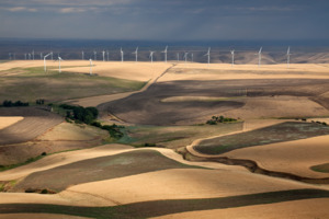
In 2023, most of the electricity used in Washington came from hydroelectric dams (49%). Other sources included natural gas (12%), wind (10%), coal (6.5%), and nuclear (4%). Washington generates the most hydroelectric power of all U.S. states. It accounts for about 25% of the nation's total hydroelectric power. The state ranks third among U.S. states for the percentage of energy from all renewable sources.
Government and Politics
State Government Structure

Washington's government has three main parts. The executive branch is led by a governor, who is elected for a four-year term. Other important statewide officials include the Lieutenant Governor, Secretary of State, and Attorney General.
The bicameral Washington State Legislature is the state's law-making branch. It has a House of Representatives and an State Senate. The state is divided into 49 districts, each with the same number of people. Each district elects two representatives and one senator. Representatives serve two-year terms, and senators serve four-year terms. There are no limits on how many terms they can serve. The Democratic Party currently has a majority in both the House and Senate.
The Washington Supreme Court is the highest court in the state. It meets in Olympia. Nine justices serve on the court. They are elected statewide or appointed by the governor to fill empty spots.
Federal Representation


Washington has two United States senators and ten representatives in the United States House of Representatives. After the 2010 census, Washington gained one seat in the House. This also gave the state one more electoral vote, bringing its total to 12.
Education in Washington
Schools for Children and Teens
For the 2024–2025 school year, about 1.1 million students were enrolled in elementary and secondary schools in Washington. There were 68,000 teachers in 2023–2024. The state has 295 school districts.
High school juniors and seniors in Washington can use the state's Running Start program. This program, started in 1990, allows students to attend colleges at public expense. They can earn both high school and college credit at the same time. The state has 141 schools that offer dual language programs in 14 languages, mostly Spanish, starting in kindergarten.
The state also has several public high schools that focus on arts. These include Tacoma School of the Arts and the Vancouver School of Arts and Academics. There are also four high schools focused on Science and Math: Delta in the Tri-Cities, SAMI in Tacoma, Raisbeck Aviation High School in Seattle, and Tesla STEM High School in Redmond.
Colleges and Universities
Washington has over 40 institutions for higher education. These include major research universities, technical schools, religious schools, and private career colleges. Some well-known colleges and universities are the University of Washington, Washington State University, Western Washington University, Eastern Washington University, Central Washington University, and Seattle University.
Media in Washington

As of 2022, Washington has 20 daily newspapers and 96 weekly newspapers. These serve local communities. The newspaper with the largest circulation in the state is The Seattle Times. It is also one of the most circulated newspapers in the United States. Other major daily newspapers include The Spokesman-Review in Spokane and The News Tribune in Tacoma.
The Seattle area also has many publications for different ethnic communities. These include the Seattle Chinese Post and Northwest Asian Weekly. Since 2004, Washington has lost 37 local newspapers. Several newspapers have also moved to online-only publication, like Seattle's Post-Intelligencer in 2009.
The state is divided into four main TV and radio markets. The Seattle–Tacoma market is the largest in the Pacific Northwest. As of 2009, Washington had 39 full-power television stations. The state is home to 383 licensed radio stations.
Health Care in Washington
Health Insurance
As of 2017, the top two health insurers were Premera Blue Cross and Kaiser Permanente. For individuals buying their own insurance, Molina Healthcare had the largest share.
The state adopted the Washington Healthplanfinder system in 2014. This happened after the federal Patient Protection and Affordable Care Act was passed. This system is used by about 90% of Washington residents who buy their health insurance directly. The state's Medicaid program, called Washington Apple Health, provides healthcare for people with disabilities or low incomes.
Hospitals and Medical Facilities
Hospitals are located throughout the state. However, many of Washington's most famous medical facilities are in and around Seattle. The Seattle–Tacoma area has six major hospitals. These include Harborview Medical Center, University of Washington Medical Center, and Seattle Children's. As of 2023, the state has over 14,000 hospital beds for patient care in 93 facilities.
Culture and Sports
Sports in Washington
Pickleball, a racquet sport, was invented on Bainbridge Island in 1965. It was named Washington's official state sport in 2022. For three years in a row (2021, 2022, and 2023), pickleball was named the fastest growing sport in the United States.
Major Professional Sports Teams
| Club | Sport | League | Stadium and city |
|---|---|---|---|
| Seattle Kraken | Ice hockey | National Hockey League | Climate Pledge Arena, Seattle |
| Seattle Mariners | Baseball | Major League Baseball | T-Mobile Park, Seattle |
| Seattle Reign FC | Soccer | National Women's Soccer League | Lumen Field, Seattle |
| Seattle Seahawks | Football | National Football League | Lumen Field, Seattle |
| Seattle Sounders FC | Soccer | Major League Soccer | Lumen Field, Seattle |
| Seattle Storm | Basketball | Women's National Basketball Association | Climate Pledge Arena, Seattle |
| PWHL Seattle | Ice hockey | Professional Women's Hockey League | Climate Pledge Arena, Seattle |
College Sports Teams
Washington has many college sports teams that compete in different divisions.
- Washington Huskies
- Washington State Cougars
- Gonzaga Bulldogs
- Seattle Redhawks
- Eastern Washington Eagles
- Central Washington Wildcats
- Saint Martin's Saints
- Seattle Pacific Falcons
- Western Washington Vikings
- Pacific Lutheran Lutes
- Puget Sound Loggers
- Whitman Blues
- Whitworth Pirates
State Symbols and Names
Four ships of the United States Navy have been named USS Washington to honor the state.
The Evergreen State Nickname
The state's nickname, "The Evergreen State," was suggested in 1890. The name became popular because the forests are full of evergreen trees. Also, the abundant rain keeps the plants green all year. The nickname is widely used, even appearing on vehicle license plates. However, it has not been officially adopted. The Evergreen State College in Olympia is named after this nickname.
Official State Symbols
The state song is "Washington, My Home". The state bird is the American goldfinch. The state fruit is the apple, and the state vegetable is the Walla Walla sweet onion. The state dance, adopted in 1979, is the square dance. The state tree is the western hemlock. The state flower is the coast rhododendron. The state fish is the steelhead. The state folk song is "Roll On, Columbia, Roll On" by Woody Guthrie. The unofficial state rock song is "Louie Louie".
Other symbols include:
- State grass: bluebunch wheatgrass
- State insect: green darner dragonfly
- State gem: petrified wood
- State fossil: Columbian mammoth
- State marine mammal: orca
- State soil: Tokul soil
- State land mammal: Olympic marmot
- State seal: Inspired by a portrait of President George Washington
- State sport: pickleball
Images for kids
-
Flag of Washington
-
Seal of Washington
-
Map of Washington in the United States
-
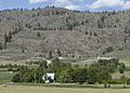
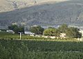
A farm and barren hills near Riverside, in north-central Washington
-
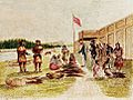
Fur trading at Fort Nez Percés in 1841
-
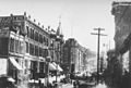
Seattle in 1887
-
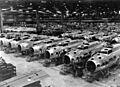
Boeing B-17E Flying Fortress bombers under construction, circa 1942
-
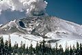
Early eruption of Mt. St. Helens
-
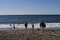
The Pacific coast of Westport
-
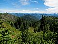
Mount Baker–Snoqualmie National Forest
-

Southeastern Washington
-
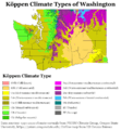
Köppen climate types of Washington, using 1991–2020 climate normals.
-
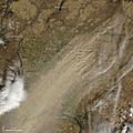
Dryland farming caused a large dust storm in arid parts of Eastern Washington on October 4, 2009. Courtesy: NASA/GSFC, MODIS Rapid Response.
-
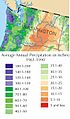
Washington experiences extensive variation in rainfall.
-
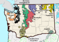
Washington's national forests
-
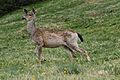
Black-tailed deer graze at Deer Park in Olympic National Park
-
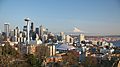
Seattle skyline
-
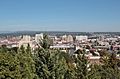
Spokane skyline
-
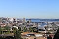
Tacoma skyline
-
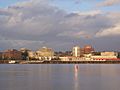
Vancouver skyline
-
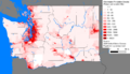
Washington population density map
-
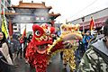
Chinese New Year, Seattle (2011)
-
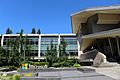
Microsoft Corporation headquarters in Redmond, an Eastside suburb of Seattle
-
Starbucks headquarters, Seattle
-
Azwell, WA, a small community of pickers' cabins and apple orchards
-
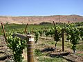
Rattlesnake Hills AVA, one of nineteen American Viticultural Areas in the state
-
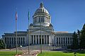
The Washington State Capitol building in Olympia
-
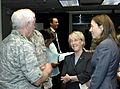
U.S. Senators Patty Murray and Maria Cantwell visit Fairchild Air Force Base.
-

Treemap of the popular vote by county, 2016 presidential election
-
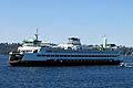
The Washington State Ferries owns the largest ferry system in the United States.
-
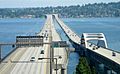
Floating bridges on Lake Washington. These are among the largest of their kind in the world.
-
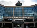
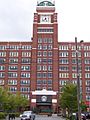
The former offices of the Seattle Post-Intelligencer, a major daily newspaper


.jpg)
.jpg)

See also
 In Spanish: Washington (estado) para niños
