Kettle River Range facts for kids
Quick facts for kids Kettle River Range |
|
|---|---|

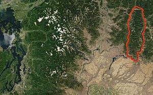
NASA satellite image of north central Washington state and southern British Columbia with the Kettle River Range outlined in red
(photo: MODIS Jacques Descloitres, 2001) |
|
| Highest point | |
| Peak | Copper Butte (U.S.) |
| Elevation | 2,177 m (7,142 ft) |
| Dimensions | |
| Area | 2,700 sq mi (7,000 km2) |
| Geography | |
| Country | Canada/United States |
| State/Province | Boundary Country: Washington & British Columbia |
| Range coordinates | 49°0′N 118°25′W / 49.000°N 118.417°W |
| Parent range | Monashee Mountains, parent range: Columbia Mountains |
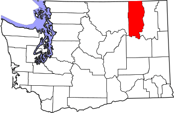
The Kettle River Range, also known as the Kettle Range, is a group of mountains. It's the most southern part of the Monashee Mountains. You can find it in southeastern British Columbia, Canada, and in Ferry County, Washington, in the United States. A large part of the northern mountains is protected by the Colville National Forest. The southern part is on the Colville Indian Reservation. The tallest mountain here is Copper Butte. It stands about 2,177 metres (7,142 ft) high. Washington State Route 20 crosses the range at Sherman Pass.
Contents
Exploring the Kettle River Range
The Kettle River Range covers a huge area of about 2,700 square miles (7,000 km2). It is a smaller part of the Monashee Mountains. These mountains are part of the larger Columbia Mountains.
Where is the Kettle River Range?
The range runs from north to south. On its east side, you'll find the Kettle River and the Columbia River. On the west side, it's bordered by the Kettle River, the Curlew Valley, and the San Poil River.
The mountains start right at the Canada–US border. This is near Grand Forks, British Columbia. They stretch about 110 miles (177 km) south. The range ends where the Columbia River bends. This area is also near Lake Roosevelt. This lake was formed by the Grand Coulee Dam. To the west of the range are the Okanogan Highlands. To the east are the Selkirk Mountains.
Sherman Pass Scenic Byway
The Sherman Pass Scenic Byway is a road that goes through the middle of the Kettle River Range. It runs for about 40 miles (64 km) east from the town of Republic, Washington. The highest point on this road is Sherman Pass. It is 5,575 feet (1,699 m) high. This is the highest mountain pass in Washington state that is open all year. The road is named after American Civil War General William Tecumseh Sherman. He traveled through this area in 1883.
History of the Kettle River Range
The Kettle River Range has a rich history, especially with mining and wildfires.
Gold Mining in the Mountains
Between 1896 and 1959, people found a lot of gold in the Kettle River Range. Prospectors and Chinese miners dug up over 839,000 ounces of gold. Most of this gold came from the Republic District. Smaller amounts, about 6,000 ounces, came from the Danville and Columbia River Districts. Gold was also found in river deposits near Keller.
During this time, 164 lode mines were active in Ferry County. In these mines, workers used pickaxes and shovels to dig out thick mineral veins. There were also 35 placer mines. In placer mining, minerals that were exposed by erosion were collected from rivers and loose soil. From 1904 to 1928, the Kettle River Range produced the most gold in Washington state. Besides gold, miners also found silver, copper, lead, zinc, platinum, nickel, cobalt, tungsten, iron, and iron pyrite (also known as "fool’s gold").
Wildfires in the Range
In 1988, a large fire called the White Mountain wildfire happened. It burned about 21,000 acres of trees in the southern part of the range. This included most of White Mountain, Edds Mountain, Bald Mountain, and Snow Peak. The State of Washington has built special sites along the roads. These sites explain the damage caused by the fire.
Another big fire event was the Kettle Complex fires in 2015. This group of three fires—the Stickpin, Renner, and Graves Mountain fires—burned south of the Canada–US border. They burned west of Highway 395, north of State Route 20, and east of Highway 21. These fires burned an estimated 73,392 acres.
Recreation Today
Today, the Kettle River Range is a popular place for outdoor activities all year round. People enjoy hiking, sport and aided climbing, snowshoeing, and cross-country skiing. The Kettle Crest National Recreation Trail runs along the main ridge of the mountains. You can get onto this trail from the Kettle Crest Trailhead in the north. Or, you can use the Deer Creek Summit South/Sno-Park Trailhead in the south.
Tallest Mountains in the Kettle River Range
Here are some of the major peaks in the Kettle River Range:
- Copper Butte, 7,142 feet (2,177 m), the highest mountain in the Kettle River Range
- Snow Peak, 7,103 feet (2,165 m), 48°34′55″N 118°28′56″W / 48.58194°N 118.48222°W
- Scar Mountain, 7,046 feet (2,148 m), 48°40′52″N 118°27′36″W / 48.68111°N 118.46000°W
- Wapaloosie Mountain, 7,018 feet (2,139 m), 48°39′52″N 118°27′47″W / 48.66444°N 118.46306°W
- Sherman Peak, 7,011 feet (2,137 m), 48°35′48″N 118°28′39″W / 48.59667°N 118.47750°W
- Bald Mountain, 6,940 feet (2,115 m), 48°33′33″N 118°30′09″W / 48.55917°N 118.50250°W
- White Mountain, 6,923 feet (2,110 m), 48°30′41″N 118°27′12″W / 48.51139°N 118.45333°W
- Columbia Mountain, 6,782 feet (2,067 m), 48°37′13″N 118°28′55″W / 48.62028°N 118.48194°W
- Midnight Mountain, 6,660 feet (2,030 m), 48°35′48″N 118°28′39″W / 48.59667°N 118.47750°W
- King Mountain, 6,634 feet (2,022 m), 48°40′36″N 118°24′11″W / 48.67667°N 118.40306°W
- Edds Mountain, 6,540 feet (1,993 m), 48°33′27″N 118°32′16″W / 48.55750°N 118.53778°W
 | John T. Biggers |
 | Thomas Blackshear |
 | Mark Bradford |
 | Beverly Buchanan |


