
Republic, Washington facts for kids
Quick facts for kids
Republic, Washington
|
|
|---|---|
 |
|

Location of Republic, Washington
|
|
| Country | United States |
| State | Washington |
| County | Ferry |
| Area | |
| • Total | 1.42 sq mi (3.68 km2) |
| • Land | 1.42 sq mi (3.68 km2) |
| • Water | 0.00 sq mi (0.00 km2) |
| Elevation | 2,569 ft (783 m) |
| Population
(2020)
|
|
| • Total | 992 |
| • Density | 698.6/sq mi (269.6/km2) |
| Time zone | UTC−08:00 (Pacific (PST)) |
| • Summer (DST) | UTC−07:00 (PDT) |
| ZIP Code |
99166
|
| Area code | 509 |
| FIPS code | 53-57850 |
| GNIS feature ID | 1525005 |
| Website | City of Republic |
Republic is a small city in Ferry County, Washington, United States. In 2020, about 992 people lived there. It is the main town, or county seat, of Ferry County. Republic was once a very busy mining town, especially for gold. It was also known for its special railway line called the "Hot Air Line."
Contents
History of Republic

Gold Mining Begins
Republic was started by people looking for gold in the late 1800s. The first gold claims were made in March 1896, after a part of the Colville Indian Reservation was opened up. On March 5, 1896, Thomas Ryan and Philip Creasor found gold and claimed the land that would become the Republic Mine. This mine later produced the most gold in the county. The area was officially named the Republic Mining District in April 1896.
Early on, special mills were built to process the gold ore. Some of the best ore was even taken 80 kilometers (50 miles) away to another town for processing. Over time, different methods were used to get gold from the ore, but it was often tricky to get all the gold out.
The Republic mine and its mill closed in 1901 because it was too expensive to process the ore and not enough gold was being found. But when railroads arrived in 1902, mining became profitable again. For several years, ore was sent to Canada to be processed. By 1909, Republic was the most important mining town in the area, with about 1,500 people.
From Eureka to Republic
In July 1897, Philip Creasor built a hotel in the new town, which was first called Eureka. However, there was already another town named Eureka in Washington. So, on April 29, 1898, the town was officially named Republic. On May 8, 1900, the town became an official city, and J.J. Sullivan was chosen as its first mayor.
Two different train lines came to Republic. One was part of the Great Northern Railway, and the other was a local line called the Republic and Kettle Valley Railway. People often called this local line the "Hot Air Line." In the summer of 1900, Charles E. Anderson opened Anderson's Grocery, which is still open today!
The "Hot Air Line" Railway

The "Hot Air Line" was a special railway that connected Republic to other towns like Grand Forks and Lynch Creek in British Columbia. It started running in 1902. This train line helped move goods and people, making it easier for the mining industry to grow. It was built on higher ground because another railway already had land lower down.
Fun Times in Early Republic
In the early 1900s, Republic had its own Baseball team! They played against teams from other nearby cities. The town also had a brass band that played music at events, like the Fourth of July celebrations. In 1913, the Republic Theater got a new owner who fixed it up, showing that entertainment was important to the town.
The 1983 Republic Hotel Fire
On December 4, 1983, a big fire started in Republic. It began in the Republic Hotel and cafe and quickly spread. The fire burned for over two hours and destroyed the hotel, a state liquor store, the local newspaper office, and another empty building. Firefighters from several nearby towns came to help put out the blaze.
Republic Today
Republic's importance as a gold mining town slowly changed as people moved away. Between 1900 and 1910, the town's population dropped by more than half. However, mining is still a big part of Republic's history and economy. Gold is still found in the mountains around the town. As of 2022, about 8 million ounces of gold have been found in northern Ferry County.
Today, Republic has about 1,100 people. The town is supported by local farmers, ranchers, miners, and tourists. Many visitors come to enjoy a quieter, slower pace of life.
Geography and Climate

Republic is located in a valley near the Sanpoil River. It sits on a low part of Klondike Mountain. The valley is surrounded by hills called the Okanagan Highlands to the west and the Kettle River Range to the east. The city covers about 3.68 square kilometers (1.42 square miles) of land.
Weather in Republic

Republic has a climate with cold winters and warm summers. It gets a fair amount of rain and snow throughout the year. Summers can be a bit drier, but there's often more rain in spring.
| Climate data for Republic, Washington, 1991–2020 normals: 2555ft (779m) | |||||||||||||
|---|---|---|---|---|---|---|---|---|---|---|---|---|---|
| Month | Jan | Feb | Mar | Apr | May | Jun | Jul | Aug | Sep | Oct | Nov | Dec | Year |
| Record high °F (°C) | 53 (12) |
58 (14) |
77 (25) |
89 (32) |
96 (36) |
109 (43) |
108 (42) |
105 (41) |
98 (37) |
87 (31) |
65 (18) |
61 (16) |
109 (43) |
| Mean daily maximum °F (°C) | 31.1 (−0.5) |
38.2 (3.4) |
48.6 (9.2) |
58.2 (14.6) |
67.9 (19.9) |
73.9 (23.3) |
84.1 (28.9) |
84.0 (28.9) |
74.1 (23.4) |
56.9 (13.8) |
39.7 (4.3) |
30.2 (−1.0) |
57.2 (14.0) |
| Daily mean °F (°C) | 23.6 (−4.7) |
27.9 (−2.3) |
36.3 (2.4) |
43.8 (6.6) |
52.5 (11.4) |
58.1 (14.5) |
65.3 (18.5) |
64.6 (18.1) |
56.0 (13.3) |
43.2 (6.2) |
31.5 (−0.3) |
23.1 (−4.9) |
43.8 (6.6) |
| Mean daily minimum °F (°C) | 16.1 (−8.8) |
17.7 (−7.9) |
23.9 (−4.5) |
29.3 (−1.5) |
37.0 (2.8) |
42.4 (5.8) |
46.5 (8.1) |
45.2 (7.3) |
37.9 (3.3) |
29.4 (−1.4) |
23.3 (−4.8) |
16.0 (−8.9) |
30.4 (−0.9) |
| Record low °F (°C) | −33 (−36) |
−34 (−37) |
−19 (−28) |
3 (−16) |
11 (−12) |
25 (−4) |
29 (−2) |
27 (−3) |
14 (−10) |
−5 (−21) |
−20 (−29) |
−38 (−39) |
−38 (−39) |
| Average precipitation inches (mm) | 1.62 (41) |
1.34 (34) |
1.54 (39) |
1.38 (35) |
2.06 (52) |
2.17 (55) |
1.16 (29) |
0.64 (16) |
0.87 (22) |
1.25 (32) |
1.86 (47) |
2.19 (56) |
18.08 (458) |
| Average snowfall inches (cm) | 13.1 (33) |
6.6 (17) |
3.3 (8.4) |
0.5 (1.3) |
0.0 (0.0) |
0.0 (0.0) |
0.0 (0.0) |
0.0 (0.0) |
0.0 (0.0) |
0.4 (1.0) |
7.7 (20) |
20.9 (53) |
52.5 (133.7) |
| Average precipitation days | 11.0 | 8.3 | 9.3 | 9.1 | 10.5 | 10.3 | 5.6 | 4.3 | 5.3 | 8.3 | 11.4 | 12.4 | 105.8 |
| Average snowy days | 8.5 | 4.0 | 2.4 | 0.4 | 0.0 | 0.0 | 0.0 | 0.0 | 0.0 | 0.2 | 4.4 | 9.8 | 29.7 |
| Source: NOAA | |||||||||||||
During hot, dry summers, smoke from wildfires in the region can sometimes cover the town. Several wildfires have burned near Republic in the past, including the 2001 Mount Leona Fire.
Population and People
| Historical population | |||
|---|---|---|---|
| Census | Pop. | %± | |
| 1900 | 2,050 | — | |
| 1910 | 999 | −51.3% | |
| 1920 | 781 | −21.8% | |
| 1930 | 710 | −9.1% | |
| 1940 | 922 | 29.9% | |
| 1950 | 895 | −2.9% | |
| 1960 | 1,064 | 18.9% | |
| 1970 | 862 | −19.0% | |
| 1980 | 1,018 | 18.1% | |
| 1990 | 940 | −7.7% | |
| 2000 | 954 | 1.5% | |
| 2010 | 1,073 | 12.5% | |
| 2020 | 992 | −7.5% | |
| U.S. Decennial Census 2020 Census |
|||
Who Lives in Republic?
In 2020, Republic had 992 people living there. This was a small decrease from 2010, when 1,073 people lived in the city. Most people in Republic are White (about 80%). There are also smaller groups of Native American, Asian, and African American residents. About 3.7% of the population identifies as being from other races, and 1.7% are from two or more races. About 2.7% of the population is Hispanic or Latino.
In 2010, the average age in Republic was about 45 years old. About 19.7% of residents were under 18, and 20.7% were 65 or older.
Economy and Jobs
Republic has many businesses along Clark Avenue, its main street. Some of these businesses have been around for a long time, like Anderson's Grocery, which opened in 1900, and the Republic Drug Store, which opened in 1902.
The Ferry County Memorial Hospital is the biggest employer in the county. Since Republic is the county seat, many city, county, and state jobs are located there.
Republic is also a popular spot for tourists. Curlew Lake, which is 7 kilometers (4.3 miles) long, is northeast of Republic and is great for fishing and boating in the summer. Swan Lake, a smaller mountain lake, is also a favorite spot for locals and visitors. The city is surrounded by the Colville National Forest, offering lots of outdoor activities.
Arts and Culture

Republic celebrates its history of mining and logging every year during Prospector's Days. This event happens on the second weekend in June. People can try gold panning, watch old-west gunfights, and compete in mining and logging challenges.
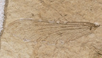
The Stonerose Interpretive Center and Fossil Site is a famous place in Republic. It has amazing Eocene fossils that are about 49 million years old! These fossils were found in an ancient lake bed. Many extinct plants and animals found here have been named after Republic, like a type of maple tree called Acer republicense and a damselfly called Republica weatbrooki.
At the Ferry County Fairgrounds, about 3 miles east of town, you can find the Ferry County Carousel. This carousel was built a long time ago, between 1895 and 1900.
Education
The Republic School District runs four public schools in the town. In the 2022–23 school year, about 278 students attended these schools. The district serves students from Republic south to the Colville Reservation and north to Curlew Lake.
Parks and Recreation
Republic has a cool skate park that was finished in 2024. It was designed with a main bowl shaped like a Florissantia flower, which is a type of fossil flower found in the area. The park is located near the Republic schools and the Golden Tiger Trail. Many people, including the Washington State Governor and Pearl Jam bassist Jeff Ament, supported building this park.
See also
 In Spanish: Republic (Washington) para niños
