Ferry County, Washington facts for kids
Quick facts for kids
Ferry County
|
|
|---|---|

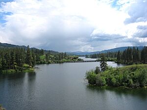
Ferry County Rail Trail trestle at Curlew Lake
|
|

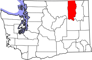
Location within the U.S. state of Washington
|
|
 Washington's location within the U.S. |
|
| Country | |
| State | |
| Founded | February 21, 1899 |
| Named for | Elisha P. Ferry |
| Seat | Republic |
| Largest city | Republic |
| Area | |
| • Total | 2,257 sq mi (5,850 km2) |
| • Land | 2,203 sq mi (5,710 km2) |
| • Water | 54 sq mi (140 km2) 2.4%% |
| Population
(2020)
|
|
| • Total | 7,178 |
| • Estimate
(2023)
|
7,497 |
| • Density | 3.5/sq mi (1.4/km2) |
| Time zone | UTC−8 (Pacific) |
| • Summer (DST) | UTC−7 (PDT) |
| Congressional district | 5th |
Ferry County is a county located in the northern part of Washington state. It sits right on the border with Canada. In 2020, about 7,178 people lived here, making it one of the least populated counties in Washington. The main town and county seat is Republic. Ferry County was created in February 1899 from parts of Stevens County. It is named after Elisha P. Ferry, who was the very first governor of Washington state.
Contents
How Ferry County Got Its Name
When the state government first planned to create this county, they thought about naming it "Eureka County." However, while they were discussing the new county, they decided to change the name to "Ferry County." This was done to honor Elisha P. Ferry, who was the last governor of the Washington Territory and then became the first governor of Washington State. This naming also connected it to Stevens County, which was named after the first governor of the Washington Territory.
A Look at Ferry County's History
The area that is now Ferry County has a long history. Back in 1863, Stevens County was first created. It covered a huge area, from the Columbia River all the way west to the Cascade Mountains. Over the years, this large county was divided into smaller parts.
On February 18, 1899, the western part of Stevens County was separated to form Ferry County. This is how our county came to be!
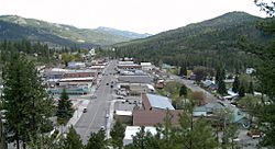
The town of Republic is the county's main town and where the local government offices are. Gold miners founded Republic in the late 1800s, and it officially became a town in 1900.
The first courthouse in Ferry County was made of wood and sadly burned down in 1934. A new courthouse, built from concrete and stucco, replaced it.
In August 2001, several large wildfires started in eastern Washington due to lightning storms. One of these was the Mount Leona Fire. It burned for many weeks and covered over 6,000 acres near Curlew Lake.
Geography of Ferry County
Ferry County has some interesting neighbors! To the north, it shares a border with the Kootenay Boundary Regional District, British Columbia in Canada. To the west is Okanogan County. The southern border is along the middle of the Columbia River, and to the east is Stevens County, also along the Columbia River and then the Kettle River.
The county covers about 2,257 square miles. Most of this area, about 2,203 square miles, is land, and 54 square miles (2.4%) is water. A big part of Ferry County is covered by the rugged Kettle River Range mountains. This mountain range stretches from the Canadian border down to the Columbia River. There's also a narrow strip on the western side that is part of the Okanogan Highland. Except for the town of Republic, the county doesn't have many people living in it.
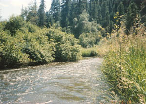
Ferry County has three main river systems. The huge Columbia River forms the southern and most of the eastern border. The Kettle River flows into the county from Canada, then turns north to go back into Canada, and then swings south again to join the Columbia River. The southern and central parts of the county are drained by the Sanpoil River, which flows south and joins the Columbia River.
You can also find several fun lakes in the county, like Swan Lake, Ferry Lake, Fish Lake, and Long Lake, which are great for recreation.
Kettle River Peaks
The tallest mountains in Ferry County are found in the Kettle River Range. These peaks are part of either the Colville National Forest or the Colville Indian Reservation.
Highway 20 crosses the Kettle River Range at Sherman Pass. At 5,575 feet, it's the highest mountain pass in Washington that stays open all year! The Pacific Northwest National Scenic Trail also goes through the county, offering amazing views.
- Copper Butte, highest point: 7,140 feet
- Snow Peak, 7,103 feet
- Scar Mountain, 7,046 feet
- Wapaloosie Mountain, 7,018 feet
- Sherman Peak, 7,011 feet
- Bald Mountain, 6,940 feet
- White Mountain, 6,923 feet
- Columbia Mountain, 6,782 feet
- Midnight Mountain, 6,660 feet
- King Mountain, 6,634 feet
- Edds Mountain, 6,540 feet
Ferry County's Economy
Ferry County's economy relies on a few key things. Because it borders Canada and the Columbia River, and a large part of it is covered by the Colville Indian Reservation and Colville National Forest, only a small portion of the land can be used for taxes.
The main industries here are getting timber from forests and mining for minerals.
Ferry County is also a great place for outdoor activities and visitors. Its beautiful mountains and climate make it a popular spot for tourism. Washington State Highway 20, which is a National Scenic Highway, crosses the county from east to west. This highway includes the state's highest pass that you can drive through all year.
In Republic, you can visit the Stonerose Interpretive Center and Fossil Site. Here, you can see and learn about very old fossils from a lake that existed millions of years ago. Anderson's Grocery is a historic store in northern Ferry County that has been open since 1900!
Population and People
| Historical population | |||
|---|---|---|---|
| Census | Pop. | %± | |
| 1900 | 4,562 | — | |
| 1910 | 4,800 | 5.2% | |
| 1920 | 5,143 | 7.1% | |
| 1930 | 4,292 | −16.5% | |
| 1940 | 4,701 | 9.5% | |
| 1950 | 4,096 | −12.9% | |
| 1960 | 3,889 | −5.1% | |
| 1970 | 3,655 | −6.0% | |
| 1980 | 5,811 | 59.0% | |
| 1990 | 6,295 | 8.3% | |
| 2000 | 7,260 | 15.3% | |
| 2010 | 7,551 | 4.0% | |
| 2020 | 7,178 | −4.9% | |
| 2023 (est.) | 7,497 | −0.7% | |
| U.S. Decennial Census 1790–1960 1900–1990 1990–2000 2010–2020 |
|||
According to the 2010 census, there were 7,551 people living in Ferry County. There were about 3,190 households.
Most of the people living in the county were white (76.3%). A significant number were also American Indian (16.7%). Other groups included Asian, Black, Pacific Islander, and people from two or more races. About 3.4% of the population was of Hispanic or Latino origin.
The average age of people in Ferry County was about 47.3 years old.
Towns and Places
City
- Republic (This is the main town and where the county government is located.)
Census-designated places
These are areas that are like towns but are not officially incorporated as cities.
Other unincorporated communities
These are smaller communities that are not officially part of a city or a census-designated place.
Famous People from Ferry County
- Alex N. Dragnich (1912-2009) - A political scientist who studied how governments work.
- Stella Leach (1918-2010) - A nurse and activist who worked to help others.
See also
 In Spanish: Condado de Ferry para niños
 | Sharif Bey |
 | Hale Woodruff |
 | Richmond Barthé |
 | Purvis Young |


