Kettle River (Columbia River tributary) facts for kids
Quick facts for kids Kettle River |
|
|---|---|

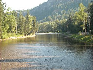
Kettle River from railway trestle
|
|

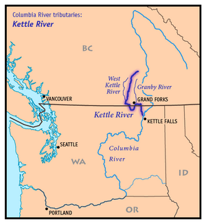
Map of the Kettle River and its two main tributaries
|
|
| Country | United States, Canada |
| State | Washington |
| Province | British Columbia |
| City | Grand Forks, BC, Kettle Falls, WA |
| Physical characteristics | |
| Main source | Holmes Lake British Columbia, Canada 50°06′55″N 118°18′43″W / 50.11528°N 118.31194°W 50°06′55″N 118°18′43″W / 50.11528°N 118.31194°W |
| River mouth | Columbia River Franklin D. Roosevelt Lake, Washington (state) 1,500 ft (460 m) 48°40′22″N 118°6′50″W / 48.67278°N 118.11389°W |
| Length | 175 mi (282 km) |
| Basin features | |
| Basin size | 4,200 sq mi (11,000 km2) |
| Tributaries |
|
The Kettle River is a long river, about 281-kilometre (175 mi) (175 miles) in length. It's a branch of the mighty Columbia River. The area of land that drains into the Kettle River, called its drainage basin, covers about 10,877-square-kilometre (4,200 sq mi) (4,200 square miles). Most of this area is in southern British Columbia, Canada, and a smaller part is in northeastern Washington, USA.
What's in a Name?
The Kettle River has an interesting name! The local Indigenous people, the Okanagan, called it nxʷyaʔłpítkʷ (pronounced Ne-hoi-al-pit-kwu). Even though British officials knew this name, "Kettle River" became popular around 1860. The most likely reason for the name comes from a place called Kettle Falls. Early explorers called these falls "La Chaudiére," which means "The Boiler" in French. This was because the water looked like it was bubbling and boiling. Another idea is that the name comes from round holes in the rocks. These holes were shaped like big cooking pots, or "kettles," carved out by the water over time.
Where Does the Kettle River Flow?
The Kettle River starts its journey at Holmes Lake in the Monashee Mountains of British Columbia. From there, it flows south towards a town called Midway, British Columbia. Many smaller streams, called tributaries, join the Kettle River along the way. The West Kettle River is one of the most important ones. After Midway, the river makes a big loop south. It crosses the Canada-US border into the United States, flowing through Ferry County, Washington. Then, it turns north and flows back into Canada. It passes by Grand Forks, British Columbia, where the Granby River adds its water to the Kettle. The river then flows east for about 10 miles (16 km) (6 miles). It turns south again, just below Christina Lake, and enters the United States once more. Finally, it flows south, forming part of the border between Ferry and Stevens counties. The Kettle River then joins the Columbia River near Kettle Falls, Washington. At this point, the Columbia River is a large lake called Lake Roosevelt. This lake was formed by the Grand Coulee Dam. The Kettle River flows into Lake Roosevelt at a spot known as the Columbia's river mile 706. What makes the Kettle River special is that it has no dams on it. This means its water flows freely all the time, which is rare for rivers in the Pacific Northwest!
Natural History and Fish
The Kettle River used to be home to many types of fish, including salmon. Salmon are anadromous fish, which means they live in the ocean but swim upstream into rivers to lay their eggs. However, the building of large dams like the Grand Coulee Dam and the Chief Joseph Dam on the Columbia River changed things. These dams blocked the path for fish to swim up the Columbia and its branches, including the Kettle River. Also, the big lake created by the Grand Coulee Dam, Lake Roosevelt, covered up many traditional fishing spots. This included Kettle Falls, which was very close to where the Kettle River joins the Columbia.
 | May Edward Chinn |
 | Rebecca Cole |
 | Alexa Canady |
 | Dorothy Lavinia Brown |


