Stevens County, Washington facts for kids
Quick facts for kids
Stevens County
|
||
|---|---|---|

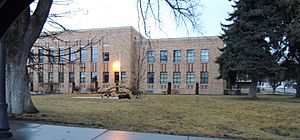
Stevens County Courthouse in Colville
|
||
|
||

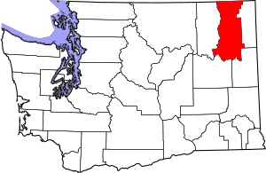
Location within the U.S. state of Washington
|
||
 Washington's location within the U.S. |
||
| Country | ||
| State | ||
| Founded | January 20, 1863 | |
| Named for | Isaac Stevens | |
| Seat | Colville | |
| Largest city | Colville | |
| Area | ||
| • Total | 2,541 sq mi (6,580 km2) | |
| • Land | 2,478 sq mi (6,420 km2) | |
| • Water | 63 sq mi (160 km2) 2.5%% | |
| Population
(2020)
|
||
| • Total | 46,445 | |
| • Estimate
(2023)
|
48,837 |
|
| • Density | 18/sq mi (7/km2) | |
| Time zone | UTC−8 (Pacific) | |
| • Summer (DST) | UTC−7 (PDT) | |
| Congressional district | 5th | |
Stevens County is a special area in the U.S. state of Washington. It is located right along the border with Canada. In 2020, about 46,445 people lived there. By July 2023, the number of people was estimated to be 48,837.
The main town and biggest city in Stevens County is Colville. This is where the county's government offices are located. Stevens County was created in 1863. It was named after Isaac Stevens, who was the very first governor of the Washington Territory. A "territory" is like a state before it becomes a full state.
Stevens County is also part of the larger Spokane-Spokane Valley region. A "metropolitan area" means a big city and all the smaller towns and areas around it. Most of the Spokane Indian Reservation is found within Stevens County.
Contents
Where is Stevens County Located?
Stevens County is in the northeastern part of Washington state. It covers a total area of about 2,541 square miles. Most of this area, about 2,478 square miles, is land. The remaining 63 square miles, which is about 2.5% of the total, is water.
Important Waterways
- Columbia River: A very large and important river flows through or near Stevens County.
Neighboring Areas
Stevens County shares its borders with several other counties and even another country:
- To the east: Pend Oreille County
- To the southeast: Spokane County
- To the southwest: Lincoln County
- To the west: Ferry County
- To the northeast: Kootenay Boundary Regional District, British Columbia (in Canada)
- To the north: Regional District of Central Kootenay, British Columbia (in Canada)
Protected Natural Areas
Parts of these special national areas are found within Stevens County:
- Pacific Northwest National Scenic Trail: A long trail for hiking and enjoying nature.
- Colville National Forest: A large forest managed by the government.
- Kaniksu National Forest: Another big national forest.
- Lake Roosevelt National Recreation Area: An area around a lake for fun activities.
- Little Pend Oreille National Wildlife Refuge: A place set aside to protect wild animals.
Who Lives in Stevens County?
The number of people living in Stevens County has changed a lot over the years. Here's how the population has grown:
| Historical population | |||
|---|---|---|---|
| Census | Pop. | %± | |
| 1860 | 996 | — | |
| 1870 | 734 | −26.3% | |
| 1880 | 1,245 | 69.6% | |
| 1890 | 4,341 | 248.7% | |
| 1900 | 10,543 | 142.9% | |
| 1910 | 25,297 | 139.9% | |
| 1920 | 21,605 | −14.6% | |
| 1930 | 18,550 | −14.1% | |
| 1940 | 19,275 | 3.9% | |
| 1950 | 18,580 | −3.6% | |
| 1960 | 17,884 | −3.7% | |
| 1970 | 17,405 | −2.7% | |
| 1980 | 28,979 | 66.5% | |
| 1990 | 30,948 | 6.8% | |
| 2000 | 40,066 | 29.5% | |
| 2010 | 43,531 | 8.6% | |
| 2020 | 46,445 | 6.7% | |
| 2023 (est.) | 48,837 | 12.2% | |
| U.S. Decennial Census 1790–1960 1900–1990 1990–2000 2010–2020 |
|||
Population Details from 2010
In 2010, there were about 17.6 people living in each square mile of the county. There were also about 21,156 homes.
Most people in Stevens County are White (88.9%). Other groups include Native American (1.5%), Asian (1.5%), and Black or African American (0.6%). About 2.7% of the people were of Hispanic or Latino background. Many people have family roots from Germany, Ireland, or England.
About 29.6% of homes had children under 18 living there. More than half of the homes (56.3%) were married couples. The average age of people in the county was 45 years old.
The average yearly income for a household was about $42,845. For families, it was about $51,544. About 15.1% of all people, and 21.1% of those under 18, lived below the poverty line.
Towns and Cities in Stevens County
Stevens County has several different types of communities.
Cities
These are larger towns with their own local governments:
- Chewelah
- Colville (This is the county seat, where the main government offices are.)
- Kettle Falls
Towns
These are smaller than cities but still have their own governments:
Census-Designated Places (CDPs)
These are areas that are like towns but don't have their own local government. The government counts their population for the census:
Unincorporated Communities
These are small places that are not officially cities or towns. They are part of the larger county area:
See also
 In Spanish: Condado de Stevens (Washington) para niños
 | James Van Der Zee |
 | Alma Thomas |
 | Ellis Wilson |
 | Margaret Taylor-Burroughs |


