Chewelah, Washington facts for kids
Quick facts for kids
Chewelah
|
|
|---|---|
| Chewelah, Washington | |

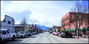
Main Avenue in Downtown Chewelah, 2018
|
|

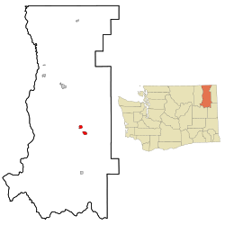
Location of Chewelah, Washington
|
|
| Country | United States |
| State | Washington |
| County | Stevens |
| Area | |
| • Total | 2.95 sq mi (7.65 km2) |
| • Land | 2.95 sq mi (7.65 km2) |
| • Water | 0.00 sq mi (0.00 km2) |
| Elevation | 1,673 ft (510 m) |
| Population
(2020)
|
|
| • Total | 2,470 |
| • Density | 837.3/sq mi (322.9/km2) |
| Time zone | UTC-8 (Pacific (PST)) |
| • Summer (DST) | UTC-7 (PDT) |
| ZIP code |
99109
|
| Area code | 509 |
| FIPS code | 53-12140 |
| GNIS feature ID | 2409444 |
Chewelah (pronounced chə-WEE-lə) is a city in Stevens County, Washington, United States. It's located about 45 miles (72 km) northwest of Spokane. In 2020, about 2,470 people lived there.
Contents
History of Chewelah
How Chewelah Got Its Name
The name Chewelah comes from a word in the Kalispel language. The word, sč̓ewíleʔ, means 'watersnake' or 'gartersnake'. Before European settlers arrived, the area was home to a group of Kalispel people. They were known as the slet̓éw̓si, which means "valley people."
Early Days and Settlement
The area was first called Fool's Prairie. This name came from an indigenous Kalispel person who left his own tribe. For a short time in 1872, Chewelah and the surrounding Colville River Valley were part of the Colville Indian Reservation. However, the reservation's size was soon made smaller. Today, the Chewelah Band of Indians is part of the Spokane Tribe.
In 1859, Thomas and Mary Brown moved to Fool's Prairie. Thomas Brown was given permission to open a post office called Chewelah in 1872. The name Chewelah first appeared in official records that same year. The city was officially formed on January 26, 1903.
Chewelah's Firsts
Chewelah was a place of many "firsts" in Stevens County:
- The first Protestant Congregational Church was built in 1891.
- The first school opened in 1869.
- The Spokane Falls and Northern Railway arrived in 1889, connecting the town to other places.
- A Catholic church was established in 1885.
- The first county newspaper started in July 1885.
Mining and Growth
Chewelah began as a farming community in the 1870s. People also looked for valuable minerals nearby as early as 1842. The town was officially mapped out in 1884. It became known as a busy mining town. The first mines for lead and silver opened around 1886.
The town's newspaper, The Independent, was started in 1903 by William Hunter Brownlow. His four sons helped him produce a weekly eight-page newspaper. It has been published ever since.
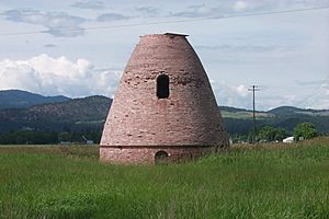
By 1905, Chewelah had 650 residents. Soon, many successful mines for copper, silver, lead, and some gold were active. The most important mineral mined in Chewelah was magnesite. By 1916, Chewelah's magnesite plant was the largest in the country. At its peak, it was the largest in the world, shipping about 700 tons every day. During World War I, about 800 people worked at the plant making special bricks that could handle very high temperatures.
Changes Over Time
By 1920, Chewelah's population grew to 1,600 people. The town continued to do well until the late 1960s. In 1968, the magnesite plant closed. This happened because other countries, like Japan, could produce magnesite more cheaply. Also, the way steel was made changed.
Even though this was a big change, Chewelah managed to adapt. It was no longer a "one-company town." Today, Chewelah has thousands of residents. It combines its history with new developments. Farming, ranching, and dairy farming are still important. Chewelah also has a ski area and a golf course, among other businesses.
In June 2019, Chewelah became the second "Creative District" in Washington state. This means it's recognized for its focus on arts and culture.
Geography and Climate
Where is Chewelah?
Chewelah covers about 2.98 square miles (7.65 square kilometers) of land.
Chewelah's Weather
Chewelah has a climate with big differences in temperature between seasons. Summers are warm to hot, and sometimes humid. Winters are cold, and can be very cold. This type of weather is called a humid continental climate.
| Climate data for Chewelah | |||||||||||||
|---|---|---|---|---|---|---|---|---|---|---|---|---|---|
| Month | Jan | Feb | Mar | Apr | May | Jun | Jul | Aug | Sep | Oct | Nov | Dec | Year |
| Record high °F (°C) | 57 (14) |
62 (17) |
75 (24) |
91 (33) |
100 (38) |
106 (41) |
107 (42) |
110 (43) |
104 (40) |
92 (33) |
69 (21) |
58 (14) |
110 (43) |
| Mean daily maximum °F (°C) | 33.9 (1.1) |
40.8 (4.9) |
49.2 (9.6) |
61.6 (16.4) |
69.4 (20.8) |
76.2 (24.6) |
86.6 (30.3) |
83.9 (28.8) |
75.5 (24.2) |
61.5 (16.4) |
45.5 (7.5) |
36.9 (2.7) |
60.1 (15.6) |
| Mean daily minimum °F (°C) | 19.8 (−6.8) |
23.6 (−4.7) |
27.8 (−2.3) |
33.9 (1.1) |
40.3 (4.6) |
45.7 (7.6) |
51.9 (11.1) |
50.7 (10.4) |
45.5 (7.5) |
36 (2) |
28.3 (−2.1) |
23.8 (−4.6) |
35.6 (2.0) |
| Record low °F (°C) | −38 (−39) |
−38 (−39) |
−12 (−24) |
12 (−11) |
16 (−9) |
26 (−3) |
31 (−1) |
28 (−2) |
12 (−11) |
2 (−17) |
−19 (−28) |
−33 (−36) |
−38 (−39) |
| Average precipitation inches (mm) | 2.3 (58) |
1.74 (44) |
1.83 (46) |
1.44 (37) |
1.75 (44) |
1.66 (42) |
0.82 (21) |
0.8 (20) |
1.06 (27) |
1.47 (37) |
2.4 (61) |
2.9 (74) |
20.17 (512) |
| Average snowfall inches (cm) | 14 (36) |
8.4 (21) |
3.6 (9.1) |
0.4 (1.0) |
0 (0) |
0 (0) |
0 (0) |
0 (0) |
0 (0) |
0.4 (1.0) |
3.7 (9.4) |
11.8 (30) |
42.4 (108) |
| Average precipitation days (≥ 0.01 inch) | 12 | 9 | 10 | 9 | 10 | 9 | 5 | 5 | 6 | 9 | 12 | 13 | 109 |
People of Chewelah
Population Changes Over Time
The population of Chewelah has changed quite a bit over the years. Here's a look at how many people have lived there during different census years:
| Historical population | |||
|---|---|---|---|
| Census | Pop. | %± | |
| 1910 | 823 | — | |
| 1920 | 1,288 | 56.5% | |
| 1930 | 1,315 | 2.1% | |
| 1940 | 1,565 | 19.0% | |
| 1950 | 1,683 | 7.5% | |
| 1960 | 1,525 | −9.4% | |
| 1970 | 1,365 | −10.5% | |
| 1980 | 1,888 | 38.3% | |
| 1990 | 1,945 | 3.0% | |
| 2000 | 2,186 | 12.4% | |
| 2010 | 2,607 | 19.3% | |
| 2020 | 2,470 | −5.3% | |
| U.S. Decennial Census 2015 Estimate |
|||
Life in Chewelah (2010 Census)
In 2010, there were 2,607 people living in Chewelah. There were 1,150 households, and 690 of these were families.
- About 26.5% of households had children under 18.
- 44.6% were married couples.
- About 35.6% of all households were people living alone.
- Nearly 19% of households had someone aged 65 or older living alone.
- The average age in the city was 45.2 years old.
- About 23% of residents were under 18.
- The population was 46.6% male and 53.4% female.
Fun Things to Do in Chewelah

Events to Enjoy
- James Dean Days: This is a car show and hot rod festival held on the first Saturday in August.
Places to Visit
- Chewelah Museum: Learn about the town's history.
- Chewelah Golf and Country Club: A place for golf lovers.
- Chewelah Center for the Arts: Enjoy local art and performances.
- StageTime Theatre School: A place to learn about theater.
- Chewelah City Park: A great spot for outdoor fun.
- Waitts Lake: A nearby lake for recreation.
- Copper Mine Hike: Explore the area's mining past.
- Quartzite Mountain Trail: A trail maintained by the Chewelah Boy Scout Troop 998.
Education in Chewelah
- Chewelah School District: This is the local school district that serves students in the area.
News and Radio
- Newspaper: The Independent is the local newspaper.
- Radio: KCHW is the local radio station.
Famous People from Chewelah
- David P. Jenkins: A military officer from the American Civil War who later helped others.
- John R. Monaghan: A U.S. Navy officer.
- Allen Stone: A soul musician.
See also
 In Spanish: Chewelah (Washington) para niños
 | Leon Lynch |
 | Milton P. Webster |
 | Ferdinand Smith |


