
Spokane, Washington facts for kids
Quick facts for kids
Spokane, Washington
|
|||
|---|---|---|---|
|
Aerial view of Downtown Spokane
Upper Spokane Falls
|
|||
|
|||
| Nickname(s):
The Lilac City
|
|||
| Motto(s):
Creative by Nature
|
|||
| Country | United States | ||
| State | Washington | ||
| County | Spokane | ||
| Founded | 1873 | ||
| Incorporated | November 29, 1881 | ||
| Founded by | James N. Glover | ||
| Named for | Spokane people | ||
| Government | |||
| • Type | Mayor–council | ||
| • Body | Spokane City Council | ||
| Area | |||
| • City | 69.50 sq mi (179.99 km2) | ||
| • Land | 68.76 sq mi (178.09 km2) | ||
| • Water | 0.74 sq mi (1.91 km2) 1.28% | ||
| Elevation | 1,843 ft (562 m) | ||
| Population
(2020)
|
|||
| • City | 228,989 | ||
| • Estimate
(2023)
|
229,447 | ||
| • Rank | US: 97th WA: 2nd |
||
| • Density | 3,294.81/sq mi (1,272.23/km2) | ||
| • Urban | 447,279 (US: 90th) | ||
| • Urban density | 2,605.4/sq mi (1,006.0/km2) | ||
| • Metro | 600,292 (US: 96th) | ||
| • CSA | 785,302 (US: 70th) | ||
| Demonym(s) | Spokanite | ||
| Time zone | UTC-8 (PST) | ||
| • Summer (DST) | UTC-7 (PDT) | ||
| ZIP Codes |
Zip codes
|
||
| Area code(s) | 509 | ||
| Official tree | Ponderosa Pine | ||
| GNIS feature ID | 1512683 | ||
.png)


.svg)

Spokane (![]() i/spoʊˈkæn/ SPOH-kan) is a large city in eastern Washington, USA. It is the main city of Spokane County. The city sits along the Spokane River, near the Selkirk Mountains. It is about 92 miles (148 km) south of the Canadian border. Spokane is also 18.5 miles (29.8 km) west of the Washington–Idaho border.
i/spoʊˈkæn/ SPOH-kan) is a large city in eastern Washington, USA. It is the main city of Spokane County. The city sits along the Spokane River, near the Selkirk Mountains. It is about 92 miles (148 km) south of the Canadian border. Spokane is also 18.5 miles (29.8 km) west of the Washington–Idaho border.
Spokane is a major center for business and culture in the Inland Northwest. It is famous as the birthplace of Father's Day. Locally, it is known as "Lilac City" because of the many lilac flowers. Spokane is also called Hooptown USA. This is because it hosts the Spokane Hoopfest every year, which is the world's largest basketball tournament. Spokane International Airport serves the city, located 5 miles (8 km) west of Downtown Spokane. In 2020, Spokane had a population of 228,989 people. This makes it the second-largest city in Washington state.
The first people to live here were the Spokane tribe. Their name means "children of the sun" in their language. They found plenty of game and fish to live on. David Thompson explored the area in 1810. He helped set up the North West Company's Spokane House. This was the first long-lasting European settlement in Washington. In 1881, the Northern Pacific Railway arrived, bringing many new settlers. The city was first called Spokane Falls. It was renamed "Spokane" ten years later. For a long time, the local economy relied on mining, timber, and farming. Spokane hosted the first World's fair focused on the environment, called Expo '74.
Many old buildings in downtown Spokane have a Romanesque Revival style. Architect Kirtland Kelsey Cutter designed them after the Great Spokane Fire of 1889. This fire destroyed much of the downtown area. The city is also home to beautiful parks like Riverfront and Manito. You can also find the Northwest Museum of Arts and Culture, the Davenport Hotel, and the Fox and Bing Crosby theaters here.
Spokane has several important churches and universities. The Cathedral of Our Lady of Lourdes is a main church for Catholics. The Cathedral of St. John the Evangelist is important for Episcopalians. Gonzaga University was started by Jesuits in 1887. Whitworth University was founded three years later.
For sports, Spokane has teams like the Spokane Indians (baseball) and the Spokane Chiefs (hockey). The Spokane Velocity (men's soccer) and Spokane Zephyr FC (women's soccer) also play here. The Gonzaga Bulldogs basketball team is very popular. Spokane's main newspaper is The Spokesman-Review.
Contents
Spokane's History
Early People and Trading Posts
The first people in the Spokane area were hunter-gatherers. They lived by hunting animals and gathering plants. Scientists believe early human remains here are 8,000 to 13,000 years old. The Spokane tribe are named after the city. Their name means "children of the sun." They are thought to be descendants of these early people.
In the early 1800s, two fur trappers from the Northwest Fur Company arrived. They were the first white men the Spokane people met. The Spokane tribe thought they were special.
David Thompson was an explorer. He worked for the North West Company. In 1810, he sent trappers to build a fur trading post on the Spokane River. This post was called Spokane House. It was the first lasting European settlement in what is now Washington state. It was a major center for fur trade for 16 years. Later, a bigger trading post was built further north.

In 1836, Reverend Samuel Parker visited the area. He reported that about 800 Native Americans lived near Spokane Falls. Later, a mission was set up for Native Americans and travelers. After some conflicts, a new church was built in the Spokane area.
In 1858, a war called the Coeur d'Alene War ended. This made the area safer for settlers to move in.
American Settlers Arrive
In 1871, the first American settlers, J.J. Downing and S.R. Scranton, came to Spokane Falls. They built a small sawmill. In 1873, James N. Glover and Jasper Matheney saw how useful the Spokane River and its falls could be for power. They bought the land and sawmill for $4,000. They knew the Northern Pacific Railroad Company planned to build a railway through the area.
Glover kept his land even with delays in the railroad. He became a successful business owner and the city's second mayor. He is known as the "Father of Spokane."
In 1880, Fort Spokane was built by the U.S. Army. It was meant to protect the railway construction and American settlers. By June 1881, the railway reached Spokane. This brought many more European settlers. The city was officially started on November 29, 1881. It had about 1,000 residents. The first mayor was Robert W. Forrest.

In 1883, gold, silver, and lead were found in nearby Idaho. This brought many miners to the area. Spokane became a popular place for miners to buy supplies. It was easy to reach by railroad.
Spokane grew quickly until August 4, 1889. On that day, a huge fire, called The Great Fire, destroyed much of the downtown area. There was no water pressure to fight the fire. Firefighters used dynamite to try and stop it. 32 blocks of downtown were destroyed.
Despite the fire, Spokane quickly rebuilt. The city was renamed "Spokane" in 1891. Many new buildings were constructed. Between 1889 and 1896, all six bridges over the Spokane River were destroyed by floods. But they were rebuilt each time.
In the 1890s, many African-Americans moved to Spokane looking for work. Two African-American churches were founded in 1890. In 1892, the Great Northern Railway arrived. This made Spokane an important hub for shipping goods by train. It connected mines and farms in the region. The city's population grew rapidly. By 1910, it had over 100,000 people. Spokane became the main business center of the Inland Empire.
Early 1900s: Growth and Challenges

Growth slowed down in the 1910s. Control of mines and resources shifted to bigger companies. This meant less money stayed in Spokane. During this time, there was unrest among unemployed workers. They were often cheated by "job sharks" who charged fees for jobs. Unions like the Industrial Workers of the World (IWW) fought against these unfair practices.
After mining declined, farming and logging became very important. Spokane became a leader in making wood products. The Palouse region, south of Spokane, became a major area for growing wheat. Farmers used Spokane's railroads and highways to send their products to markets far away.
A sad event happened on December 15, 1915. The Division Street Bridge collapsed, killing five people. A new bridge was built later. Growth remained slow in the 1920s and 1930s. Spokane was promoted as a quiet, family-friendly city. The economy improved during World War II. Spokane started producing aluminum because of cheap electricity from dams.
Second Half of the 20th Century
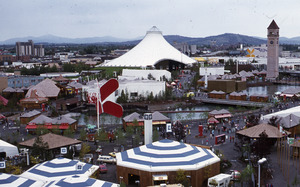
In the 1960s, Spokane business leaders wanted to improve downtown. They decided to host the first World's Fair focused on the environment. This event, Expo '74, opened on May 4, 1974. Spokane was the smallest city to host a World's Fair at that time. Expo '74 changed downtown Spokane a lot. Old railroad tracks were removed, and the area became Riverfront Park.
The economy grew in the late 1970s and early 1980s. But a recession in 1981 caused prices for silver, timber, and farm products to drop. This led to a decline that lasted into the 1990s. Many factory jobs were lost. However, Spokane's economy started to become more diverse. Companies like Key Tronic (technology) helped reduce the city's reliance on natural resources.
Spokane in the 21st Century

Today, Spokane is shifting to a more service-based economy. This means more jobs in areas like healthcare. The city is growing its medical and health sciences fields. The University District is expanding with new medical school branches.
New projects have helped downtown Spokane. The River Park Square opened in 1999. The Spokane Arena and Spokane Convention Center were expanded. Historic buildings like the Davenport Hotel and the Fox Theater have been renovated. The Kendall Yards development is a big project. It is creating new homes, shops, and walking trails near downtown.
Spokane's Geography
Land and Water Features

Spokane is in eastern Washington. It is about 1,843 feet (562 meters) above sea level. The city is about 18 miles (29 km) from Idaho. It is also 229 miles (369 km) east of Seattle. Spokane covers about 60 square miles (155 square kilometers). Most of this is land, with a small amount of water.

Spokane is located in an area called the Spokane Valley Outwash Plains. It is near the Selkirk Mountains. The foothills of the Rockies are about 25 miles (40 km) to the east. The city is a mix of dry landscapes and green forests. To the south are the rolling hills of the Palouse.
The Spokane River is the most important water feature. It flows west through downtown Spokane. It starts at Lake Coeur d'Alene in Idaho. Many large lakes in the area were formed by ancient floods. These were called the Missoula Floods. The closest national park is Mount Rainier National Park, about a four-and-a-half hour drive away.
City Layout and Buildings
Spokane's Neighborhoods

Spokane has many different neighborhoods. Some, like South Hill and Browne's Addition, have old Victorian-style homes. Others, like those in north Spokane, are more modern. Spokane has 18 National Register Historical Districts. This means many neighborhoods are recognized for their history.
Some well-known neighborhoods include Riverside, Browne's Addition, and Hillyard. Riverside is mostly downtown Spokane. It is the main business area. South of downtown are the neighborhoods known as the South Hill. Downtown has many public buildings, like City Hall and Riverfront Park.
Browne's Addition is west of downtown. It was once a very fancy area. It has many old mansions built by Spokane's wealthy early residents. These homes are in styles like Queen Anne. The Northwest Museum of Arts and Culture is in this area.
Hillyard is in northeast Spokane. It started in 1892 as a railroad yard. Many houses there were built for railroad workers. Hillyard is now home to many Russian, Ukrainian, and Southeast Asian families.
Spokane's Architecture
Commercial and Public Buildings

Spokane's buildings show its history through their different styles. Many important buildings are downtown. After the Great Fire of 1889, many were rebuilt in the Romanesque Revival style. Examples include the Great Northern clock tower and the Cathedral of Our Lady of Lourdes.
Kirtland Kelsey Cutter designed many of these buildings. He was a self-taught architect. His designs include the Spokane Club, the Monroe Street Bridge, and the Davenport Hotel. The Davenport Hotel opened in 1914. It was very modern for its time, with features like air cooling.
More recently, Warren C. Heylman designed many buildings in the mid-20th century. He used a modernist style. Some of his works include The Parkade and the Spokane International Airport.
.jpg)
Other styles seen downtown include Art Deco (like the Fox Theater) and Neoclassical (like the Bing Crosby Theater). The tallest building in Spokane is the Bank of America Financial Center.
Residential Homes
_(2877645119).jpg)
Browne's Addition has the most varied residential architecture. Its homes are grand and unique. They show popular styles from the late 1800s to 1930, like Victorian and Queen Anne. Kirtland Cutter also designed many mansions for wealthy mining and railroad owners here.
Older neighborhoods like West Central and Hillyard have many American Craftsman style bungalows. In Hillyard, most of these buildings are historic. As the city grew north, "minimal traditional" bungalows became common. These homes often have back alleys for carports and deliveries. Newer homes are found on the edges of Spokane and in the Kendall Yards neighborhood.
Parks and Recreation
.jpg)
In 1907, Spokane hired the Olmsted Brothers to plan its parks. Spokane bought much of its park land before World War I. This made it a leader in city park systems. Spokane has over 87 parks, covering 4,100 acres (17 km²). It also has six swimming centers.
Some of the most famous parks are Riverfront Park and Manito Park. Riverfront Park was created after Expo '74. It is 100 acres (40 ha) in downtown Spokane. It offers great views of the Spokane Falls. The park has a skyride that takes visitors over the falls. It also has a historic hand-carved Looff carousel from 1909. Riverfront Park is currently being updated.
Manito Park on Spokane's South Hill has the beautiful Duncan Gardens. This garden is in a classical European Renaissance style. It also has the Nishinomiya Japanese Garden. Riverside State Park, near downtown, is great for hiking and mountain biking.
The Spokane area has many trails. The Spokane River Centennial Trail is very popular. It has over 37.5 miles (60.4 km) of paved trails along the Spokane River. It goes from Spokane to the Idaho border. This trail is used for walking, biking, and other fun activities. In summer, people enjoy visiting North Idaho's lakes. In winter, there are five ski resorts within a couple of hours. Mt. Spokane Ski and Snowboard Park is the closest.
Spokane also has animal parks. Cat Tales Zoological Park is a wildlife sanctuary for big cats. The Blue Zoo is an interactive aquarium in the NorthTown Mall.
Flora and Fauna: Spokane's Wildlife
.jpg)
Spokane has a lot of wildlife because of its varied land and history. The area has many types of plants. These range from thick coniferous forests to rolling grassy hills. Ponderosa pine and Douglas fir trees are common. The ponderosa pine is Spokane's official tree.
The region is home to 70 types of mammals, 16 reptiles and amphibians, 168 birds, and 41 fish species. Many raptors live here. Bald eagles are often seen near Lake Coeur d'Alene in winter. The most common fish is the rainbow trout, which is Washington's official fish.
Large animals like black bears, Rocky Mountain elk, and moose are found in eastern Washington. Whitetail deer and mule deer are also common. The gray wolf population is growing in the Inland Northwest.
Even though the environment is mostly healthy, it faces challenges. These include the effects of logging and more forest fires. Urban growth also breaks up natural habitats. This can harm species like mountain caribou.
Spokane's Climate
.jpg)
Spokane has a warm-summer humid continental climate. This means it has warm summers and cold winters. Summers are usually warm and dry. Spring and fall are short. July is the warmest month, and December is the coolest.
Temperatures can change a lot in summer. It can be over 90°F (32°C) about 21 days a year. Temperatures over 100°F (38°C) are rare. In winter, temperatures below 0°F (-18°C) happen about 2 days a year.
_-_Spokane_Area,_WA(ThreadEx).svg)
Spokane is protected by mountains. The Cascade Mountains to the west block moist air from the Pacific Ocean. This means Spokane gets less rain than Seattle. Spokane gets about 16.5 inches (419 mm) of rain each year. Seattle gets about 39.3 inches (1,000 mm). December is the wettest month, and summer is the driest. The Rocky Mountains to the east block some of the coldest winter air from Canada.
In summer, Spokane can experience drier conditions. This leads to more frequent and larger wildfires. Smoke from these fires can affect Spokane's air quality.
Spokane's People
| Historical population | |||
|---|---|---|---|
| Census | Pop. | %± | |
| 1880 | 350 | — | |
| 1890 | 19,922 | 5,592.0% | |
| 1900 | 36,848 | 85.0% | |
| 1910 | 104,402 | 183.3% | |
| 1920 | 104,437 | 0.0% | |
| 1930 | 115,514 | 10.6% | |
| 1940 | 122,001 | 5.6% | |
| 1950 | 161,721 | 32.6% | |
| 1960 | 181,608 | 12.3% | |
| 1970 | 170,516 | −6.1% | |
| 1980 | 171,300 | 0.5% | |
| 1990 | 177,165 | 3.4% | |
| 2000 | 195,629 | 10.4% | |
| 2010 | 208,916 | 6.8% | |
| 2020 | 228,989 | 9.6% | |
| 2023 (est.) | 229,447 | 9.8% | |
| U.S. Decennial Census 2020 Census |
|||
Who Lives in Spokane?
As of 2022[update] American Community Survey estimates, Spokane had about 230,176 people and 101,130 households. The city's population density was about 3,347.5 people per square mile (1,292.5 per km²).
Most people in Spokane are White (80.7%). Other groups include Black or African American (2.5%), Asian (2.0%), and Native American (0.8%). About 10.5% of people are from two or more races. Hispanics or Latinos make up 8.1% of the population.
About 24.5% of households have children under 18. About 29.8% have seniors (65 or older). The average household size is 2.21 people. The average family size is 2.96 people.
The median age in Spokane is 38.6 years. About 18.8% of people are under 18. About 17.6% are 65 or older.
The median income for a household was $62,287. For families, it was $90,205. The average income per person was $38,173. About 11.8% of people live below the poverty line.
Many people in Spokane have German (19.5%), English (13.1%), or Irish (11.5%) backgrounds. There are also growing Russian, Ukrainian, and Southeast Asian communities.

Religion in Spokane
Spokane has many different religious groups. The largest groups are Evangelical Protestant, Catholic, and Mainline Protestant. There are also Jewish congregations and a mosque. Spokane is part of a region known for lower church membership rates.
The city is home to the main churches for the Roman Catholic Diocese of Spokane and the Episcopal Diocese of Spokane. The Spokane Washington Temple serves Latter-day Saints.
Spokane has a yearly event called Unity in the Community. It celebrates different cultures. The city has become more diverse. Many people from the former Soviet Union (like Russians and Ukrainians) moved here after 1991. The Pacific Islander community is also growing fast.
Spokane once had a large Asian community called Chinatown. It was a home for migrant workers. This community thrived until the 1940s. It later became smaller and was removed for new city projects.
.png)
Spokane's Metropolitan Area
The Spokane metropolitan area includes Spokane County. In 2022, it had about 597,919 people. East of Spokane County is the Coeur d'Alene area in Idaho. The cities of Spokane and Coeur d'Alene are connected by Interstate 90.
Spokane has seen some urban sprawl, where cities spread out. However, a 2014 study ranked Spokane as one of the most compact and connected cities. The Spokane and Coeur d'Alene areas are now considered one larger region. This region had about 781,497 residents in 2022.
Spokane's Economy

Spokane became an important shipping center because of its location. It was between mining and farming areas. In the early 1880s, gold and silver were found nearby. Spokane supplied miners heading to these rich areas. These mining areas are still very productive.
Historically, Spokane's economy was based on natural resources. Mining, logging, and agriculture were key industries. After mining slowed down, farming and logging became most important. Spokane supplied lumberjacks and mill workers.
Agriculture has always been vital. The Palouse region, south of Spokane, is one of the largest wheat-producing regions in the United States. Spokane was a major market for farm products. Farmers exported wheat and livestock to places like New York and Tokyo. Today, much of the wheat goes to Asia. The region also has many vineyards and breweries.

Today, Spokane's manufacturing includes wood and food processing. It also has printing, metal refining, and electrical equipment. Gold Reserve (a gold mining company) and Potlatch Corporation (a forest products company) have their main offices here.
Spokane's economy has become more diverse. It now includes high-tech and biotech industries. It is becoming a center for medical and biotechnology. Itron, a technology company, is based here. Avista Utilities is a local utility company. Other companies with offices in Spokane include Key Tronic and Commuter Cars.
Spokane's economy has faced challenges. In some years, it was ranked as a "Worst City For Jobs." It was also called the "Scam Capital of America" in 2009 due to business fraud.
As of 2013, the top employers are the State of Washington, Spokane Public Schools, and Providence Sacred Heart Medical Center and Children's Hospital. Fairchild Air Force Base is also a major employer. Spokane is a hub for business, manufacturing, and healthcare in the Inland Northwest. In 2017, the Spokane area's economy was worth $25.5 billion.
Spokane is growing as a technology hub. Companies like F5, Inc. have offices here. Remitly, a financial services company, was founded by a Whitworth University graduate. Ignite Northwest helps fund new companies.
Spokane's Culture

Arts and Theater in Spokane
Spokane has several art districts. These include the Davenport Arts District and the Garland Business District. On the first Friday of every month, the First Friday Artwalk takes place. Local artists and performers show their work downtown.
The Davenport Arts District has many art galleries. It is also home to major performance venues. These include the Knitting Factory, Fox Theater, and Bing Crosby Theater. The Knitting Factory hosts many touring musicians. The Martin Woldson Theater at the Fox is home to the Spokane Symphony Orchestra. The Bing Crosby Theater is named after the famous singer who grew up in Spokane.
The Spokane Civic Theatre and other local groups offer plays. The First Interstate Center for the Arts hosts large traveling shows. Spokane has won the All-America City Award three times.
Spokane has various musical performances. The Spokane Symphony plays classical music. The Spokane Jazz Orchestra performs jazz.
Spokane's Museums
.jpg)
Spokane has several museums. The most notable is the Northwest Museum of Arts and Culture. It is near downtown in Browne's Addition. This museum is connected to the Smithsonian. It has a large collection of Native American items. It also hosts traveling art exhibits.
The Mobius Science Center and Mobius Kid's Museum are downtown. They help kids learn about science, technology, engineering, and math. The Jundt Art Museum at Gonzaga University has many art collections. It includes glass art by Dale Chihuly.
At Gonzaga University, the Crosby House was Bing Crosby's childhood home. It now has the world's largest collection of his items. A flight museum at Felts Field shows historic airplanes.
Events and Activities in Spokane
Spokane is known as the birthplace of Father's Day. Sonora Smart Dodd started the idea here in 1910. She thought of it while listening to a Mother's Day sermon.

The Lilac Bloomsday Run is a 7.46-mile (12.01 km) race. It happens in spring on the first Sunday of May. It attracts runners and walkers from all over. Also in May is the Lilac Festival. Spokane is called the "Lilac City" because these flowers grow well here.
In June, Spokane hosts Spokane Hoopfest. This is a huge 3-on-3 basketball tournament. One of the most popular local events is Pig Out in the Park. This is a six-day food and entertainment festival. People can try different foods and listen to free live music in Riverfront Park (Spokane, Washington).
The Spokane International Film Festival happens every February. It shows documentaries and short films from around the world.
Other events include the Spokane County Interstate Fair in September. Japan Week in April celebrates Spokane's sister-city relationship with Nishinomiya, Hyogo, Japan. The Spokane Pride Parade is held each June. There is also an annual Renaissance fair and Civil War reenactment.
Education in Spokane

Spokane has two public library systems. The Spokane Public Library serves the city. The Spokane County Library District serves the county. The Spokane Public Library started in 1904. It has a main library and five branches. It has special collections on the history of the Inland Pacific Northwest.
Schools for Kids
Spokane Public Schools (District 81) is the largest public school system in Spokane. It is the second-largest in Washington state. It serves about 30,000 students. It has six high schools, six middle schools, and thirty-four elementary schools. Other public school districts are in the Spokane area, like the Mead School District. There are also many private and religious schools. The Roman Catholic Diocese of Spokane manages ten of these schools.
Colleges and Universities

Spokane has many colleges and universities. These include private universities like Gonzaga and Whitworth. There are also public colleges like Spokane Community College and Spokane Falls Community College.
Gonzaga University was founded by Jesuits in 1887. Whitworth University started in 1890. It is connected to the Presbyterian Church.
While Spokane does not have a main state university campus, Eastern Washington University (EWU) and Washington State University (WSU) have branches here. Their campus is called the Riverpoint Campus. It is next to downtown. Washington State University Spokane is WSU's health sciences campus. It has colleges for nursing, pharmacy, and medicine. The University of Washington also has a medical school branch here.
Sports in Spokane

Spokane is close to many lakes and rivers. These are great for outdoor sports like swimming, boating, and fishing. Nearby mountains offer skiing, hiking, and biking.
Spokane has professional and semi-professional sports teams. These include the Spokane Indians (baseball) and the Spokane Chiefs (ice hockey). College sports are popular too. The Gonzaga Bulldogs basketball team plays in Division I. The Whitworth Pirates play in Division III.
Baseball in Spokane
The Spokane Indians are a baseball team. They play in Spokane Valley. They are a farm team for the Colorado Rockies. The Indians play at Avista Stadium. They have won seven league titles. Before 1982, the Indians played at a higher level of baseball.
Hockey in Spokane
The Spokane Chiefs are a junior ice hockey team. They play in the Western Hockey League. Their home games are at the Spokane Arena. They have a rivalry with the Tri-City Americans. The Chiefs have won the Memorial Cup (a top Canadian hockey prize) twice.
Soccer in Spokane
Spokane has professional men's and women's soccer teams. The men's team is Spokane Velocity FC. The women's teams are a pre-professional USL W League team and a professional USL Super League team (Spokane Zephyr FC). They play their home games at ONE Spokane Stadium.
Major Sports Events
The Spokane Arena is the city's main sports venue. It has hosted many big sporting events. These include the 1998 Memorial Cup (hockey) and 2002 Skate America (figure skating). In 2007, Spokane hosted the 2007 U.S. Figure Skating Championships. This event set an attendance record. Spokane also has The Podium, an indoor track and event space.
Media in Spokane

Newspapers and Print
Spokane's main daily newspaper is The Spokesman-Review. It was formed in 1893. It later took over another newspaper, The Spokane Daily Chronicle. Other publications include the weekly Inlander and the bi-weekly Spokane Journal of Business. There are also student newspapers, community newspapers, and magazines.
Radio Stations
Spokane is a large radio market. There are 28 AM and FM radio stations. Some of the most popular stations play classic rock, news/talk, country, and pop music. Spokane also has NPR and community radio stations.
Television Channels
Spokane is a major television market. It has six TV stations. These include channels for CBS, ABC, NBC, FOX, The CW, and PBS. Spokane is the TV broadcast center for much of eastern Washington and northern Idaho.
Spokane's Infrastructure

Getting Around Spokane: Transportation
City Streets
Spokane's streets are set up in a grid plan. East-west roads are usually avenues, and north-south roads are streets. Major roads include Francis, Wellesley, and Sprague Avenues. Important north-south roads are Maple–Ash, Monroe, and Division Streets. Division Street divides the city into East and West. Sprague Avenue divides it into North and South. North Division Street is Spokane's busiest road.
Spokane has a large skywalk system downtown. It covers thirteen blocks. People use it to walk between buildings, especially in bad weather. Spokane has an average Walk Score of 49, meaning most errands need a car. Its Bike Score is 52.

Public Transportation
Before cars became popular, Spokane had electric streetcars. These helped people and goods move around. Many old side streets still have streetcar rails. Streetcar service ended in 1936.
Spokane has train and bus service. Amtrak's Empire Builder train stops here. Greyhound and other bus companies also serve the city. Spokane is a major railway junction for freight trains.
The Spokane Transit Authority (STA) provides public bus service. It has 164 buses. The STA Plaza downtown is the main hub for most bus routes. In 2023, STA launched the City Line. This is Eastern Washington's first bus rapid transit (BRT) route.
Highways and Freeways

Interstate 90 (I-90) runs through downtown Spokane. It connects to Seattle and goes eastward into Idaho. US 2 and US 395 also go through Spokane. They share the same route for a while. US 195 connects to I-90 west of Spokane.
The Washington State Department of Transportation (WSDOT) is building the North Spokane Corridor. This will be a 10.5-mile (16.9 km) highway. It will run from I-90 northward through Spokane.
Airports

Spokane International Airport (GEG) is the main airport for Spokane. It is the second-largest airport in Washington state. It is 5 miles (8 km) west of downtown Spokane. The airport's code "GEG" comes from its old name, Geiger Field.
Felts Field is a smaller airport in east Spokane. It is used for general aviation. It was Spokane's main airport until after World War II.
Healthcare in Spokane

Spokane has six major hospitals. The healthcare industry is very important here. The city provides special medical care for many patients from the surrounding region. The main hospitals are Sacred Heart Medical Center and Deaconess Hospital.
Most of Spokane's major healthcare facilities are in the "Medical District." This area is just south of downtown. Sacred Heart Hospital opened in 1887. It is a large hospital with many beds. Deaconess Medical Center is also a large hospital. Other hospitals include the Spokane Veterans Affairs Medical Center and Providence Holy Family Hospital. One of 20 specialty orthopedic Shriners Hospitals is in Spokane.
City Services: Utilities

The City of Spokane provides water, wastewater management, and trash services. Spokane has Washington's only waste-to-energy plant. This plant burns trash to create electricity. The extra electricity is sold to Puget Sound Energy.
Spokane gets its water from the Spokane Valley–Rathdrum Prairie Aquifer. This underground water source is very large and pure. It provides water for over 500,000 people.
Avista Utilities provides natural gas and electricity. CenturyLink and Comcast offer TV, internet, and phone services. Spokane has three hydroelectric dams on the Spokane River. These dams generate electricity for the city.
Notable People from Spokane
Sister Cities
Spokane has sister city relationships with cities around the world. These relationships help promote cultural exchange and understanding.
 Nishinomiya, Japan – since September 1961 (Spokane's first sister city)
 Jecheon, South Korea
 Jilin City, China
 Limerick, Republic of Ireland
 San Luis Potosí City, Mexico
 Cagli, Italy
See also
 In Spanish: Spokane (Washington) para niños
