Spokane County, Washington facts for kids
Quick facts for kids
Spokane County
|
||
|---|---|---|

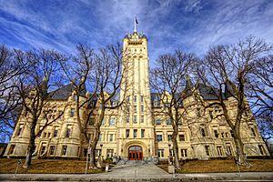
Spokane County Courthouse
|
||
|
||

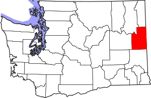
Location within the U.S. state of Washington
|
||
 Washington's location within the U.S. |
||
| Country | ||
| State | ||
| Founded | January 29, 1858 (created) January 19, 1864 (annexed to Stevens Co.) October 30, 1879 (separated from Stevens Co.) |
|
| Named for | Spokane people | |
| Seat | Spokane | |
| Largest city | Spokane | |
| Area | ||
| • Total | 1,781 sq mi (4,610 km2) | |
| • Land | 1,764 sq mi (4,570 km2) | |
| • Water | 17 sq mi (40 km2) 0.9%% | |
| Population
(2020)
|
||
| • Total | 539,339 | |
| • Estimate
(2023)
|
551,455 |
|
| • Density | 275/sq mi (106/km2) | |
| Demonym(s) | Spokanite | |
| Time zone | UTC−8 (Pacific) | |
| • Summer (DST) | UTC−7 (PDT) | |
| Congressional district | 5th | |
Spokane County is a county located in the U.S. state of Washington. It is the fourth-most populated county in Washington. As of 2020, about 539,339 people lived there. The biggest city and the county's main office is Spokane. This city is the second largest in Washington, after Seattle. The county gets its name from the Spokane people, a Native American tribe.
Spokane County is part of the Spokane metropolitan area. This larger area also includes nearby Kootenai County, Idaho.
Contents
History of Spokane County
The first people came to what is now Spokane County a very long time ago, between 12,000 and 8,000 years ago. They were hunter-gatherers, meaning they found their food by hunting animals and gathering plants. At first, they hunted large animals like bison and antelope. Later, when these animals moved away, the people started to rely more on gathering roots, berries, and nuts, and catching fish.
The Spokane tribe gave the county its name. In their language, "Spokane" means "Children of the Sun" or "sun people."
Early European Explorers
David Thompson was the first European to explore this area. He worked for a fur trading company. In 1810, he sent two trappers to build a fur-trading post on the Spokane River. This post was called Spokane House. It was the first lasting European settlement in Washington state. Spokane House was open from 1810 to 1826.
How Spokane County Was Formed
Spokane County was officially created on January 29, 1858. It was formed from a part of Walla Walla County. At first, Spokane County was very large. It included parts of modern-day Idaho and Montana. The first county government met on May 8, 1860.
Over time, parts of Spokane County were used to create new counties. This happened as more people moved into the area. In 1864, Spokane County was joined with Stevens County. But it was made a separate county again on October 30, 1879.
Choosing the County Seat
The county seat is where the main government offices are located. For Spokane County, there was a big argument about where it should be. The cities of Cheney and Spokane Falls (now Spokane) both wanted to be the county seat.
In 1880, an election was held. The results were very close and caused a lot of disagreement. People from Cheney even took county records by force to prove their city had won! Finally, in 1886, another vote was held. This time, Spokane became the permanent county seat.
Geography of Spokane County
Spokane County covers about 1,781 square miles. A small part of this area, about 17 square miles, is water. The lowest point in the county is along the Spokane River, at about 1,538 feet above sea level. The highest point is the top of Mount Spokane, which is about 5,887 feet high.
The county's landscape is very interesting. To the west, you'll find flat, dry plains. To the east, there are hills and forests that lead up to the Rocky Mountains. This area shows signs of huge floods that happened long ago, called the Missoula Floods. These floods shaped the land thousands of years ago.
Rivers and Streams
- Spokane River
- Cable Creek
- Latah Creek
- Marshall Creek
- Garden Springs Creek
- Little Spokane River
- Deep Creek
- Coulee Creek
- Saltese Creek
Lakes and Reservoirs
- Eloika Lake
- Liberty Lake
- Medical Lake
- West Medical Lake
- Newman Lake
- Shelley Lake
Notable Summits and Peaks
Notable Parks
- Dishman Hills Natural Conservation Area
- Riverside State Park
- Riverfront Park
- Manito Park
- Mount Spokane State Park
National Protected Area
Major Highways
 Interstate 90
 U.S. Route 2
 U.S. Route 195
 U.S. Route 395
 State Route 27
 State Route 206
 State Route 290
 State Route 291
 State Route 902
 State Route 904
Neighboring Counties
- Stevens County – northwest
- Pend Oreille County – north
- Bonner County, Idaho – northeast
- Kootenai County, Idaho – east
- Benewah County, Idaho – southeast
- Whitman County – south
- Lincoln County – west
People of Spokane County
| Historical population | |||
|---|---|---|---|
| Census | Pop. | %± | |
| 1860 | 996 | — | |
| 1870 | 2,000 | 100.8% | |
| 1880 | 4,262 | 113.1% | |
| 1890 | 37,487 | 779.6% | |
| 1900 | 57,542 | 53.5% | |
| 1910 | 139,404 | 142.3% | |
| 1920 | 141,289 | 1.4% | |
| 1930 | 150,477 | 6.5% | |
| 1940 | 164,652 | 9.4% | |
| 1950 | 221,561 | 34.6% | |
| 1960 | 278,333 | 25.6% | |
| 1970 | 287,487 | 3.3% | |
| 1980 | 341,835 | 18.9% | |
| 1990 | 361,364 | 5.7% | |
| 2000 | 417,939 | 15.7% | |
| 2010 | 471,221 | 12.7% | |
| 2020 | 539,339 | 14.5% | |
| 2023 (est.) | 551,455 | 17.0% | |
| U.S. Decennial Census 1790–1960 1900–1990 1990–2000 2010–2020 |
|||
2020 Census Information
| Race | Number | Percent |
|---|---|---|
| White (NH) | 431,806 | 80.1% |
| Black or African American (NH) | 10,486 | 1.9% |
| Native American (NH) | 6,862 | 1.3% |
| Asian (NH) | 12,404 | 2.3% |
| Pacific Islander (NH) | 4,202 | 0.8% |
| Some Other (NH) | 2,644 | 0.5% |
| Other/Mixed (NH) | 35,585 | 6.6% |
| Hispanic or Latino | 35,350 | 6.6% |
In 2020, there were 539,339 people living in Spokane County. About 80% of the people were White. Other groups included African American, Native American, Asian, and Pacific Islander. About 6.6% of the population was Hispanic or Latino.
About 21% of the people were under 18 years old. Also, 17.5% were 65 years or older. Most adults, about 94%, had a high school diploma or higher. About 31.5% had a college degree.
The average income for a household in 2021 was about $64,079. About 11.2% of the county's population lived in poverty.
Communities in Spokane County
Cities
- Airway Heights
- Cheney
- Deer Park
- Liberty Lake
- Medical Lake
- Millwood
- Spangle
- Spokane (county seat)
- Spokane Valley
Towns
Census-Designated Places (CDPs)
These are areas that are like towns but are not officially incorporated as cities.
- Country Homes
- Fairchild Air Force Base
- Fairwood
- Four Lakes
- Mead
- Otis Orchards-East Farms
- Town and Country
Unincorporated Communities
These are smaller communities that are not part of any city or town.
- Amber
- Buckeye
- Chattaroy
- Colbert
- Deep Creek
- Denison
- Duncan
- Dynamite
- Elk
- Espanola
- Freeman
- Garden Springs
- Geiger Heights
- Glenrose
- Greenacres
- Green Bluff
- Hazard
- Highland
- Manito
- Marshall
- Mica
- Milan
- Moab
- Mount Hope
- Newman Lake
- Nine Mile Falls
- Orchard Prairie
- Peone
- Plaza
- Riverside
- Seven Mile
- Silver Lake
- Spokane Bridge
- Spring Valley
- Stringtown
- Tyler
- Valleyford
- Veradale
Ghost Towns/Neighborhoods
These are places that used to be communities but are now mostly abandoned.
- Babb
- Coey
- Darknell
- Dragoon
- Freedom
- Geib
- Hite
- Lyons
- Mock
- North Pine
- Rahm
- Rodna
- Saxby
- Scribner
- Wallner
Education in Spokane County
Spokane County has many schools and colleges.
School Districts
- Central Valley School District
- Cheney School District
- Deer Park School District
- East Valley School District (Spokane)
- Freeman School District
- Great Northern School District
- Liberty School District
- Mead School District
- Medical Lake School District
- Newport School District
- Nine Mile Falls School District
- Orchard Prairie School District
- Reardan-Edwall School District
- Riverside School District
- Rosalia School District
- Spokane Public Schools
- St. John School District
- Tekoa School District
- West Valley School District (Spokane)
Community Colleges
- Spokane Community College
- Spokane Falls Community College
Universities
- Eastern Washington University
- Gonzaga University
- Washington State University
- Whitworth University
- University of Washington
See also
 In Spanish: Condado de Spokane para niños
 | William M. Jackson |
 | Juan E. Gilbert |
 | Neil deGrasse Tyson |


