
Mica, Washington facts for kids
Quick facts for kids
Mica, Washington
|
|
|---|---|
 |
|

Mica, Washington
Location in Washington (state)
|
|
| Country | United States |
| State | Washington |
| County | Spokane |
| Elevation | 2,480 ft (760 m) |
| Population | |
| • Total | 563 |
| Time zone | UTC-8 (Pacific (PST)) |
| • Summer (DST) | UTC-7 (PDT) |
| ZIP code |
99023
|
| Area code(s) | 509 |
| GNIS feature ID | 1512460 |
Mica is a small community in Spokane County, Washington, United States. It's called an "unincorporated community" because it doesn't have its own local government like a city or town. Instead, it's managed by the county. Mica is located about 12 miles (19 km) southeast of downtown Spokane. It used to have its own post office with a ZIP code of 99023.
Contents
History of Mica
Mica got its name from the mineral called mica, which was found in the area. A post office was first opened here in 1887. It helped people send and receive mail until it closed in 1975.
Brick Making in Mica
For a long time, making bricks has been very important to Mica's economy. The first brick factory, American Fire Brick, was started by early settlers in the late 1800s. Today, the factory is owned by Mutual Materials. It still makes bricks on the same land. The old American Firebrick Company buildings were added to the National Register of Historic Places in 1982. This means they are important historical sites.
Mica's Growth and Changes
The oldest grave in the Mica Cemetery dates back to 1883. This shows how long people have lived in the area. Mica is only about a ten-minute drive from Spokane Valley. Because of this, more people have moved to Mica. It has become a "bedroom community." This means many people who live in Mica travel to work in bigger nearby cities. This has made Mica less completely rural than it used to be.
Geography of Mica
Mica is located along Washington State Route 27. This road connects Mica to Spokane Valley to the north. It also links Mica to other small towns in the Palouse region to the south.
Surrounding Landscape
Mica is on the northern edge of the Palouse. This area is known for its gently rolling hills. Just north and east of Mica, these hills quickly turn into the foothills of the Selkirk Mountains. You can see Krell Hill (also called Tower Mountain) to the northwest. It has television towers on it. Mica Peak is located just to the east. California Creek flows from Mica Peak and runs along the southeastern edge of the town. This creek is a branch of Latah Creek.
Schools and Environment
Mica is part of the Freeman School District. The elementary, middle, and high schools are about three miles south of town on State Route 27.
Mica is in a special spot where three different ecoregions meet. An ecoregion is a large area with similar plants, animals, and climate.
- The Okanagan dry forests ecoregion starts near Mica. It has tall ponderosa pine trees.
- The North Central Rockies forests ecoregion is found as the land goes up into the Selkirk Mountains.
- A few miles south of Mica, you'll find the rolling, grassy hills of the Palouse grasslands ecoregion. This mix of ecoregions gives Mica a unique natural environment.
Gallery
-
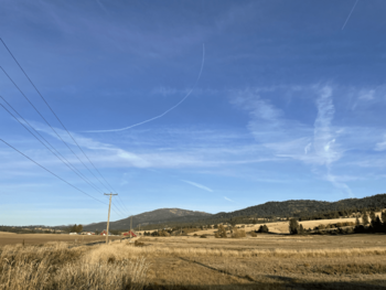
Mica Peak as seen from the eastern edge of Mica from Belmont Road.
-
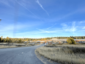
Brickyard in Mica, where bricks have been made since 1902, as seen from Washington State Route 27.


Images for kids
-
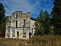
An abandoned building at the American Firebrick Company brickyard in Mica.

See also
 In Spanish: Mica (Washington) para niños
