
Latah Creek facts for kids
Quick facts for kids Latah Creek |
|
|---|---|

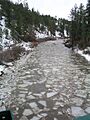
Ice-jam break up on Latah Creek, 2005
|
|


Location of the mouth of Latah Creek in Idaho
|
|
| Native name | Snt'ut'u'lmkhwkwe |
| Other name(s) | Hangman Creek |
| Country | United States |
| State | Washington (state), Idaho |
| Cities | DeSmet, ID, Tekoa, WA, Latah, WA, Spokane, WA |
| Physical characteristics | |
| Main source | Charles Butte Benewah County, Idaho 1,716 ft (523 m) 47°06′53″N 116°43′0″W / 47.11472°N 116.71667°W |
| River mouth | Spokane River Spokane, Spokane County, Washington 523 ft (159 m) 47°39′36″N 117°27′28″W / 47.66000°N 117.45778°W |
| Length | 60 mi (97 km) |
| Basin features | |
| Basin size | 673 sq mi (1,740 km2) |
| Tributaries |
|
Latah Creek ( LAY-tə), also known as Hangman Creek, is a large stream in the United States. It flows through eastern Washington and north central Idaho. The creek starts in the Rocky Mountains and flows northwest. It eventually joins the Spokane River in Spokane.
Latah Creek's watershed covers about 673 square miles (1,740 km2). Most of this area is in Spokane County, Washington. The creek is about 60-mile (97 km) long. Important smaller streams that flow into it include Little Latah Creek and Rock Creek. The amount of water flowing in the creek changes a lot. It can range from 20 cubic feet per second (0.57 m3/s) to 20,000 cubic feet per second (570 m3/s).
The name "Latah" comes from a Nez Perce word that probably means "fish". The name "Hangman Creek" was given in 1854. This happened after a conflict between the Palouse Indians and white soldiers.
Most of the land around Latah Creek is used for agriculture. This farming has caused a lot of soil to wash into the creek. This extra soil has harmed the natural fish, plants along the banks, and the way the water flows. Some parts of the creek have been straightened, which has destroyed its natural curves and islands. Because of these issues, the water quality in Latah Creek is often low. Washington State's water quality rules for temperature, oxygen, pH, and bacteria are often not met.
Contents
Why Does Latah Creek Have Two Names?
The name "Latah" comes from a Nez Perce word. It might mean "a place of pines and sestles" or "fish". People believe this name has been used for a very long time.
The name "Hangman" came from a historical event. In 1854, after a conflict, some Palouse Indians were executed along the creek. This led to the name "Hangman Creek."
Today, the state of Washington and Spokane County officially call it Latah Creek. However, the federal government still uses "Hangman." There have been discussions about whether "Hangman" is too harsh a name.
Other names used for the creek over time include Sin-sin-too-ooley, Camas Prairie Creek, and Ned-Wauld River. When the Lewis and Clark Expedition explored the area in 1805, they thought the name was "Lau-taw."
Where Does Latah Creek Flow?

Latah Creek starts in Benewah County, Idaho. Its headwaters are in a small valley south of Charles Butte. A few miles after it begins, the South Fork Latah Creek joins it. The creek then flows north past the towns of Sanders and De Smet. Here, it enters channeled scablands that are now farmland.
The creek then crosses into Washington State. It flows through Tekoa, where it is straightened. At Tekoa, a large stream called Little Latah Creek joins it.
After Tekoa, Latah Creek continues north along State Route 27. It passes the town of Latah, which is named after the creek. The creek then flows west and north, passing near Waverly and West Fairfield. Another large stream, Rock Creek, then joins Latah Creek.
Further on, California Creek, which is about 8-mile (13 km) long, also flows into Latah Creek. In its last few miles, Latah Creek flows through a widening canyon. It runs next to U.S. Highway 195 as it approaches Spokane. The creek then receives Marshall Creek and Spring Creek. It flows under several bridges, including those for U.S. Highway 395. Its last stream, Indian Canyon Creek, joins it before Latah Creek turns northeast. Finally, Latah Creek joins the Spokane River near Spokane Falls.
Little Latah Creek's Journey
Little Latah Creek is about 10 miles (16 km) long. It generally flows southwest. This creek starts a few miles south of Plummer. U.S. Highway 95 crosses it near its beginning.
For its whole length, Little Latah Creek follows Lovell Valley Road. Its largest stream, Moctileme Creek, joins it near the border of Idaho and Washington. Moctileme Creek is about 6 miles (9.7 km) long. Little Latah Creek gets bigger from water runoff from farms. It then flows through Tekoa and under Washington State Route 27 before joining Latah Creek.
Rock Creek's Path
Rock Creek is also about 10 miles (16 km) long. It starts about 1-mile (1.6 km) west-southwest of Worley. The creek flows west from its start. Its North Fork, which is longer, joins it.
Rock Creek then crosses into Washington State. It flows west of Rockford. It then turns west and north, going under State Route 27. The creek enters a narrow canyon, similar to Latah Creek's. After winding through the canyon, it straightens and flows west-northwest. Rock Creek then turns sharply south and flows into Latah Creek.
How Was Latah Creek Formed?

Latah Creek flows through three different types of land.
- Upper Headwaters: The creek starts in the foothills of the Rocky Mountains, specifically the Clearwater Mountains. Here, the land has steep ridges and peaks. The valleys are deep and forested, with rocky streams.
- Broad Valley: After the mountains, the creek flows through the older, rounded Palouse Hills. Below the deep soil here, a layer of basalt rock separates the creek from groundwater. Most of the creek flows in a wide, shallow valley with many alluvial deposits (materials left by water).
- Channeled Scablands: In its last 20 miles (32 km), Latah Creek enters the Channeled Scablands. These were formed by the huge Missoula Floods. These floods happened during the last Ice Age when an ice dam broke. The floods left behind "terraces" of material. The creek has cut through these, creating steep gravel slopes and cliffs. Near Spokane, the creek flows in a nearly straight line. This is because of a strike-slip fault (a crack in the Earth's crust) called the Latah Creek Fault.
Latah Creek's Watershed

The area that drains into Latah Creek, called its watershed, covers about 673 square miles (1,740 km2). It stretches from southeast to northwest across the Washington-Idaho border. The climate is mostly semiarid (dry). The land is mainly forests and farms, with small towns along the creek. Spokane is the largest city in the watershed.
The creek used to flow in winding paths and braided streams across a wide flat area. But turning this land into farms made the creek flow straighter. This has led to more erosion and cloudy water, and less healthy water and habitats for animals. At its mouth, Latah Creek can provide up to 90 percent of the water flow to the Spokane River.
On the east side, the land divides Latah Creek from streams that flow into Coeur d'Alene Lake. Streams that flow into Latah Creek from the right (east) include Little Latah Creek and Rock Creek. Streams from the left (west) include Marshall Creek. The watershed is bordered by the Palouse River to the south. There are no dams on the main part of Latah Creek.
Farming uses about 212,880 acres (861.5 km2) of the Latah Creek watershed. Forests cover about 119,490 acres (483.6 km2). Cities and towns cover only about 12,565 acres (50.85 km2). Because Latah Creek flows into the Spokane River, pollution in Latah Creek directly affects the Spokane River.
How Does Latah Creek's Water Flow Change?
The amount of water in Latah Creek changes a lot. The creek often floods in winter and spring. In summer, it can become very low, almost dry. However, it usually doesn't dry up completely because of water returning from farms.
The average monthly flow is 242 cubic feet per second (6.9 m3/s). In winter and spring, the average peak flow is about 7,585 cubic feet per second (214.8 m3/s).
- The highest recorded flow was 21,200 cubic feet per second (600 m3/s) on January 1, 1997.
- The lowest recorded peak flow was 395 cubic feet per second (11.2 m3/s) in 1994.
History of Latah Creek
In 1854, Latah Creek got its other name, Hangman Creek. This name lasted for over 150 years. There's a story about a Palouse Indian named Qualchan. He found a cavalry camp and, during a blizzard, led the soldiers' horses away. Later, after a brief conflict, Qualchan and six other Palouse people were captured and executed along Latah Creek. This gave the creek its name. More people were executed there later that year.
After these events, the Washington State government and the U.S. Board on Geographic Names often disagreed on the creek's name. Washington State calls it Latah, but the federal board and many local people still use Hangman.
A large bog (a type of wetland) existed next to Latah Creek for thousands of years. In 1876, a homesteader named Benjamin Coplen found a giant bone there. He found more bones, including a vertebra and a shoulder blade. These were later identified as belonging to a woolly mammoth. Other homesteaders also found mammoth bones. These bones were shown in different cities and eventually went to the Field Museum of Natural History in Chicago. Scientists believe the Missoula Floods helped create the bog where these ancient bones were found.
Fish Species in Latah Creek
In the early 1800s, Latah Creek was described as a clear stream. It was a good home for anadromous fish (fish that swim from the ocean to fresh water to lay eggs). However, the creek was naturally shallow and slow. It wasn't a very important place for these types of fish.
The main fish found in Latah Creek were sucker and whitefish. Because the area is dry and there's more pollution, Latah Creek is not as good a habitat for fish and other water animals today. Even in 1892, the creek was described as "a small filthy stream not suitable for trout but well supplied with minnows and suckers."
Between 1892 and 1974, two fish species, the Bridgelip sucker and Chiselmouth, seem to have disappeared from the creek. Many types of suckers were found in 1892, and some are still there today. The Native American name for the creek, Snt'ut'u'lmkhwkwe, means "Suckers in the Water." This suggests that suckers have always been the main fish in Latah Creek.
Images for kids
-
Ice-jam break up on Latah Creek, 2005
-
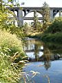
Sunset Highway and I-90 Crossing Latah Creek in Spokane.
-
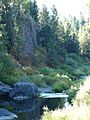
Exposed Basalt along the creek in Spokane.
-
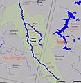
Map of the Latah Creek watershed
