Channeled Scablands facts for kids
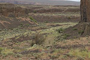
The Channeled Scablands are a unique landscape in the southeastern part of Washington in the United States. This area is mostly bare, rocky, and has many dry channels, valleys called coulees, and dry waterfalls. These features were carved into the land by huge, powerful floods.
More than 40 of these "cataclysmic" floods swept across eastern Washington during the last Ice Age, between 18,200 and 14,000 years ago. Many older floods also happened over the last two million years. These floods occurred when a giant glacial lake repeatedly broke through its ice dam and drained, sending massive amounts of water across the land.
Geologist J Harlen Bretz was the first to describe the "scablands" in the 1920s. He noted that the floods stripped away the soil, leaving behind bare basalt rock and creating a landscape with flat-topped hills (called buttes) and deep basins. He famously said, "The channels run uphill and downhill, they unite and they divide... they could not be more erratically and impossibly designed."
For about 40 years, scientists debated how the Scablands were formed. This debate became a major topic in earth science. The Scablands are also important to scientists studying other planets, as they look similar to some outflow channels found on Mars.
How the Scablands Were Discovered
In the 1920s, a geologist named J Harlen Bretz studied the Channeled Scablands. He published many papers describing how they looked. Bretz believed that these features could only have been formed by incredibly large and fast floods. He estimated these floods were about 500 cubic miles (2,080 cubic kilometers) of water! However, he couldn't explain where such a huge amount of water came from.
Most geologists at the time disagreed with Bretz. They believed in a theory called uniformitarianism, which suggests that Earth's features are formed by slow, gradual processes over long periods, not by sudden, massive events like floods.
Then, in 1925, another geologist named J.T. Pardee suggested an answer to Bretz. Pardee thought that a large glacial lake could have drained quickly, causing the massive floods. Pardee spent the next 30 years researching this idea. He gathered evidence that pointed to Lake Missoula as the source of these floods, now known as the Missoula Floods.
It took many years of hard work and strong scientific discussions before Bretz's and Pardee's ideas were finally accepted. In the 1970s, new research on how water flows in open channels supported Bretz's theories. In 1979, Bretz received the highest award from the Geological Society of America, the Penrose Medal. This award recognized his groundbreaking ideas in earth science.
What the Scablands Look Like
The Channeled Scablands have many unique landforms. These include:
- Coulees: These are long, deep, flat-bottomed valleys with steep sides.
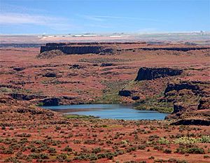
- Dry Falls: These are places where huge waterfalls once plunged, but now there's no water.
- Streamlined Hills: These hills and islands of soil were shaped by the powerful floodwaters, making them look like they were carved by a fast current.
- Gravel Bars: These are large piles of gravel and rocks deposited by the floods.
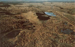
- Giant Current Ripples: These are huge ripple marks, like those you see on a streambed, but much, much bigger. They can be between 3 and 50 feet (1 to 15 meters) high! It would take an enormous amount of water to create ripples this size.
- Potholes: These are large, deep holes in the bedrock. They were formed by swirling whirlpools of water, called kolks, that drilled into the rock.
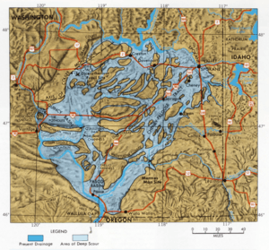
Unlike typical river valleys (which are V-shaped) or glacier-carved valleys (which are U-shaped), the Channeled Scablands often have a rectangular shape, with flat tops and steep canyon walls. This unique shape covers a vast area of eastern Washington, estimated to be between 1,500 and 2,000 square miles (3,885 and 5,180 square kilometers).
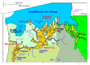
The floods that created the Scablands came from Glacial Lake Missoula. This lake was formed when the Cordilleran Ice Sheet (a huge sheet of ice) blocked a river. When the ice dam broke, a series of floods swept across the landscape. This happened many times between 18,000 and 13,000 years ago. The channels carved by these floods look like a braided pattern, similar to how many small streams might intertwine.
Scientists have found evidence of many floods, not just the ones from the last Ice Age. Some deposits show that floods happened as far back as 1.5 million years ago! While it's hard to know the exact number, it's possible that hundreds, or even more than a thousand, of these huge floods have shaped the Channeled Scablands over millions of years.
The Scablands are also covered with large rocks called glacial erratics. These rocks were carried by glaciers and then dropped by the melting ice or the floods. They often don't match the type of rock found in the area, showing they traveled a long way from their original location.
See also
 In Spanish: Scablands para niños
 | James B. Knighten |
 | Azellia White |
 | Willa Brown |


